
A visual journey through the landscapes of the White Peak with photographer Graham Dunn.
Following on from the articles where we enjoyed scenes from the Eastern Peak and Northern Peak respectively, I’ve resumed our visual tour of the Peak District National Park with the White Peak. Here we encounter a very different terrain to what we have seen so far. The gritstone cap, which characterises and still covers so much of the Dark Peak, was scraped off this particular area by glaciers during a previous Ice Age, revealing a limestone plateau. Subsequent glacial meltwaters have since cut through this plateau forming a stunning succession of gorges, dales, caves and rock features that make up the landscape that we now see and enjoy. Variety is in full flow here as spectacular natural features are intermingled with fascinating evidence of ancient man’s presence in the area – examples of which include the ancient tomb and the stone circle we can see later in the article. Our route for this section is somewhat zig-zagging, but the general gist is initially of a journey from Abney Low in the north to the Manifold Valley in the south, before bouncing up towards the Upper Dove Valley in the west – conveniently positioning us for the start of the final instalment, the South-Western Peak, which we shall see next time. Acknowledging the omission of a number of beautiful viewpoints – there are enough to fill this entire issue and more – I trust this feature will whet your appetite for a forage into the wealth of treasures that this precious section of the Peak District has to offer. I hope you enjoy the tour…

1. Commencing in the north, we begin with a typically undulating White Peak scene captured from Bretton Clough. A patchwork of drystone walls decorate the base of Abney Low in the foreground, whilst a distant Higger Tor can be seen to the top right of the frame – last visited during our tour of the Eastern Peak.

2. Journeying a short distance to the south and we come to Cressbrook Dale, one of the most northern of the White Peak’s limestone dales. Located near to Litton, it is home to a feature called Peter’s Stone – the site an ancient landslip, which can be seen to the top right of the image.

3. Here we have dropped down into one of the most spectacular gorges in the White Peak, namely Chee Dale. Situated to the east of Buxton, it features the River Wye on its way through to Bakewell. This particular image shows Chee Dale’s stepping stones which, when water levels allow, pass under a rather claustrophobically overhanging wall of rock.

4. Moving up onto Taddington Moor, we have our first close encounter with ancient man – Five Wells Chambered Cairn. This Neolithic burial site housed several chambered tombs and numerous sets of human remains. It is one of the largest of its kind in the UK, though there are several similar, but smaller, structures scattered around the Peak District.

5. In this image, we re-join the River Wye a little further downstream. Prior to reaching Bakewell, it passes through Ashford-in-the-Water and under Sheepwash Bridge – a picturesque old packhorse bridge that has an attached stone pen, which was used for sheep washing.

6. Just south of Ashford-in-the-Water lies Magpie Mine, another man-made feature that is worthy of further investigation. Active during the 18th and 19th centuries, it is one of the best known disused lead mines in the area. An hour or two can easily be passed exploring the ruined remains. Here it is shown below a rising ‘super’ moon.

7. South again and we arrive at Lathkill Dale, a beautiful limestone valley that commences near to Monyash. As you wander in from the west, the banks gradually steepen, revealing an increasing amount of their underlying limestone. A visit in late spring is rewarded with white blossom-covered trees that echo the colour of the rocky crags.

8. Stanton Moor is next, situated a few miles south-east of Lathkill Dale. It is home to a silver birch wood and copious patches of heather, which explode into colour in late summer. These alone are reasons to visit, but the highlight for me is Nine Ladies Stone Circle (pictured) – a Bronze Age feature thought to show nine ladies who had been turned to stone as a punishment for dancing on Sunday!

9. Moving from one of man’s ancient creations back to one of nature’s, we now reach Wolfscote Dale. It features the River Dove which, despite being towered over by Wolfscote Hill and flanked by dramatically steep limestone banks, flows rather calmly on its way south to Dovedale and beyond.

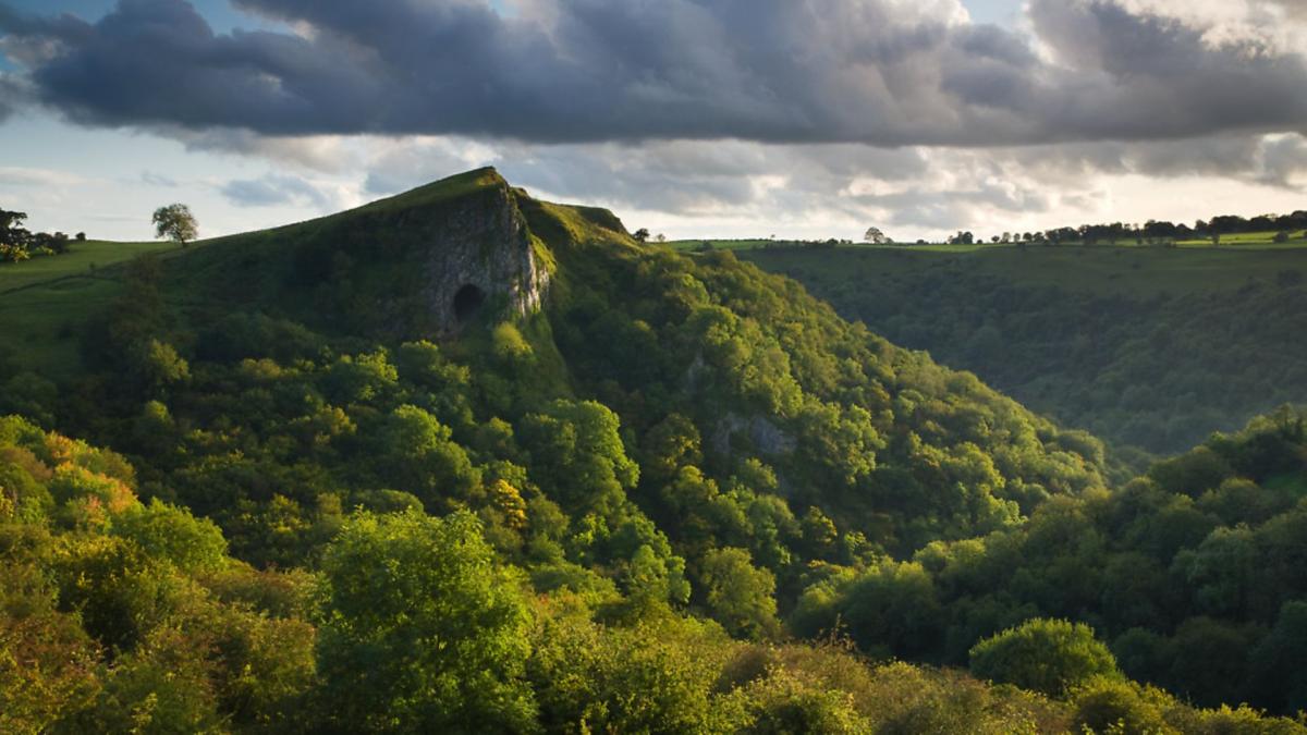
10. Towards the southern end of the Peak District and to the west of Dovedale, lies the Manifold Valley – a wonderfully verdant and winding valley that is dominated by Thor’s Cave, which overlooks it. The cave itself, though a bit of scramble to enter, is worthy of exploration and offers fine views along the valley. It has an interesting history and is thought to have been occupied by ancient man from as far back as 10,000 years ago.

11. And finally, we conclude this leg of the journey in the Upper Dove Valley with a view of Chrome Hill as it is illuminated by the morning sun. Affectionately known as ‘Dragon’s Back’, Chrome Hill is formed from hardy reef limestone and is actually one of the few true ‘peaks’ in the Peak District. We will have the chance to see another one of these ‘true peaks’ in the next article.
In the next and final instalment, we will conclude our tour with a return to Dark Peak terrain, exploring the gritstone outcrops, moorlands and valleys of the South-Western Peak. Until next time…
Graham is a full-time photographer specialising in fine-art landscapes, interiors and portraits. He also enjoys sharing his passion with others, especially those who wish to take their photography to the next level, and offers workshops on a 1-2-1 or small group basis. For more information and to see more of his work please visit his website at: www.grahamdunn.co.uk


Comments: Our rules
We want our comments to be a lively and valuable part of our community - a place where readers can debate and engage with the most important local issues. The ability to comment on our stories is a privilege, not a right, however, and that privilege may be withdrawn if it is abused or misused.
Please report any comments that break our rules.
Read the rules here