
Peter James of Norfolk Ramblers takes us on a lovely walk for a summer’s day

Directions
1) Leave the car park by the bridge across the head of the staithe and turn left along the Wherryman's Way. Continue past Rockland Broad, where you may wish to pause to take advantage of the bird hide, then follow the path beside the broad to Short Dyke. Turn right, following Short Dyke to the bank of the River Yare; follow this, passing the pumping station.
Just before the gate to the Beauchamp Arms leave the Wherryman's Way and turn right on a path leading away from the river. Beside a dyke at the gate pass through and follow the track to the road.
2) At the road turn right and cross to the pavement. Follow this past Folly Lane; at the end of the pavement you pass a thatched barn conversion - you take the restricted byway on the left and follow for 800 metres to the brow where you come to a track before the electric pylons; this is Slade Lane. Turn right and you have good views of the countryside in all directions.
Follow the track to the end, turn right then left onto a narrow path beside the gardens. This brings you into the churchyard. Go through the churchyard to the gate to a road.
3) Cross the road to another path, follow around the field edge and then pass through a gap in the hedge. Go diagonally across the field; at the track turn right, follow the track round to the road.
Passing Burton's Farm turn left and continue until, shortly after crossing a stream, the road swings to the right.
4) Turn left away from the bend on to a track leading towards a house; where the footpath then goes down to the left following around the boundary, continue along a field edge.
Follow the signs round to the right, then left through trees and then right again on a clear track leading to the road at Rockland St Mary. Turn right and back to the start.
Points of interest
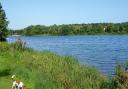
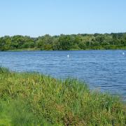
A) Rockland Broad and Marshes RSPB
Habitats at Rockland Marshes include reedbeds, wet grassland, wet woodland, pools, ponds and ditches. Work on the reedbeds includes removing scrub and invasive plants, summer mowing and grazing and seasonal flooding. The fen meadow is also managed for its flora and breeding snipe by maintaining water levels, clearing rushes, grazing and mowing, and trampling with livestock to create boggy ground. There are plans to restore more of this habitat.
The wet grassland is looked after for the benefit of wintering waterfowl and breeding waders, using grazing and topping to create suitable sward heights. Encroaching rushes and scrub are cut back and ditch water levels controlled.
Wet woodland is managed for key breeding birds, including warblers, willow tits and bullfinches. The pools, ponds and ditches are looked after for the benefit of aquatic flora, wildfowl, otters, water voles and bitterns. Work includes maintaining ditch edges, improving water quality, removing vegetation from open pools and increasing the number of fish.
Birds you may be fortunate enough to see around Rockland include mallard, tufted duck, common tern, greylag goose, Canada goose, heron, kingfisher and great crested grebe. The Broads were long thought to be a natural feature, but they are now known to be the result of medieval peat diggings.
B) Fine ancient church
St Andrew's is Norman and although much altered and added to over the centuries it retains the atmosphere of a simple country church - including the underside of the thatch visible in the roof.
At the end of your walk refreshments are available from the New Inn.
Get rambling
Norfolk Ramblers welcomes new members. If you are interested in walking in the company of like-minded people, visit norfolkra.org.uk or call 07505 426750. For queries about this walk, phone 07905 565740.
Norfolk Ramblers has established a footpath working group to do some path cutting and general maintenance. We try to make sure that all the paths in these walks are fit to walk, but if you encounter a problem please tell us.
Contact Peter James at pdjames.ramb@ntlworld.com; 07905 565740
Start/finish: Start Rockland Staithe car park
Distance: 5.5 miles, 9 kilometres
Parking: On the left before The New Inn
Refreshment: The New Inn
Map: Grid reference TG327 046
Post code: NR14 7HP
Ordnance Survey maps are available from all good booksellers and outdoor stores or visit our online shop www.ordnancesurvey.co.uk/al