
We welcome back Peter James of Norfolk Ramblers with this lovely set of walks around Alby

Directions
1) From the lay-by take the signed path beside the fence. Go over the stile, follow the cross-field path. At the far side turn right on the track. Follow this, ignoring the path off to the left; keep ahead along the right edge. At the next corner turn left on a track leading to Manor Farm, then from the farmyard turn right along another track to Hanworth Church. Bear left and follow the road. At the end of the hedge there are excellent views of Hanworth Hall. Carry on along the road. Passing over the cattle grid follow the road to the junction. Turning left and passing the ponds the Wherryman’s Way joins from the left; cross the cattle grid, follow the road uphill. Around the corner you will come to a path marked Wherryman’s Way; follow, passing Malthouse Farm to the road.
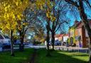
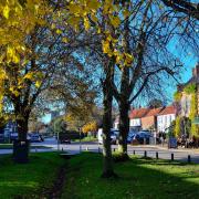
2) If doing the short walk turn left, follow the road passing the school on your left. Passing a junction off to the right after a few metres there is a track off to the left. After a short distance at the marker post turn right, then at a junction of paths turn right. This is Pack Lane – follow this to the road. Turn right, then left along the field edge; it then turns right then left. Passing through the old graveyard at the road turn left to the church where you re-join the main walk at (4). For the main walk turn right, passing Manor Farm you will come to a path off to the left. Follow this down to Aldborough, with its large village green. Turn left then right following the green and passing the children’s play area off to the left. At the road turn left, passing the commercial properties, turn left, follow the lane and at the end bear left through a gap. Follow the path through trees and over a footbridge, then continue along the field edge to the road. Turn left up Middle Hill; just before the T-junction turn sharp right you can shorten the walk here joining the short walk at the T-junction.
3) Just before the T-junction take the path to the right following the field edge to the road. Turn left then take the path this side of the church. At the church there is a path from the rear that joins the field edge path; follow this, going straight on. At the field boundary at the top of the hill the path bears left then follows a cross field path diagonally; to join the road go straight on with the common on your right for 400 metres. At the end of the woods, just before the house, there is a signed path up the steps beside the woods. At the end of the woods carry straight on, following the cross field path to the track. Carry straight on to just before the farm buildings; take the permissive path to the right through the trees. At the end turn left up the road to the church.
4) After visiting the church turn left, follow the road for 240 metres but take care – the road can be busy. You will come to a signed track on your left; follow this to where you joined the track on the outward leg, turn right along the cross field path over the stile returning to the layby.
Points of interest
Church of Saint Bartholomew
The church organ built around 1865 by ‘Father’ Henry Willis, the famous London organ builder, originally cost £70 - it is Norfolk’s only miniature Father Willis organ.
Hanworth Common
The common covers 35 acres, protected by cattle grids, and is the largest such enclosed common in England.
Ordnance Survey maps are available from all good booksellers and outdoor stores or visit our online shop ordnancesurvey.co.uk
Get rambling
Norfolk Ramblers welcomes new members. If you are interested in walking in the company of like-minded people, visit norfolkra.org.uk or call 07505 426750. For queries about this walk, phone 07905 565740.
Norfolk Ramblers has established a footpath working group to do some path cutting and general maintenance. We try to make sure that all the paths in these walks are fit to walk, but if you encounter a problem please tell us.
Contact Peter James at pdjames.ramb@ntlworld.com; 07905 565740
Compass points
Start: at the layby just after the junction for Aldborough
Grid Reference: TG210340
Post code: NR11 7AE
What3words location: /// informed.hexes.count
Note: What3Words is an app which can help you navigate to a more precise point than just the postcode. Download the app or visit what3words for more.
Main walk: 7 miles 11km
Medium walk: 5.5 miles 9km
Short walk: 4.5 miles 7km