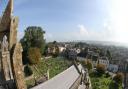
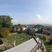
SIMONE STANBROOK-BYRNE finds a walk which has a fabulous start and ending in a pretty village this month as she takes a hike from Harberton Photography by James Clancy

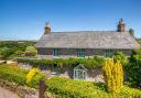
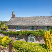
This delightful, friendly village, which derives its name from the River Harbourne, makes a perfect base from which to start a walk. And its wonderful 13th century inn, a former church house, is an excellent place to finish!
Church houses were the medieval equivalent of village halls, their main purpose having been to raise funds for the church. Often they would be venues for ‘church ales’, a celebration of sport, plays and Morris dancing – all enhanced by strong beer. With the rise of Puritanism such shenanigans were deemed inappropriate and church houses were closed.
After 1600 the buildings began to see use as schools, poor houses or inns as we see here in Harberton. Over 60 church houses are known to exist in Devon. Nearby you may be able to top-up on marmalade, fudge, cakes and greetings cards at one of the most appealing wayside stalls we’ve ever encountered; it’s set into a garden wall near the inn.
1 Starting outside the Church House Inn, walk away from the church down the lane. Cross a small junction and keep straight on past St. Andrew’s Cottages on your left. You reach the main lane through the village; turn right, passing the bus stop and phone box on your right. Keep ahead on the lane away from the centre of the village, passing lovely houses and a junction called Triangle. The Harbourne River eventually joins you, down on the right. The road crosses the river on a small stone bridge and you reach Leigh Bridge Cottage where a footpath goes left off the lane. This is just over half a mile from the centre of the village.

2 Here leave the lane and go left on the footpath, crossing a ‘patchy’ area and soon entering a field. Cross it towards the left-hand of the two gates ahead. (At the time of writing the arrows on these gates had disappeared. The council has been informed.) Enter the next field and cross this, heading very slightly right up to the top boundary, crossing a damp area at the bottom of the field before you start to climb. When you reach the top boundary you’ll find a gate on to a track. Pause here for a breather and to admire the view back towards Leigh Bridge Cottage and beyond.
Turn right along the track and follow it until it emerges on to a drive. Turn right, away from the house. The drive forks around two sides of a fenced private garden and reaches the lane that runs through the hamlet of East Leigh.
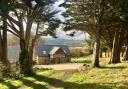
3 Go left on the lane, enjoying expansive views. In about 400m the lane swings left at the entrance to Foales Leigh; here a footpath fingerpost points you straight ahead along their drive – follow this. In another 400m the drive bends left (straight on goes into a farmyard which you don’t want). Go left with the drive, descending to cross a small ford and passing the attractive buildings of Foales Leigh. The obvious track continues beyond, keep with it, rising gently before starting to descend, at which point you have glorious views to look forward to.
600m from Foales Leigh, as the track continues ahead into a field, look out for the yellow arrow which directs you left off the track, to enter an adjoining field beneath a hollow tree. Head down the field with the boundary to your right, aiming for a gap in the opposite boundary. Here another arrow directs you to continue downhill and you’ll soon reach a footbridge crossing the delightfully-named Beenleigh Brook, a tributary of the Harbourne. There are some recent earthworks around here for new drainage.
4 Beyond the bridge continue through the next field, boundary to your right, and in just over 100m you’ll see a four-way fingerpost near another footbridge beneath the trees on the right. Turn left away from the post, still in the same field and now keeping the line of the top boundary to your right. At the end of the field you find a stile in the corner. Cross here and continue through the next field. The right-hand boundary soon ends, keep ahead, aiming for a bungalow across the field. To the right of this you’ll find a gate leading on to the lane.
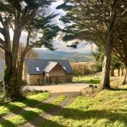
Turn left along the lane, ignoring a right turn in 100m and looking out for grazing alpacas who will give you a disdainful stare as you pass. Cross the river again at Rolster Bridge, beyond which you reach a junction. Turn left and follow this lane for 400m to arrive at Monks Oak Farmhouse. Here the lane swings left but you keep ahead on the ascending green lane, probably the steepest part of the walk, but gradually the ascent lessens.
5 As you climb you’ll pass gateways on your left, an opportunity to pause and enjoy views across East Leigh to the distant hills of Dartmoor. It can be tacky underfoot on this track. Keep winding up with it and eventually you’ll be rewarded with a downhill stretch. After a left bend Harberton will come picturesquely into view ahead and soon you’ll reach the farm of Key’s Englebourne. Go left at the end of their lovely rounded wall, heading along another green lane. Beautifully dappled in sunny weather, this is another lovely ‘old way’ that feels like it’s seen centuries of travellers. Again, it can be wet underboot.
The track continues for over 750m, eventually passing (avert your eyes) a tiny sewage plant down to the right then ascending to reach a T-junction of tracks. Go right here, heading downhill to arrive in the village at the bus stop. Bear right across the lane to the junction then turn left to retrace your steps back up to the inn and the church.
If time permits, round off your walk with a visit to the church. The striking marble mausoleum in the churchyard was raised by the parents of Robert ‘Tito’ Harvey, who lived at nearby Dundridge. Having gone away to boarding school in 1895 with a cold, his condition worsened and he tragically died less than three weeks later, aged ten. He lies here beside his parents. His younger brother, Emile, and older sister, Lilita, are buried elsewhere.
Directions to start:
Harberton is three miles south west of Totnes, accessed via lanes from the A385
Start point: Outside the Church House Inn. Grid ref: SX777586. Postcode: TQ9 7SF
Parking: On road in Harberton, with courtesy towards residents
Public transport: Harberton is served by bus operators Tally Ho! and Harbourne Shuttle. Timetables from travelinesw.com
Map: OS Explorer OL20, South Devon, Brixham to Newton Ferrers 1:25 000
Terrain: Field paths, tracks and quiet lanes. Some areas wet underfoot
Distance: 4¼ miles/6.8km
Dog friendliness: Good – but Pandora wasn’t allowed in the churchyard
Exertion: Some longish ascents but not too dreadful
Refreshments & Comfort stops: Church House Inn, Harberton, 01803 863707
Look out for...
Wayside shop near the Inn
Historic church with mausoleum
Expansive views to Dartmoor