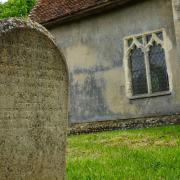

David Falk, Suffolk County Council’s Green Access manager, strides between Sizewell and Snape as he starts scoping this year’s Suffolk Walking Festival Challenge Walk

“Here you are.” “What’s that?” “It’s a map of our walk today.” “But I can’t read maps.” “What?!?!”
It’s the first day scoping this year’s Challenge Walk (May 19 – 22) and I’m joined by Hilary, a friend who’s been on the last four walks.
This year she’s embarked on a 1000 Mile Challenge and is keen to grab every opportunity to clock up more miles. Plus, I need someone to help me out, so that there’s a car at each end of the walk, to bounce ideas about the exact route, and to help out map reading. Oh well, two out of three isn’t bad.
Since 2012 the Challenge Walk has been the blue ribband event of the Suffolk Walking Festival. It began with a conversation in 2011 following comments that the festival lacked long distance walks. A few weeks later I’d developed plans for a 70-mile walk between Flatford and Mildenhall, following the St Edmund Way, a long-distance route created by The Ramblers.
It sold out. Indeed, it sold out before any other walk that year. Forty people turned up on the first day. Five completed the challenge and were rewarded with medals, t-shirts and a cream tea. The festival had caught a mood, tapping into a growing interest in the outdoors and challenges. The following year’s challenge was the Suffolk Coast Path – 70 miles in five days, 16 people completed it. Then the Angles Way, a beautiful long-distance path along the Suffolk/Norfolk border, 90 miles in six days, completed by 23 people.

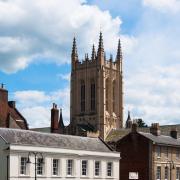
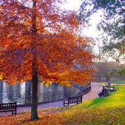
This year’s challenge, sponsored by Suffolk Secrets, follows The Sandlings Walk, a long-distance trail that winds its way through the Coast and Heaths Area of Outstanding Natural Beauty. Starting in Southwold and ending in Ipswich, the walk links areas of forest, heath and marshland, a landscape that once smothered most of Suffolk’s coastal strip.
There’s little of the Sandlings landscape left today, small patches of forest-green and sand-yellow stand out on OS maps, but in the 1930s this was a vast area. Eighty percent has been lost since then and the Sandlings now makes up just 1% of the world’s remaining lowland heath. It’s a very special landscape, worth exploring and worth celebrating.
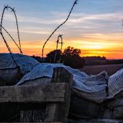
“You really can’t read maps?” “No, I’m actually well known for getting lost.” Tales follow, of walking holidays going west instead of east, losing the route, being out for hours. “What if I map read, and you keep a track of times and distances?” “Agreed!” We stride away from Sizewell Beach heading inland past the Vulcan Arms.
The pub sign makes me smile – it depicts a Vulcan Bomber, the God of Fire and Spock. Sandy tracks lead ahead and our pace is fast. We’re soon passing fields of pebble chomping pigs, past gates into Aldringham Walks, and onto the former railway line that once ran into Aldeburgh. Here we reach one of my favourite spots in Suffolk. It’s a bench.
Sitting quietly on its own, by a small cottage, the bench is just off the main path. It overlooks North Warren Fen, an expanse of reeds, home to bitterns, marsh harriers and bearded tits. In summer, hobbies dart about catching and eating insects on the wing. Egrets frequently sound off as they jump between pools. I could while away hours on this bench.
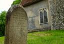
Hours we don’t have. From my bench we explore different options around the fen, deciding on the best route for the Challenge Walk. And then we’re off, crossing the countryside towards Friston Church which also has a bench, tucked up against the south porch. This one proves a perfect lunch stop. A friendly dog sniffs out the smell of warm soup, cheese wraps and tepid tea. “Come back,” barks its owner. “She’s OK,” says her partner. I think I should be the judge of that. I don’t mind dogs, but not in my soup.
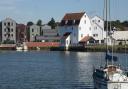
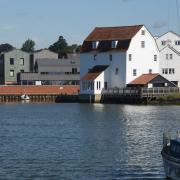
From Friston, the Sandlings Walk drops down towards the River Alde and destinations end at Snape Maltings. The Maltings is the perfect end to any day in Suffolk. The setting, among tidal mudflats, expanses of reedbeds reaching as far as the eye can see, and the solid Maltings itself, is iconic.
We seek out the café and talk about the day’s walk. We share stories of our love of walking, and get into a deep discussion on how the physical act of walking forward, eyes front, is incredibly powerful. “It engages a different part of the brain,” Hilary explains. “Maybe this is why Nietzsche famously stated ‘All truly great thoughts are conceived by walking’,” I reply. A walk really does help you think better, sorting out any problems in your world.
We then discuss the route in detail and work out distances between key points. We identify suitable resting points, places where a guest speaker could talk about the landscape, wildlife or history, and seek out any shortcuts should there be delays on the day.
As we chat I scribble notes all over my map. I work out walking times for the day, calculate where we should be at what time to keep to schedule. I offer the finished map to Hilary. “Any other ideas or suggestions?” She laughs, pushing it away. “You know I can’t read maps!”
__________________