
Take a tranquil walk in the Vale of Taunton Deane where Simone Stanbrook-Byrne discovers a historic deterrent to unruly behaviour

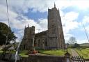
Tucked away in the west of the county, just outside the Exmoor National Park, Skilgate is a tiny village centred on the bijou and historic church of St John the Baptist.
It is an area of small, swift streams and undulating countryside, where vast views reward those who climb the hillsides surrounding the village. The route hops over the border into Devon, but you won't notice the join.
Pockets of mixed woodland provide a good spot for wildlife watching and have the potential for lovely autumn colour. Come back in spring when the hedgebanks are jewelled with wild flowers and bluebells colour the woodland floor.
Pick a sunny day, pack sandwiches and a flask and enjoy this tranquil walk away from the bustle.
1. Skilgate is tiny, its church is a little gem. Start the walk with a visit, noting the old village stocks in the porch. No one knows how old these are but stocks were a historic deterrent to unruly behaviour. They hang here as a reminder of times long before ASBOs were thought of. Miscreants could be detained in stocks for days at a time, fed on bread and water. The list of 'criminals' who could be punished by a spell in the stocks is interesting: drunks, vagabonds, rogues - and even those caught swearing. So watch your step and your language....
Leave the church and turn left along the lane. About 50m beyond the church turn right down St John's Close. In just over 100m go right at the T-junction, then, in 60m, turn left along the drive of Hendover Farm. In another 50m go right on the signed public byway, uphill along a rough track.

2. The early ascent is steady with frequent gateway views to offer a breather. Glance behind occasionally, the views are good there too. The track goes downhill to cross a stream and continues, ducking beneath trees for a while. Keep going until it enters a field. Continue in the same direction, following the left hedge. Part-way through the field a gate on the left gives a view to Haynes Down Farm - don't go through it. Continue to the end of the field where you find an arrowed gate and a big view ahead.
Continue beside the left hedge. We found a once-scarecrow along here; we did our best to resurrect him but he was too far gone. In the field corner pass through the gate and continue to a bridleway gate 50m ahead.
3. Beyond this there are gates to left and right; ignore them and keep ahead along a slightly sunken track.
The track descends to join a lower track coming in from the right, near which is a small pond with an old army vehicle draped in camouflage netting. Keep straight ahead as the tracks converge, ignoring tracks going left and right and following the broad earthy bridleway downhill between trees. The way passes pheasant fencing on the left and associated sheds. Streams run overground here, joining one another and sharing the track with you in an aqueous, tree-flanked area, good for wildlife. Dog's mercury grows in the verges, a plant that is considered to be an indicator species for ancient woodland. Keep your eyes open for deer tracks. Beyond the wet area the bridleway passes through a gateway - keep going.

4. The track drops down to reach buildings with a couple of loose boxes on the right. Horses leaned out to have their noses rubbed as we passed. A few metres beyond here, before you reach the surfaced yard, a fingerpost indicates that the bridleway goes sharp right, dropping down on an earthy path to cross a stream. Follow it, soon arriving at a surfaced drive and fingerpost by South Combe Farm. Go left, the farm buildings to the right of the bridleway. You soon reach another fingerpost, go right, passing gardens in front of the farmhouse. Follow the track until it reaches the lane then keep ahead along it. In 150m you reach another lane at a bend; go right - you are now walking in Devon. Follow the lane for just over ½ mile, passing, at roughly the halfway point, an area of rather shambolic debris - turn a blind eye! Just after this ignore a footpath on the left near an ochre-coloured house and keep going along the lane. It bends right and left as it approaches Morebath Cricket Club.
5. Near the cricket club, at Claypit Cross, turn right, approaching the wrought iron gates of Morebath Manor. In about 50m the lane bends left near these gates and here a fingerpost indicates a footpath going right along a rising stony track, take this. In another 40m a yellow arrow directs right along the track to West Wing Court. Follow this and keep going along the track until you reach the court; yellow arrows help whenever there is a fork. Continue beyond West Wing Court on the ascending track - the chimneys of Morebath Manor can be seen to the left. The track goes beneath trees and rises to a fingerpost. Go right, the views opening up to the right as you continue to climb. Wild strawberries grow in the bank beside the path, a distraction from the puff, if passing at a fruitful time of year.
The gradient reduces as you reach a fork. Keep right, along the lower path, although it soon goes uphill again, climbing, ever climbing and twitching left then right. You have no choice but to stay with it.
The track levels out and goes through a gateway by two oaks, continuing in the same direction. Very soon it mercifully starts to descend, an ancient tree-topped boundary to the right of the track and expanding views to the left.
 Crown copyright 2019 Ordnance Survey. Media 003/19")
The bridleway drops to a newish farm gate (the arrows hadn't been reinstalled when we passed) and enters a field. Keep going beside the right-hand boundary, climbing at first. Pause to glance behind back into Devon; in the far distance you can see the mast at Stoodleigh Beacon and a stand of nine wind turbines near Rackenford.
6. At the end of the field veer left, away from the gate in the top corner to a lower, yellow-arrowed gate leading into Skilgate Wood. There now follows a delightful stretch of walking, following a clear path down through the trees, initially at the edge of the wood - the field often visible to the right. This is lovely mixed woodland, good for nimbling squirrels and birds; buzzards mew overhead and we found a nuthatch investigating a fissured tree trunk. Moss-covered chunks of gnarly wood flank the path.
The path drops and, 400m from the start of the wood, joins a blue-arrowed bridleway. Swerve left here to join this broader track and continue to descend, reaching a gate out of the wood in 200m.
Keep ahead on the track beyond and follow it, crossing a stream and passing an occasional house. It emerges at a meeting of ways and arrives at the lane. Go straight ahead along the lane and you're swiftly back at St John's Church in Skilgate. The stocks await.
Good to know
Map: OS Explorer 114 Exeter & the Exe Valley 1:25 000
Directions to start / parking: Skilgate is off the beaten track eight miles west of Wiveliscombe, very close to the Devon border and accessed along country lanes. There is limited parking near the church and on the lanes around the village but please be considerate towards residents. The Village Hall committee has kindly said that walkers can use their car park if there is space - perhaps pop a donation in the church box if you do. Grid ref: SS987272. Nearby postcode: TA4 2DQ
Distance: 4¼ miles/6.8km
Exertion: Moderate to strenuous - there are some long ascents
Terrain: Tracks; field and woodland paths; stretch along very quiet road. Some sections can be quite wet underfoot so stout boots essential
Dog friendly: Yes, but animals grazing the fields
Facilities and refreshments: None en route but a handy bench outside the church makes a pleasant picnic spot. The Village Hall committee has also kindly said that if the hall is open walkers can use their toilets - again I suggest you pop a donation in the church box if you do. The nearest places for refreshment are Dulverton or Bampton, both just over five miles away.