Across Devon, many villages and towns have Walk & Talk schemes. Devon Life walks writer Simone Stanbrook-Byrne joined one near Silverton, just before lockdown kicked in.

Walk & Talk, England’s largest network of ‘walking for health’ schemes, has been thriving in Devon – one group in the county has been going for nearly 20 years. Across the country there are more than 600 such schemes , and they are regarded as one of the keys to beating the national epidemic of inactivity, helping people to lead a healthier lifestyle with the added bonus of social interaction.
Although restrictions on such gatherings were in place at the time of writing, in due course these will be lifted. One morning, just before the lockdown, I joined in with the Walk & Talk group in my nearest village and discovered just how much fun is to be had during a very sociable morning.
The route follows some recently re-routed footpaths and, being quite short, would make a good family amble for the summer holidays.
Route:

1. When I arrived a good crowd was already assembled outside Silverton’s Community Hall on Wyndham Road, and discussion was underway to determine which of the trained leaders would lead which route.
Today was Wednesday, which meant the group would divide, some going on a slightly longer walk than others (the Tuesday group had already had a much longer outing the previous day).
Buster, a very jolly Jack Russell, wanted to walk further than his mum. He picked a human to hold his lead and a dozen of us set off on the longer walk, guided by Pete, who in turn was ably supported by adorable 15-year-old Benji, the kind of curly-haired dog everyone wants to take home.
We whizzed along Wyndham Road to reach Coach Road at the far end, opposite the primary school. A member of the Local History Society was with us and told us that Coach Road once led to the erstwhile rectory, Prispen House, but this splendid building burnt down about 30 years ago, to be replaced by a new residential development with the same name. The road was once graced by majestic elms, an occasional stump being all that remains of them.

2 To the right of the school a footpath took us gently uphill, bending round to reach a gate into a paddock where ducks and chickens wandered. On the opposite side of the paddock another gate brought us into a larger field.
The footpath here goes across the field for about 100m before sloping steeply down to the bottom hedge, aiming to the right of pale blue Livingshayes House. A solid wooden kissing gate at the bottom took us out to the lane. We turned left along the lane for a few metres before joining a footpath on the right, hopping over Heal Eye Stream, an historic watercourse reputed to have healing powers.
3 This path provided a short, sharp incline that got our collective hearts pumping. Through the gate at the top we paused, just to let the dogs get their breath back.
From here we continued generally uphill, though more gently now, following the left-hand edge of the field. We reached a fingerpost and paused, allowing everyone to catch up and have a natter. I learned that Pete started leading these walks after retiring from the Met Office in Exeter. He’s a dab hand with weather apps on his phone.
From the fingerpost the footpath has recently been re-routed. It used to go right, across this large field, but not anymore. Instead we kept ahead along a track out of the field and downhill. In about 100m a narrower path goes left at another fingerpost, but we kept straight on along the main track, soon bending right and beginning to climb again (this section is not yet shown as a right of way on the OS map).
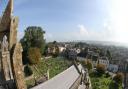
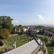
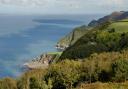
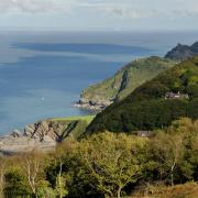
The track continued uphill, the field stretching away to the right, before levelling out and arriving at a fabulous viewpoint where we worked out what we were looking at: the Sidmouth Gap, the sea beyond Dawlish Warren, Haldon, Dartmoor, the lone pine on Raddon Hills...it really was spectacular and well worth the climb.
How about trying this circular walk on Dartmoor ?
4 From here we turned right, staying in the same field and following the left-hand hedge (an arrowed post directs). In 150m we rejoined the old footpath, turning left at a yellow-arrowed footpath gate and following the hedge downhill for 350m, enjoying views across the village to the right.
At the bottom a gate took us into the next field and here there is another diversion from the map: to avoid road walking the landowner has permitted a path round the perimeter of the field, so we all turned right, keeping the hedge to our right for 200m. In the corner, we swung left with the hedge, following it down to a newly installed footpath gate onto the road.
5 Once we were all through the gate we turned sharp right, away from the road and along a footpath beside a garden fence; Heal Eye Stream is back with us briefly here. The path widens out, becomes Park Close and in 150m reaches Coach Road.
Here we turned right, walking along the road to reach the primary school again. (Those without dogs can divert left along here to visit ‘The Rec’, with its benches, playground and superb ancient oak tree, the symbol of Silverton.)
Ignoring Wyndham Road on the left, which would take us back to our start point, we continued about 40m further towards the entrance to Prispen, then turned left on a narrow path opposite Prispen Drive. This took us past back gardens and brought us to Parsonage Lane in 100m, so named as it used to go to the rectory.
6 Another left turn along Parsonage Lane and we were soon passing some very old cottages and a former police house. We then all started walking faster as The Lamb Inn had come into view. Although it doesn’t really open until noon the jolly good news was that, prior to Covid-19 worries, for Walkers & Talkers, it was opening early for coffee and biscuits. An excellent and convivial way to round off a delightfully sociable walk.
To return to the car park, turn left out of Parsonage Lane, in front of The Lamb, and wander along Fore Street with its many historic houses. In 150m a path on the left, signed for ‘Health Centre’, leads back to the village car park.
Ordnance Survey maps are available from all good booksellers and outdoor stores or visit their online shop .
Compass Points
Start point: Wyndham Road, Silverton. Postcode EX5 4HL. Grid ref SS957030
Parking: On-road, with consideration towards residents. There is also a public car park on Wyndham Road
Directions to start: Silverton is signed off the A396, Exeter to Tiverton road, nine miles north of Exeter
Public transport: The village is well-served with buses from Exeter and Tiverton (see travelinesw.com)
Map: OS Explorers 114 Exeter and the Exe Valley 1:25 000
Terrain: Field paths and tracks; short stretch on residential roads
Distance: 2 miles (3.2km)
Dog friendliness: Good, though animals may be grazing
Exertion: Easy-moderate, there are a couple of uphill sections
Refreshments: The Lamb Inn , ForeStreet, Silverton, EX5 4HZ (01392 860272); The Silverton Inn , Fore Street, EX5 4HP (01392 860196)
Simone Stanbrook-Byrne has written a selection of West Country guides including: Favourite Walks in Devon, Circular Walks in the South Hams, Circular Walks in East Devon, Circular Walks in Central Devon, Circular Walks in North Devon/Exmoor, A Dozen Dramatic Walks in Devon, Town Walks in Devon.
Have you joined the Devon Life Facebook page yet?