
The South West Coast Path Association picks their favourite wheelchair and pushchair-friendly coastal routes in Cornwall

At the South West Coast Path Association, we believe everyone should have access to our coastline. That’s why we offer free information on where to go if you have more trouble getting around than your average walker.
So, whether you have difficulty walking, are restricted to a wheelchair or mobility scooter or just want to find a walk that’s suitable for a pushchair – we can help! Through our Walk Finder tool at southwestcoastpath.org.uk you can select easy access walks, which all have a worthwhile length along fairly flat paths that are at least 850mm (2’6”) wide, have a minimal cross camber, and no steps or stiles.
To judge whether a particular walk is suitable, each easy-going walk has a ‘Terrain’ description with a link to more information about the accessibility of the route. Clicking on this will bring up a fresh page with a more detailed map and photos showing the path gradients, surfaces and any gates.
In recent years, we have also carried out work to support the Countryside Mobility project, aimed at improving access to the countryside for people with limited mobility living in and visiting the South West. Thanks to this project, you can now easily find locations to rent a rugged mobility scooter or ‘Tramper’ as they are known, that will go smoothly across uneven paths. There are currently more than 30 sites where these mobility scooters are available.
Visit countrysidemobility.org/locations to find one near you.

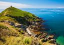
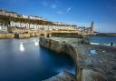
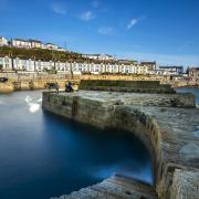
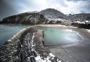
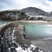
Glebe Cliff Tintagel
0.2 miles (0.4 km)
Start: Glebe Cliff Car Park
This is a very short and easy walk that gives the whole family the chance to enjoy the best of wild and romantic Cornwall. In autumn look out for the unusual cliff-nesting house martins gathering for their journey south, and maybe a merlin or a peregrine looking for prey.
The Route
The path takes you through a mix of coastal scrub and grassland. Plants and shrubs include gorse, bell heather, sea pink, kidney vetch, foxglove, toadflax, spring squill and sea campion. Look out for resident stonechats, kestrels and rock pipits, and, in summer, visiting breeding whitethroats.
This walk also affords cliff top views of the sea and of the island of Tintagel Castle, said to be linked to King Arthur.
The small car park at the start of the walk is close to the medieval cliff top church of St. Materianas. Its ancient graveyard hedge, built in the cursyway style, is encrusted with beautiful lichens. Near the car park there is an interpretation board, with information on the historical remains of local slate quarries, and a picnic bench. Both are wheelchair friendly. This walk can be accessed by tramper, wheelchairs and pushchairs. See the detailed description at phototrails.org.
Parking: Glebe Cliff (PL34 0DW) Tintagel Village (PL34 0AJ)

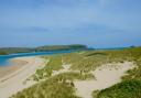
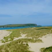
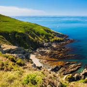
Stepper Point, Padstow
1.5 miles (2.4 km)
Start: Hawkers Cove
This is an easy walk, with a shorter version suitable in dry weather for some mobility scooters and prams, along grass and stone tracks out to the Day Mark tower and Coastwatch lookout station situated on a spectacular headland.
The Route
From the Hawker’s Cove Car Park (seasonal – when closed, limited parking on the road) near Lellizzick walk back onto the lane, turn right, and after about 100 metres take the path leading off through the gate on the left. From here follow the track around the edge of the field.
The farmland is managed under Natural England’s Higher Level Stewardship Scheme and has been allowed to naturally revert to the wild grass meadows. There are sheep and ground-nesting birds nest in the areas of rough grassland, so please keep your dog on a lead, particularly in the spring and early summer.
Late cutting for hay and silage protects ground nesting birds, as by the time the fields are cut the young have fledged. This is one of the best sites for skylark, particularly in early spring. Grazing has been introduced on the cliff slopes to prevent scrub encroachment. The grazing management here is helping to create a diversity of flowing plants for which the Cornish cliff slopes are famous.
When you reach a gateway, branch off left towards the cliff top (unfenced, so take care of children and dogs), close to Butter Hole you join the coast path. Following the coast path to the right the path leads along the cliffs to a Day Mark tower – erected to help mariners find the entrance to the Camel Estuary. This part of the coast path is a bit too steep and narrow for mobility scooters, but rugged scooters can get to the Day Mark by following the track leading towards the Coastwatch Institute and taking a left across the field once you are on the plateau.

The dramatic headland at Stepper Point marks the entrance to the Camel Estuary and features prominently in the opening episodes of Poldark.
Pass through the gap in the wall, just inland of the Day Mark and cross the field to reach the lookout hut manned by volunteers of the National Coastwatch Institute.
The waters around here have proved treacherous over the years, with the infamous Doom Bar – a ridge of sand close to the mouth of the estuary causing many shipwrecks over the years. From the lookout station a grass track leads back along the ridge and back to Butter Hole and the start of the walk.
Parking: Hawkers Cove Car Park (PL28 8HJ)
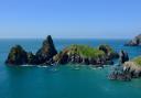
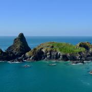
Godrevy Head
0.6 miles (0.9 km)
Start: Godrevy Head Car Park
This short walk has great views across St Ives Bay, and out to the lighthouse on Godrevy Island just off shore. Children will love the long beach, as well as the island and the lighthouse and the tales of shipwrecks. A good walk in spring, when the coastal grasslands are full of wildflowers and fulmars nest noisily in the cliffs, and in autumn, especially during strong winds, when huge flocks of migrating seabirds pass through, including kittiwakes and sometimes storm petrels.
The Route
From the car park follow the coast path out towards the headland keeping the sea on your left. A little way offshore is Godrevy Island with its lighthouse – the inspiration for To the Lighthouse by Virginia Woolf who spent many holidays in St Ives.
As you walk along, keep an eye out in the water for grey seals playing and hunting for fish in the surf, and for the pod of bottlenose dolphins that are often seen further off-shore in St Ives Bay. Guillemots, razorbills, fulmar and cormorant are among the many seabirds that nest on the cliffs around the headland.
Beyond Godrevy Island a dangerous reef known as the Stones extends out into St Ives Bay, and many vessels have been wrecked here over the years. It was the scene of a famous shipwreck in 1649. In the aftermath of the execution of King Charles I, followers attempted to send his lace trimmed garments and other possessions abroad for safe keeping as relics of the ‘Martyr King’. The ship was wrecked and only a few of the clothes were washed ashore.
Following the loss of the screw steamer Nile with all hands in 1859, public pressure led to Trinity House constructing the lighthouse designed by James Walker and was originally maintained by a two-man crew. The tower is 28-metres and could be seen for eight nautical miles. Originally driven by a clockwork motor, it now operates on solar power. In 2012 the light was moved from the lighthouse tower to a new steel structure on the adjacent rock.
As you come around to the north side of the headland, the path starts to descend slightly and as you pass Mutton Cove (there is no access down the cliff to the cove), a path leads off on the right, returning you to the car park. Alternatively the walk can be easily extended with a gentle stroll onwards along the coast path to the next headland, Navax Point and the Knavocks.
Here a small herd of Shetland ponies help maintain the mix of grassland merging into heathland and gorse scrub which provide an ideal habitat for nesting bird.
Parking: Godrevy Head Car Park (TR27 5ED) open from Easter to the end of October.
The car park at Gwithian Towans is open all year round.
Penzance to Marazion seafront walk
2.7 miles (4.3 km)
Start: Penzance Station
An easy walk from Penzance (or Marazion) that gives great views across Mounts Bay to St Michael’s Mount, the Lizard and Mousehole. It is especially good in autumn, when the Bird Reserve at Marazion attracts rare migrants such as bitterns and water rails, and the flocks of swallows hunting flying ants sometimes draw the attention of a passing hobby, an unusual bird of prey.
This walk is particularly good for dogs as it passes a beach and pubs where dogs are welcome.
The Route
Leading off from the car park is Albert Pier, built in 1845–7 to provide shelter from south easterly gales. During a visit to Cornwall in September 1846, Queen Victoria and Prince Albert landed at Penzance on the new pier, which was then still uncompleted.
From the car park the coast path heads east along a footway inland of the sea wall, (the path along the sea wall itself is a dead end) alongside the railway.
Penzance is the most westerly and southerly railway station in England and was opened by the West Cornwall Railway in 1852 as the terminus of its line from Redruth, but was subsequently incorporated into Brunel’s Great Western Railway linking through to Paddington.
After a few hundred metres the path rises up from behind the sea wall and the views open across Mounts Bay to the famous St Michael’s Mount (managed by the National Trust) linked to Marazion by a natural causeway passable at low tide. The path continues along this sea wall for the rest of the walk.
In Cornish St Michael’s Mount is Carrack Looz en Cooz, which translates as ‘the grey rock in the wood’ and this may represent a folk memory of a time before Mount’s Bay was flooded. Certainly, the Cornish name would be an accurate description of the Mount set in woodland. The Cornish legend of Lyonesse talks of land being inundated by the sea, and there is strong evidence of sea levels being much lower in the past, with the channels between the nearby Isles of Scilly only being inundated around 400–500 AD. Remains of trees have also been seen during low tides following storms on the beach at Perranuthnoe just a few miles further along the coast.
During summer the boulders forming the sea defences are full of wild flowers such as the pink mallow whose waxy leaves help conserve moisture in the harsh dry, salty conditions, that would kill most other plants. There are regular paths off the sea wall down on to the dog-friendly Long Rock Beach.
In the winter, thousands of starlings roost in the marsh, and at dusk you can the spectacle of huge flocks swooping across the sky as the gather for the night.
Marazion itself is an attractive small town that is well worth exploring. There’s an active artists’ community producing paintings and pottery for the numerous art galleries.
Parking: Penzance rail and bus station car park (TR18 2LT)