Ever felt there was something missing on your walk or bike ride around Hampshire? You may be right – this county is peppered with dozens of former paths, roads, canals, railways and even airstrips, all either removed or built over but how many have you already discovered asks Faith Eckersall
Lost path under the sea
Before they built Hayling Island’s original timber toll bridge in 1824, you could only get there safely by boat. Unless you were prepared to risk the Wadeway - a submerged, three-quarter mile route between Langstone and Hayling. The route was the subject of an investigation by Hampshire Field Club and Archaeological Society in 2014, which concluded that it dated back to the Medieval era and was mentioned on a 1759 map as a ‘Horse Road at low water’. Parts of it are still visible today if you look carefully at the lowest tide between Northney shore and the Royal Oak at Langstone. It’s possible to spot the wooden stumps that marked its way but the route has been impassable since it was cut in two by the construction of the Portsmouth and Chichester canal in the 1820s.

The ‘Boldrewood Tunnel’
Deep under the University of Southampton lies the Boldrewood Tunnel, a pedestrian thoroughfare built – allegedly – between the Students Union and the Boldrewood Campus. Legend has it that the university closed it in 2004 because of ‘concerns for safety’. And legend is all it is. It may have acquired an internet presence and even had its own society but the only debate to be had is whether it’s a student prank or an enduring urban myth - as there is no reliable record of the tunnel being built, closed or used by anyone.
In contrast, a tunnel which sounds mythological but does actually exist is the one in Winchester’s Chesil Street. Sited in what is now the old Chesil Street car-park, it was built for the Didcot, Newbury and Southampton Railway and when it opened in 1885, boasted 15 staff. Despite its use as a troop station in the run-up to D-Day, the railway line fell into disuse and sadly closed. The tunnel, however, still exists and it now secure and used as a store by the City Council.

Disappearing railways
If you’d looked at the rail map of Hampshire in the 1950s it would look very different to the one you see today, with lines and stations sprouting everywhere. Then along came Dr Richard Beeching, whose notorious report advised the closure of hundreds of miles of railtrack and stations to save money. The Beeching Axe, as it was known, put paid to the line between Bishop’s Waltham and Botley and the Meon Valley Line, which became a trailway. Other lost Hampshire train routes include the Bordon branch line, the former Salisbury and Dorset Junction Railway which had stations at Breamore in the New Forest as well as in Fordingbridge, the Lee-on-the-Solent railway and the Fawley line. This sad demise has left the county with a number of quirky places, however, such as the siding at Droxford where Winston Churchill stayed in a carriage before travelling on to Southwick for D-Day (you can still visit the historic siding as part of the Meon Valley Trail) and the curious Durley Halt. Opened in 1909, the railway from Bishop’s Waltham to Botley was little used from the start and Durley Halt was its only official stop. The track is now a footpath at the Bishop's Waltham end but the forlorn remains of Durley Halt, nearer to Curdridge village, can still be seen. Despite its insignificance, Durley Halt does have one claim to fame – it was once named as the British train station or stop that people were least likely to alight at!

The Portsmouth and Arundel Canal
As lost routes go, this is one of Hampshire’s most extraordinary. It started grandly enough, with an Act of Parliament passed in 1817 and work commenced on the exciting new water route which would eventually connect Portsmouth to London via an inland waterway, helping keep valuable cargo away from coastal raids by the French.
The route was to be able to take ships, barges and watercraft through to Arundel and beyond, but disaster struck early on when a leak appeared, causing sea-water to contaminate local drinking water. Irritated bargees noted that the proposed route had just the 52 locks, tolls became an issue and vessels were also dependent on the tides which affected the watery thoroughfare. Despite being used to transport no less a cargo than gold bullion for the Bank of England, no one stepped up to finance the canal’s repairs and the Portsea section was abandoned by 1830.
However, the canal has many ghostly remains if you know where to look; in the naming of Portsmouth’s Arundel Street (after a basin was constructed there), Locksway Road, the Grade II listed sea-lock and basin at Milton, and the Milton Locks nature reserve, run by the Hampshire and IOW Wildlife Trust.

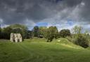
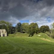
The road that became a meadow
It’s hard to believe, when you gaze upon it, that the peaceful meadows at Hockley just south of Winchester were once a furious blend of cars, lorries and other assorted vehicles, usually sitting nose-to-tail in what seemed like a never-ending traffic jam. It was that jam, and a desire to improve the inadequate 1930s-built road that led to the extension of the M3 motorway to create the Winchester by-pass. Which might not have caused so much infuriation itself, if it had proceeded through Twyford Down in a tunnel as most people wanted – rather than across it via a giant, ugly slice cut out of the historic and scientifically-important chalk downland. The protest - which began in 1992 - went on for three years, attracting international interest and support for the protestors, who endured harsh conditions. The protestors lost this fight but their efforts resulted in greater care being taken over subsequent road schemes. And now, all that’s left of the hated, outdated road is seven hectares of meadow.

Chocks away
Perhaps it can be seen as a monument to peace that so many of the war-time airfields that were sprinkled all over Hampshire just aren’t needed anymore. There are too many to list here but thanks to FONFA – the Friends of the New Forest Airfields charity – there is now a whole museum and heritage centre dedicated to the memory of those 12 in the county’s west. Based at the western end of the Heatherstone Grange Estate off Derritt Lane between Sopley and Bransgore, the FONFA centre opens on certain days (check their website fonfasite.wordpress.com) and displays histories of the airfields and the people who flew from them. Away from the centre, the New Forest Airfields Memorial at Holmsley South is worth a visit and the air services are further commemorated by memorials at Calshot and Hamble, remembering the airfields which were once based there.