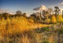
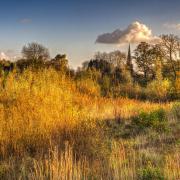
Winding sun-dappled lanes await the lyrcra-clad cyclist on this demanding but thrilling route along the eastern edge of the Peak District once, of course, the current lockdown is over.

‘Sumer is icumen in…’ rejoices one of the earliest written English poems, the mid-13th century ‘Cuckoo Song’. Time to oil that chain and go for a long edifying May ride!
May 1st is a red letter day in the folk calendar up and down the country with events such as the world famous Padstow Obby Oss Day seeing in the official start of summer. Derbyshire and the Peak District has its fair share, with the long-running Thaxted Morris Weekend at the end of the month, which has been running for 90 years! That’s a lot of hanky twitching and tankard clinking! May Day, perhaps better known today as International Workers’ Day (or ‘Labor Day’ in the USA), was originally known as the Celtic fire festival of Beltane – Gaelic for Summer. It was when cattle were driven between ‘bel-fires’ to banish the bad spirits of winter and bring in the luck and moved from winter to summer pastures. It was a time of great feasting and celebration, weddings and the pledging of troths. The fertility ceremonies which are still celebrated in obscure pockets of the land are a vestige of that. Whatever you believe, all that jigging about and hey-nonny no-ing can certainly blow away the winter blues!
First stop is Penistone – all change, as we venture over the border into Viking country! A market town traditionally located in the West Riding of Yorkshire, Penistone provides the perfect gateway into the Dark Peak. The place-name Penistone is first attested in Domesday Book of 1086, where it appears as Pengestone and Pangeston. Penistone is situated on a high ridge, which is believed to be the source of its name. Penistone derives from penn in Old Welsh, which means head, end, top, height or hill, and the Old English ing, a place-name forming suffix and tun, an enclosure, farmstead, village or estate.

The highest point, Hartcliffe Tower, is 1,194 ft (364 m) above sea level and has fine views over the Woodhead Pass and the Dark Peak. A rugged breed of sheep, the Whitefaced Woodland, can be spotted in the area. The folksinger Kate Rusby was born near here at Cawthorne, and her mellifluous tones make the perfect soundtrack for the drive up.
From here we will be plunging southwards along a hair-raising B-road – so make sure your brakes work! Try not to enjoy
the view too much on those hair-pin bends!
After many ups and downs you will be glad to see The Strines Inn hove into sight. This is the perfect place to stop and recharge. Originally a manor house built in 1275, over the years it was extended and eventually converted into an inn in 1771. The word ‘strine’ is an Old English term for the meeting of water, which is appropriate as the inn overlooks the nearby Strines Reservoir.

Coasting southwards, pause at the blood-thirstily named Cut-Throat Bridge car park if you want to visit the Hordron Edge stone circle (also known as the Seven Stones of Hordron). This Bronze Age stone circle offers impressive views towards Stanage Edge in the east, and Win Hill and Lose Hill in the Hope Valley, which seem to align with it in some mysterious way.
Pushing on from here, you will be heartened to know that the end is not far! Keep those wheels turning and soon you’ll be turning off onto the main A road to The Ladybower Inn – a short ride along, overlooking the eponymous reservoir. Here, you can hang up your clips and tuck into a well-deserved hot meal and a pint! And if you’re in luck, you may see some Morris Dancers jingling their bells and clacking their sticks to welcome in the summer! u
The Route

1. Starting in Penistone Railway Station, head west along the Sheffield Road (B6462).
2. Turn left at The Old Crown Inn, and continue up High Street (south).
3. As you climb the hill past the shops, the High Street eventually becomes Mortimer Road. You will be following this all the way to Ladybower, so as long as you stay on it you can’t go wrong.
4. You drop down to Midhopestones, crossing the A616.
5. Continue on Mortimer Road up the other side of the valley. This is a steep climb, but the views will make it all worthwhile! Fortitude!
6. Catch your breath as you coast along the edge of the Peak District, passing the turning for the wonderfully named Wigtwizzle.
7. Carry on – you’ve guessed it – the Mortimer Road south. When you pass Penistone Road on your left you’re in for an exciting descent down to Bradfield – be ready!
8. Some lovely riding down to The Strines Inn, where you can catch your breath.
9. From The Strines Inn push on past the reservoir to Ladybower.
10. Turn right onto the A57, then coast triumphantly towards the Ladybower Inn – crossing Cut-Throat Bridge, and passing the Hordron Edge Stone Circle (OS Map Ref SK21528685) up on your left – in case you feel like stopping to worship the sun!
Further reading
The Stations of the Sun: a history of the ritual year in Britain by Ronald Hutton (OUP, 1996)
Kevan Manwaring is an author and creative writing lecturer. His books include Turning the Wheel: seasonal Britain on two wheels; Lost Islands; and Pen Mine: itinerant thoughts of a Pennine Wayfarer. He is a keen walker and cyclist.
Before undertaking any journey, please check gov.uk for advice and updates on COVID-19