
We join the South West Coast Path team for a series of guided walks: up first Holywell St Piran

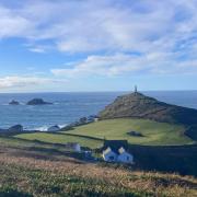
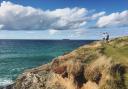
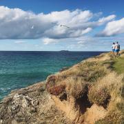
If you take one long bracing walk this winter make it an eight-mile hike along the South West Coast Path just south of Newquay, taking in the grassy sand dunes and seascape of the beautiful Holywell Bay.
It’s a challenging yet fascinating walk for the enthusiast, around Penhale Point and through the dunes at Penhale Sands. The fifth century missionary St Piran is said to have washed up here on his millstone after he was banished from Ireland, and the walk visits the remnants of his oratory, as well as various other holy sites attached to his name.
Boots on? Let’s go!
1. Leave the National Trust car park and turn right along the path next to the road. Follow the path as it bears left just before the St Piran Inn. This is now the South West Coast Path. Keep ahead on the sandy path, bearing left at the large slate waymark.

2. The Coast Path climbs gently to pass round Penhale Point, giving excellent views back over Holywell Bay. The lumps and bumps seaward of the path at the Point are the remains of the defensive works of an Iron Age cliff fort. Follow the Coast Path, waymarked by the acorn symbol, on to Hoblyn’s Cove, a deep and narrow cleft in the cliffs.
Here, as elsewhere around the entire area, traces of human habitation have been found dating as far back as the Mesolithic (Middle Stone Age) period, 6,000 years ago or more.
A striking feature of this part of coastline is the extent of the mine workings on and around the cliffs with records at Penhale mine dating back to 1777 and evidence that minerals were mined for centuries before. Ligger House, on Penhale Point, is the former count house for the mine. Auctions were conducted in the building, and miners would bid for underground leases (or pitches). Designated as a listed building, it is now owned and maintained by the MOD, who use it for non-operational purposes.
There is also an Iron Age cliff castle on Penhale Point, and a number of important Bronze Age barrows on Ligger Point.
3. From Hoblyn’s Cove keep on the Coast Path as it goes out around the headland of Ligger Point, giving a superb view over the extensive Perran Sands to Perranporth at the far end. Reaching the dunes behind the beach the Coast Path passes an information panel at a small old quarry site and arrives at a fork in the path.
4. Leave the Coast Path which forks to the right and follow the path to the left, a permissive path marked with green waymarks. Follow this across an access track and keep to the waymarked path ahead as it undulates across the dunes parallel to the beach. Be sure not to stray to the left into the military training area, marked by red and white posts.
5. After passing through a kissing-gate, continue ahead into a natural valley running across the dunes to the sea. Turn left here and follow the sandy path inland. When it forks, bear left to reach the MOD boundary and follow the path alongside the fence to arrive at St Piran’s Oratory.
St Piran, Cornwall’s national saint, is said to have built his first small chapel on a rocky outcrop on Perranporth Beach which still bears the name Chapel Rock. Although some of the building was still visible in the seventeenth century, little remains of it now, thanks to the sea’s erosion.
He built the oratory in its present position some time later, and began to preach from here. His sermons were very popular, and at 29ft by 12ft the chapel was too small to accommodate all his congregation. Over the years the chapel was enlarged and improved. Stone walls were added, and a rounded doorway decorated with three small heads. A priest’s door was put in by the altar, as well as a wide ledge. A tiny window was made to let in some light.
There were other structures around the oratory, and a sizeable graveyard, as well as a small lake nearby which prevented the building from being buried in sand. However, this drained away in time. The oratory duly disappeared in wind-blown sand, although it kept a place in local legend. Nineteenth century archaeologist William Mitchell carried out excavations and found three skeletons under the floor, including a very large one minus its head. According to the legends, St Piran was a very large man, and after his death, at the age of 200, his head was kept in a sacred box, bound with iron and locked, and carried around the county, along with various other holy relics.
By as early as the 10th century the sands had engulfed the oratory but it has been excavated many times since. It was surrounded by a concrete structure for protection in the early 20th century and after being buried for safety in 1980 re-excavated in 2014. An information board gives further details.
6. From the oratory continue in the same direction, heading towards a stone medieval cross just visible on the horizon (not to be confused with the large cross visible to the right). Walk to the cross, which is next to St Piran’s Church. There is another information board here.
7. From St Piran’s Church go to the medieval cross and take the path which heads towards some farm buildings on the skyline and marked by a small white stone (ie parallel to the face of the cross). Follow the most obvious path, marked by occasional white stones and, later, waymark posts, until it arrives at a surfaced road.
The early medieval cross in the dunes beside the ruined church was first mentioned in the tenth century, when it was referred to as the Cristel Mael’. Elsewhere around Perranporth are St Piran’s Well, to the north of Perranzabuloe, and Perran Round, at Rose. Here there is a medieval plein an gwarry’ or amphitheatre, unique to Cornwall, where miracle plays were staged. This is one of only two remaining in the county, and it is well worth a visit.
8. Turn left along the road and follow it past Higher Mount Farm and gently downhill through Mount, to where it takes a sharp turn to the right.
9. Turn left off the road and immediately bear right onto a footpath. Follow the path along the right edge of an open, grassy area then through trees and reeds to a footbridge over a stream.
10. Climb to a junction of paths and turn left. Follow the obvious path on a green lane, across fields then behind some houses (good views of the dunes of Penhale Sands) until it arrives at a surfaced track at Ellenglaze.
11. Bear left along the track and keep ahead as it becomes a footpath. This pleasant path then passes Holywell Bay Holiday Park before continuing on to arrive back at the car park and the St Peran Inn for a well-earned pint and a pasty.
Fact file
Distance: 8 miles
Exertion: Challenging
Start & Finish: The National Trust car park on Holywell Road TR8 5PW
More info: for more details of this walk and for a range other winter walks.