Wandering the waterside can add an extra restorative element to any walk. We pick 7 of the best in Devon
Devon is rich with opportunity for summer walks and adding sun-spangled water to the heady cocktail of fresh air and open space is always a plus. Many head for our glorious coastlines, but these areas can become a bit too populous for some, so in summer I often walk waterside paths away from the coast to enjoy a slightly more peaceful ambience.
These walk suggestions are précised, so if you are planning to leave the water and explore further afield, be sure to pack the correct map.
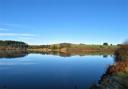
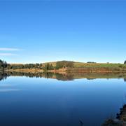
1. Meldon Reservoir
Map: OS Outdoor Leisure 28, Dartmoor 1:25 000
Start point: Meldon Reservoir Car Park. Grid ref: SX561917 (no postcode)
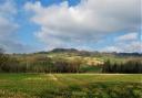
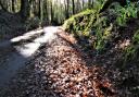
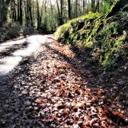
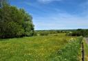
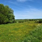
Dartmoor is one of our great breathing spaces, where wild open places are a magnet for the outdoorsy amongst us, but some of its notable beauty spots are man-made and have changed the landscape dramatically.
When it was built, Meldon Reservoir gave rise to much controversy and the nearby viaduct, a striking piece of ironwork, is also an arresting part of the landscape. Both can be regarded as beautiful in very different ways and they are now part of the moor and its heritage. Reflective views from the dam along the lake are glorious.
One of my favourite walks, although one that requires open-moorland navigation, follows the reservoir’s eastern bank, continuing along the West Okement River towards Black-a-Tor Copse, then climbing up to Black Tor. It’s a lovely downhill amble heading north from here across the moor, then west back to the reservoir.
This route is just under five miles. A longer and more challenging option (although one that takes you well away from the water) is to head up east from Black Tor to visit Dartmoor’s highest peaks of Yes Tor and High Willhays. After taking in the view from the highest point in southern England you can head back down to join the path that returns to the reservoir. This option is almost seven miles.
A small picnic area, not far from the dam on the eastern side, is a good spot to crack open the flask – and if you get no further than the banks of the lake you will still have had a lovely, mellow wander.
While you’re here visit the thatched Bearslake Inn with its spacious garden – they offer a warm welcome to walkers and cyclists.

2. The River Culm
Map: OS Explorer 128, Taunton & the Blackdown Hills 1:25,000
Start point: The bottom of Mill Street in Uffculme. Grid ref: ST071128; postcode EX15 3AT
The delightfully meandering River Culm between Uffculme and Culmstock is another favourite that’s good for the soul. I generally do this as a there-and-back walk of about five miles along the riverside path. It’s joyfully easy walking and can be superb for birding – last spring one of the ducks hatched 13 adorable ducklings – 26 legs all going frantic underwater.
The walk encounters snippets of history, following part of the dismantled Culm Valley Light Railway, and passes through Hunkin Wood, now a flourishing young woodland which was planted in the late 1990s as part of the Woodland Trust’s Millennium Project.
In Culmstock refreshments are available at Strand Stores and the Culm Valley Inn and there are also pub/café options in Uffculme, as well as The Orangery at nearby Bridwell Park, home of Lord Ivar Mountbatten (check websites for opening times).
While you’re here visit the still-working woollen mill museum at Coldharbour, a part of our industrial heritage that has been producing since the late 18th century. Check their website to see when the ‘steam-up’ days are planned.

3. Wistlandpound
Map: OS OL 9 Exmoor 1:25 000
Start point: Car park at south-west end of reservoir just off the road, plus an additional parking area down near the lake, signed from the higher car park. Grid ref: SS639415; nearby postcode: EX31 4SL
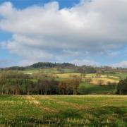
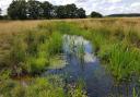
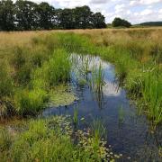
A charming name for a little-known reservoir in North Devon, this place offers good, accessible paths all the way round the perimeter. This is a short, easy walk of just under two miles – go round twice in opposite directions if you want a longer walk with different aspects. There’s a bird hide, so take the binoculars, and lots of places to sit and admire the waterscape – Wistlandpound is known for its turquoise waters.
While you’re here perhaps take in a visit to the National Trust’s Arlington Court with its interesting horse-drawn carriage museum. I once had a weekend of learning to drive with a difference here – a memorable occasion!

4. Watersmeet
Map: OS Outdoor Leisure 9, Exmoor 1:25 000
Start point: Lynmouth. Grid ref: SS723494; nearby postcode: EX35 6EX
For majestic scenery there is little to rival the deep wooded gorge and adjacent coastline around Lynmouth – though this can be a busy place in summer. From Lynmouth an enticing riverside path follows the East Lyn River for just under two miles through the gorge, to reach enchanting Watersmeet House, a place that has been serving teas since 1901.
You can stroll back along the river or, if there’s a need to work off any over-indulgence, a hilly five-mile route continues from Watersmeet up through the woods to Countisbury. From here it’s an airy and sometimes edgy walk high above the sea along the South West Coast Path, back down to Lynmouth.
While you’re here take a ride on the fabulous Lynton and Lynmouth Cliff Railway, the world’s highest and steepest, entirely water-powered cliff railway, which has been operating for 132 years.

5. Grand Western Canal
Maps: OS Explorer 128, Taunton & Blackdown Hills 1:25 000/OS Explorer 114, Exeter & the Exe Valley 1:25 000
Start point: The full 11+ miles of the towpath can be started at either Lowdwells, on the Devon/Somerset border (grid ref: ST074196; postcode: TA21 0JY) or at the Canal Basin, Tiverton (grid ref: SS963123; postcode: EX16 4HX). There are other access points to the towpath throughout, enabling shorter walks
Once upon a time there was a dream to create a navigable waterway joining the Bristol Channel with the English Channel, to avoid the hazardous sea journey around Land’s End. The Grand Western Canal was part of this scheme and the first section to open, in 1814, stretched between Tiverton and Lowdwells. But a changing world meant that the viability of the canal as a means of transport diminished and from 1925 it fell into disuse, gradually choking up.
Then, in 1971, Devon County Council took ownership and, since my childhood, I’ve seen this appealing waterway flourish as a long narrow country park, home to abundant wildlife and beloved by walkers and cyclists.
To walk the whole stretch from Tiverton to the Somerset border and back is a stout, if level, 22-ish miles, but there are lots of places to hop on and off the towpath for shorter walks. At the Tiverton end there are several canalside refreshment options and at Sampford Peverell The Globe Inn can be accessed from the towpath. Near Halberton there is a well-signed circular walk of 2.5 miles round the ‘Swan’s Neck’ section, which visits the café at Halberton Court Farm Shop.
While you’re here experience the canal from water level and take a ride on one of the last remaining horse-drawn barges in the country. The family-run Tiverton Canal Company, with its splendid heavy horses, operates from the Canal Basin.

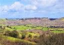
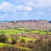
6. The River Teign
Map: OS Explorer OL28, Dartmoor 1:25 000
Start Point: Fingle Bridge Inn. Grid ref: SX743899; postcode: EX6 6PW
The Fingle Bridge Inn enjoys one of the most perfect summer locations that I know, with its terraced garden on the banks of the river. The Inn was formerly a tea shelter for anglers, founded in 1897 by Jesse Ashplant, and that delicious hospitality continues to this day.
Paths on both sides of the river offer a delightful three-and-a-bit mile amble, along one bank to the footbridge deep in the woods below Castle Drogo and back along the other side. The terrain can be rough in places. Along the river is an historic hydroelectric plant that has been restored and still supplies electricity to the castle high above.
While you’re here pop into Castle Drogo, in the care of the National Trust – this is England’s ‘youngest’ castle.

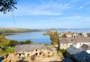
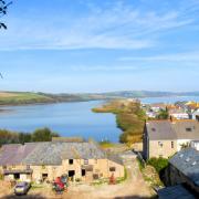
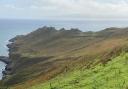
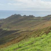
7. Noss Mayo
Map: OS Explorer OL20, South Devon, Brixham to Newton Ferrers 1:25 000
Start point: Noss Mayo. Grid ref: SX547474; postcode: PL8 1EG
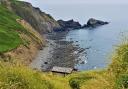
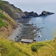
And for those who prefer the sea above all else, a superb, five-mile circular walk from Noss Mayo in the South Hams will fit the bill, with expansive coastal scenery and attractive creekside walking.
This route starts near the tennis courts in Noss Mayo, following the footpath past Brooking’s Down Wood to the coast. The South West Coast Path can be followed in either direction, but for the circular walk turn right, sea to your left, and just keep going, following the coast path and enjoying every step of the way.
The walk swings inland, heading towards Yealm Pool and Newton Creek. You eventually join the road back into Noss Mayo, where various refreshment options await.
While you’re here allow time to savour the village and what’s on offer. Sitting outside The Ship Inn is a fine place to relax after a great walk.