
The old Stour Valley railway line is no more, now colonised by walkers and wildlife. This circular route takes in sections of the trail and Sudbury's beautiful water meadows
By my reckoning, it was about 60 years ago that Dr Beeching was putting the finishing touches to his report on 'rationalising' the country's railways. The Reshaping of British Railways, written by Richard Beeching, was published by the British Railways Board in 1963.
The Beeching Axe, as it became known, would fall on 2,363 stations and 5,000 miles (8,000 km) of railway line - 55 per cent of stations, 30 percent of route miles, and thousands of British Rail jobs, in an attempt to stem huge losses in the face of increasing competition from road transport, and reduce rail subsidies.

Suffolk was hit hard, as the East Anglian Daily Times reported on March 28, 1963. Among lines with the axe hanging over them was the Stour Valley branch, serving Sudbury and Haverhill. The 43-mile Stour Valley line from Mark’s Tey to Shelford, near Cambridge – with a seven-mile spur to Saffron Walden and Audley End – would lose 15 passenger stations: Chappel and Wakes Colne, Bures, Sudbury, Long Melford, Glemsford, Cavendish, Clare, Stoke, Sturmer, Haverhill, Bartlow, Linton, Pampisford, Ashdon Halt and Saffron Walden.
Also hit was the Ipswich to Lowestoft and Great Yarmouth line. Along the 60-mile East Suffolk stretch from Ipswich to Yarmouth South, opened in 1859, stations that would close were Woodbridge, Wickham Market, Saxmundham, Darsham, Halesworth, Brampton, Beccles, Oulton Broad South, Lowestoft North, Corton, Hopton-on-Sea, Gorleston Links Halt, Gorleston-on-Sea and Yarmouth South Town. We still have the East Suffolk Line, fortunately.

As chairman of the British Transport Commission, Beeching had a job to do, of course, but viewed through the prism of history his actions are seen by many as short-sighted and damaging, especially for rural communities who had no other means of transport. Cars were still a relative luxury and replacement bus services were slower and less convenient than trains. Holiday and coastal resorts were badly affected.
The report also made no recommendations about what was to happen to the redundant land and infrastructure. A lot of it was sold off - such was the demand for land that hanging onto closed trackbeds for possible future use wasn't an option. But a few remain, in part if not entire, repurposed as attractive walking routes.
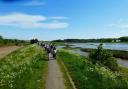
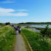
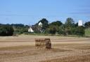
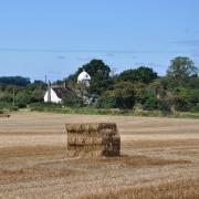
Railway walks are generally long, straight sections, for obvious reasons, but they're far from boring. They nestle in cuttings, spanned by sturdy bridges built to last by the Victorians, and traverse countryside and marshlands, their occasional iron bridges crossing rivers and quiet country lanes. Look left and right and there's the lovely view you would have enjoyed from your seat on the train, except there's more time to take it in. And their straightness makes them very easy to follow, which is useful if you find maps challenging.

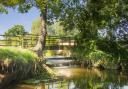
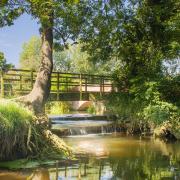
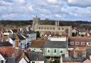
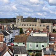
This circular walk takes in part of the three-mile linear stretch of the Stour Valley line between Sudbury town centre and Rodbridge Picnic Site near Long Melford. It mixes it up with Sudbury's wonderful water meadows, East Anglia’s oldest continuously grazed pastures.
The walk
1 The walk starts at Rodbridge picnic site, just off the B1064 at Long Melford. It's a little wildlife haven, created out of gravel pits that were used to build World War II airfields in this area. With my back to the entrance, I head to the right of the picnic area and go through a gate, over the road bridge crossing the Stour and almost immediately turn left onto the Stour Valley trail. After about a third of a mile, I come to a wooden trail marker where I turn right to leave the trail. At the road I turn left and head uphill for about 200 yards, past neat and tidy Borley Village Hall, reaching a bridleway on the left.


2 Keeping right of the hedge I follow the bridleway for about half a mile, with lovely views over the surrounding countryside, until it descends and bends sharp right along the field edge. I spy a couple of fallow deer, grazing peacefully.
3 Reaching a road - where a man is harvesting willow in the sunshine - I turn left over Bardfield Bridge and head uphill for about 0.75 miles until I reach Smeetham Hall Lane on the right. On the other side of the road is the public footpath that heads north east, towards Sudbury. The going is easy great views of the town in the distance. At the field corner the path bears right, then goes left through a hedge gap, continuing for about 1.75 miles, descending past some cottages (left) and over a bridge which spans the old railway track.


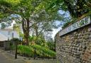
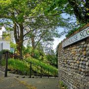
4 At the end of the bridge there are some steps (right) which go down the embankment. About 75 yards to the left, another steep set of steps takes me down to the disused Stour Valley branch line. In the railway days, the trees and hedgerows would have been cut back to allow the trains to pass through, but now they create a lovely sheltered path which is alive with woodland birds. I turn left and stroll for about 1.5 miles.


5 Just past the football ground I find a gate to a footpath on the left of the track leading into the watery world of Sudbury's Common Lands Nature Reserve. This ancient wetland, with ponds and ditches enjoyed by swans, and grassland which has never been ploughed, has been continuously grazed since the middle ages. In summer cattle still roam freely. It was an area painted by Gainsborough and Constable and has a timeless feel to it.


I head straight across the meadow to a footbridge over the river. Heading north, I follow the route across the reserve, passing the Mill Hotel, and up to the weir. I cross the bridge and follow the trail around a boating lake, then across the meadow again to a gate by another weir and a fallen tree. I then head over a little bridge and across the meadow. Through a gate, I follow the path as it winds between houses that make up the hamlet of Brundon. The path then merges into the Stour Valley Trail (6).
Heading north towards Long Melford, after about three-quarters of a mile, just past Borley Mill, I reach the point in the track where I left it at the start of the walk. I retrace my steps back to the picnic site, where there might just be time for a cuppa from Jenny Wren's excellent little outdoor cafe.
Compass points
Distance: Approx 6 miles/9.6 km
Time: 2.5hrs - 3 hrs
Start/finish: Rodbridge picnic site, Rodbridge Corner CO10 9HH (free parking)
Access: Public footpaths, roads, field edges, gates, steps, meadows (muddy in winter and wet weather). Note: Sudbury Common Lands Nature Reserve is grazed by cattle in summer and inhabited by swans and geese year-round. Dogs must be under control and the Countryside Code strictly followed.
Map: OS Explorer 196 Sudbury, Hadleigh & Dedham Vale
Ts & Ps: Rodbridge picnic site, Sudbury town, Long Melford