A lofty walk in the Blackdown hills where SIMONE STANBROOK-BYRNE discovers lovely autumn colours

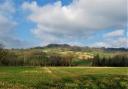
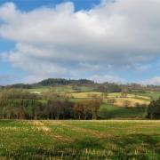
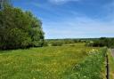
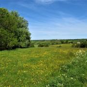
This lovely route on the edge of the Blackdowns has some of the most stunning views that inland Devon has to offer. It also takes in a monument to a communications system which predates emails and smart phones by centuries.
At the highest point of the walk is a beautifully-constructed stone hut. Inside this a pole was once housed, protruding through the roof to support a beacon fire, one of a series of beacons used to alert the able-bodied men of England to the imminence of attack from the Spanish Armada.
The hut's windows face in the direction of the two nearest beacons in the chain so that the beacon-keeper could watch for a neighbour's signal. There is some debate about the age of the existing hut.

It may well date from the late 16th century with later restoration but it is likely that there has been a beacon on the site since medieval times. Devon had more beacons than any other county in England, probably due to its extensive coastline.
Ponder the past; enjoy the present.

Route:
1) One of the best ways to start this walk is with breakfast in Culmstock's Strand Stores. After this, walk away from the War Memorial, the River Culm over to your right. Cross the ancient stone bridge and past the Culm Valley Inn. At the school the road forks; Wellington and Tiverton are signposted to the left but you keep ahead here, walking up Hunters Hill.
The houses gradually drop away and the lane bends left just over ¼ mile from the school. (A signpost here has recently lost its fingers.) Go right here; this lane bends right and within 200m you find a footpath going left off the lane along a farm track. Just over 200m along the track a stile on the right leads into a field.

2) Walk diagonally across the field towards farm buildings, heading towards another stile. Once over this follow the yellow arrows up a concrete track.
At the end of the concrete pass through the right-hand opening then continue in the same direction, following the left-hand field boundary. In the top corner pass through a gate onto a track.
Follow this track until you meet a three-way fingerpost. Turn left, soon passing a house on the left. The track becomes surfaced and reaches a T-junction where there are more houses ahead of you; turn right uphill on a broad track. After about 100m pass through a gate and continue uphill.

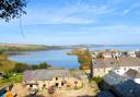
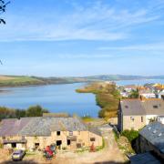
About 200m from the gate (and 40m beyond a narrower right-hand path) a wide track goes off right. Take this and follow it as it wends its increasingly panoramic way to Culmstock Beacon, an amazing place of thirst-quenching views and history. Near the hut there is a trig point and a beautifully-constructed bench, created by the children of Culmstock Primary School.
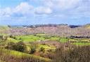
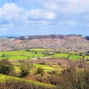
3) Just east of the beacon is a wide, grassy area from which three distinct paths head off in different directions. With the beacon hut behind you and the paths ahead, you need the most right-hand path, heading roughly east with the edge of the escarpment to your right. Jaw-dropping views open up over the Culm Valley.
Keep on this path as it passes gorse bushes and enters trees, then bends left. Continue with the sometimes-overgrown fence boundary on your right. When trees permit there are field and valley views beyond this boundary. Ignore any paths to the left.

The path becomes more wooded; stay with it and in just over a third of a mile from the left bend the fields to the right are replaced by woodland. Here a footpath is signed to the right (not marked on the map). Ignore this and stay on the path, now with woodland to the right as well as left.
In another 100m you will notice a path off to the left opposite a gate on your right - ignore this gate and continue 50m to another gate.
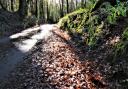
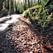
4) Go through this gate to join a broad descending track beneath the glorious, cathedral-like trees of Culm Davy Plantation. The track bends left where an area to the right has recently been replanted, but the majesty of the mature trees can be breathtaking; light and colours varying with the seasons.

Stay on this track, passing the supremely remote Little Thatch in about ¼ mile. Keep going; some of the surrounding woodland is coniferous, but this is a truly lovely stretch of walking.
Continue downhill until the track emerges from the woods, passing a house on the left. Keep ahead to join a lane, bearing right downhill. This meets another lane at a T-junction with a post box on the left; this hamlet is Culm Davy.
Go right and immediately right again, passing the entrance to Chapel Cottage. Head downhill on the lane and within 200m you pass a house and barn conversion on the left, followed by a cottage, Canters, on the right.

5) Follow the lane as it bends left and in just over 100m take a track on the right, signed as 'to public footpath' (the sign is several metres along the track). In 500m this bendy way reaches a T-junction with a lane. Turn left and in 160m you reach a footpath going right. Take this, admiring the quirky post box.
This track bends right then left as it heads to Pithayne Farm, and at the left bend the path has been clearly diverted.
Go right, as directed, leaving the track through a metal gate and walking up the field with the boundary to your right. In the top corner pass through the hedge then turn left to walk diagonally across the middle of the field.

This line leads to a metal gate leading onto a meeting of tracks. Keep ahead, crossing one track and walking up a short stretch of track opposite to reach a rather broken, yellow-arrowed stile in about 30m.
From here walk up the field beside the right-hand hedge; the buildings of Pithayne are over your left shoulder. In the top corner of the field don't go through the gate but bear left downhill, still in the same field and following the right hedge for just over 200m until you reach a double footpath gate on the right - here endeth the diversion.
6) Go through the two gates then bear diagonally left through the field to a gate down in the far corner.

Go through this and walk straight down the next field, hedge to your right. At the bottom turn right through a gate along an always muddy track. Join the lane and continue ahead past Pitt Farm.
Just beyond the farm buildings take the footpath directed left off the lane. Follow the track past barns on the left and a bungalow on the right. This leads through an ornate gate into the field.
Head straight across this long field to the far hedge, aiming to the left of a cream-painted house, Blackwater Cottage, in the distance.

When you reach the hedge seek out the arrowed stile that is tucked behind the corner of the hedge just above the bottom of the field. Cross this and walk diagonally across the next field to the opposite hedge.
7) In the far corner of the field emerge onto the lane and turn right, passing Blackwater Cottage on your left. Just beyond this join another footpath going left, crossing a footbridge and passing through a kissing gate into a field. Turn left and head for another gate a short distance away. Go through this and cross the field to reach the bridge which you can see spanning the River Culm.
Cross the bridge and bear right across the field to another gate, with Culmstock Church in the distance. Go through the gate and continue through the next field, passing a lone oak by a plank bridge. Keep ahead with the river to your right; this is a fine example of how the landscape has changed over time due to a meandering watercourse.

At the very end of the field, don't cross the footbridge but leave the field through a gate. Ascend steps and turn right towards the church tower.
Go through another gate and follow a narrow path between pretty cottages. This path joins the lane, keep straight ahead passing the church on your left and you find yourself back in the centre of Culmstock.
Directions to start: Culmstock is about 8 miles north east of Cullompton and can be accessed off the A38, along the B3391
Parking: On road in village - with consideration for residents
Start Point: Culmstock Village War Memorial on The Cleave. Post code: EX15 3JH. Grid ref: ST101136
Public transport: There are occasional buses, see travelinesw.com
Map: OS Explorer 128, Taunton & the Blackdown Hills 1:25 000
Terrain: Tracks, woodland and field paths, sometimes very rough and muddy underfoot. Some road walking. Wooden footbridges and stiles on this walk can be treacherously slippery - take care
Distance: 6 miles (9.5km)
Dog friendliness: Animals likely to be grazing - in fields and possibly around the beacon
Exertion: Moderate to strenuous - it is a steady ascent to the beacon
Refreshments: The Strand Stores, Culmstock, EX15 3JY (01884 840232); Culm Valley Inn, Culmstock, EX15 3JJ (01884 799823)
From Circular Walks in East Devon, one of a selection of West Country walking guides from Simone Stanbrook-Byrne and James Clancy. Others include: Circular Walks in Central Devon, Circular Walks in South Hams, Circular Walks in North Devon/Exmoor, A Dozen Dramatic Walks in Devon, Favourite Walks in Devon, Town Walks in Devon. culmvalleypublishing.co.uk / 01392 881513