This scenic walk by the water at Bretherton passes some important historic sites.

This walk was published in November 2019, so the details of the route may no longer be accurate, we do advise these articles should only be used as a guideline for any potential route you take and you should double check an up to date map before you set off.
Having previously described a walk from nearby Tarleton and followed the Leeds-Liverpool Canal (Rufford Branch) to its sea lock on the River Douglas, and then the Douglas to the River Ribble and the sea, I thought it would be interesting to explore the canal and Douglas in the opposite direction from Tarleton towards Sollom. I wanted a circular walk as usual, so plotted a route from Bretherton. It proved to be scenic and very historically interesting.

1. Leave the Blue Anchor car park and turn left and follow South Road until it reaches the war memorial then turn left down Eyes Lane and follow this as it turns right at its junction with Back Lane. Keep on Eyes Lane until it turns sharp left and at this point leave Eyes Lane and keep straight on, following a track to a T-junction close to the impressive Bank Hall that is being refurbished. Turn right and follow the track to where it joins the A59 then turn left and follow the A59.
Note: Bank Hall is a Jacobean mansion and is truly impressive even while it was being refurbished.
It was built in 1608 with further extensions added later. It was vacated in 1972 and allowed to deteriorate and eventually was vandalised.
This could have eventually led to complete collapse or demolition but The Friends of Bank Hall and Heritage Trust for North West and Lottery Funding have raised enough money for a complete restoration.

In 1969 the house was the location for the film The Haunted House of Horrors.
2. It is worth stopping at the Tarleton and Canal bridges as Tarleton Bridge crosses the River Douglas and Canal Bridge crosses the Leeds and Liverpool Canal (Rufford Branch), and you'll see a fine example of an original canal warehouse here.
Keep on the A59, passing the lovely St Mary's Church on the left. Note: St Mary's Church is unique and is virtually as it was in 1824 when the front porch section was added to the original church that was consecrated in 1719. It has no running water, no electricity, and no heating.
It still holds the occasional service and one was being planned as we walked by. We were lucky enough to go in to see the amazing interior.
3. After passing under a road sign turn left into Back Lane and follow this and keep on until it re-joins the A59 Liverpool Road. Join the A59, then turn left then after a few yards bear left into Liverpool Old Road and follow this into Sollom village.
4. At the red post box, turn left into Lock Lane and follow this down to the canal bridge by the old canal lock.
Note: Think back to Tarleton and the Canal Bridges at 2. The River Douglas is not in its natural original channel but in a purpose built channel from Tarleton Bridge to Rufford.
The canal however utilises a section of the original course of the River Douglas from Canal Bridge to the old lock at Sollom. Originally, before the Leeds-Liverpool canal was built, the River Douglas was navigable to boats all the way to Wigan from Tarleton via a series of 13 locks. The section of canal from the old lock at Sollom to Rufford was built in 1760 to bypass a poor section of the Douglas and from Rufford the Douglas Navigation as it was called carried on to Wigan. Evidence of the old course of the Douglas can be seen near the old lock at Sollom.
The Leeds Liverpool Canal Company eventually bought the Douglas Navigation and joined the Rufford end of the bypass canal to the main Leeds-Liverpool Canal at Burscough and diverted the Douglas at Rufford into the channel running to Tarleton Bridge.
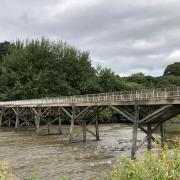
5. Cross the bridge and keep on the track and follow this. The track forks but a metal barrier blocks the track straight ahead so keep following the track as it goes left and on to Red Bridge.
Note: Red Bridge is a military type of bridge called a Bailey. These are designed to enable armies to establish bridging points on rivers and can be assembled in kit form easily and quickly. Red Bridge was built by the Swedish Army and put in place as the original bridge was demolished due to safety concerns.
6. Cross the bridge and immediately turn right and follow the footpath with the River Douglas on the right, then keep on the footpath as it turns left and follows the River Yarrow now on the right. Cross a stile by a metal gate then keep on towards Lostock Bridge and cross a stile by the bridge to join the road.
7. Once over the stile, turn left and follow the road and as it bends sharp right keep left and join Back Lane. Follow Back Lane and then take the first turning right into a narrow lane with a sign saying 'unsuitable for motor vehicles'. It is in fact Sarah Lane but the road sign is further on. Keep on Sarah Lane as it turns right then enters a housing estate. Keep straight on through the estate and join South Lane and turn right and follow this back to the Blue Anchor.
COMPASS POINTS
Start/finish: Blue Anchor, South Road, Bretherton.
Distance: 6.25 miles/10.06 km
Terrain: Really easy walking throughout on road, tracks and footpaths. Light walking shoes or boots will be fine.
Time: Three hours.
Facilities: No public toilets on route.
Map: OS Explorer 285 Southport and Chorley.


