
Discover outstanding beauty and a legendary beast on a circular walk along St Edmund Way and the Stour Valley Path

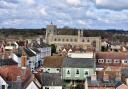
On the southernmost tip of Suffolk, straddling the Stour, Bures is an unusual beast. On one side, Essex claims the station and a small castle motte at nearby Mount Bures.
On the Suffolk side, St Mary’s vast churchyard wall sprouts deep Valerian pinks and warm orange hollyhocks to match the historic colour palette of a sizeable village which strangely retains the belittling title of ‘Bures Hamlet’.
Bures is a bit different in all directions and it is beautiful. Its church and manors benefitted not from wool trade wealth, but the largesse of the ‘Warring Waldegraves’, whose family made a pretty penny from 14th-century fisty-cuffs with France.

This is where the mighty 79-mile St Edmund Way and the 60-mile Stour Valley Path join for a relatively straightforward sortie via Sudbury to Long Melford.
But set off on a mini countryside crusade in the other direction, and a luscious loop will take you to new ridge-top heights and stunning Stourland views.
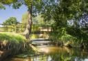
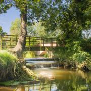
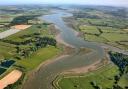
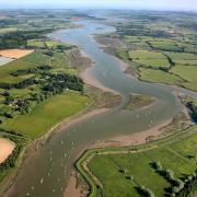
Ride the swells of Suffolk’s ancient rolling farmland as you surf up towards Arger Fen’s late-spring waves of bluebells. See the landscape cascade away as the path tumbles, trickling down the gulley to the Stour’s lazy bed at Wissington.

Then turn tail and wriggle back along the ridge on the southern side of the river. After the Essex village of Wormingford, you eventually snake back through the water-meadows of Bures.
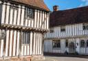
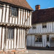
Starting in the village car park on Nayland Road, head for St Edmund Way. Past Fysh House, with its big Georgian windows, and tucked away around the next corner, is tiny St Stephen’s Chapel, reputed to be where Edmund was crowned king in 855AD.
St Stephen’s is hugely intriguing and almost feels like a folly. Thatched, half-timbered in places, with lancet windows, the exterior definitely looks the ancient part.

Inside, the walls have enough anti-witchcraft symbols to cause a spectral pile-up of gargantuan proportions. There are eye-catching snippets of original medieval glass and a tomb collection worthy of Westminster Abbey.
Divinely fascinating, it’s the legacy of Miss Isobel Baldock, who restored it after it had served for several centuries as a barn, farmworkers’ cottages, a mid-18th century plague hospital and a chapel, consecrated in 1218 by the Archbishop of Canterbury himself. It was only 700 years later that the early De Vere family tombs landed here in 1935.

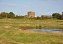
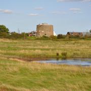
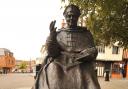
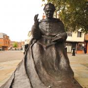
On the horizon, carved into the hillside, the ‘Old Bures Dragon’ was created by descendants of the Waldegraves, who entertained Elizabeth I at nearby Smallbridge Hall in 1561.
It marks Elizabeth II’s Diamond Jubilee and recalls a legendary local beast – be it ‘worm’, dragon or cunning croc’ – which gobbled up as many virgins as the neighbourhood could muster at the time. Fortunately it was well before the Virgin Queen was in town.
They say it moves, winging its way to Wormingford Mere. The original probably swam there – possibly an escaped crocodile from Richard I’s Tower of London menagerie which paddled up the Thames in search of tasty titbits.

Back on the St Edmund Way, across the tiny tributary and a climb to High Fen (well, 67 metres). There are beautiful shady rides along Dead Lane and grassy green paths, vintage oaks and tracts of bluebell woods near Wissington Grange. Some say the dragon-beast was slain here, put to death by knight in shining armour George Marney, of Layer de la Haye.
It’s a quintessentially English spot – very green, fresh and pleasant. No wonder one of our first women doctors, Dr Jane Walker, a pioneer of open-air treatment of tuberculosis, chose to build her sanatorium nearby.
The footpath channels its way down towards Wissington and yet another conundrum. Locals call it Wiston. The dragon pops up again, this time in a 13th-century wall painting inside the adorable little church.

Passing Wiston Hall – a bemusing John Soane ‘hunting box’, commissioned by the Bank of England’s Governor in 1791 – you wave farewell to Edmund and embrace Essex along the Stour Valley Path.
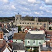
On the steep climb, you can see Little Horkesley Church ahead. If you turn, Suffolk’s Stoke by Nayland is perched high across the valley and the flag on St Mary’s waves back at you.
Topping a modest 50 metres, you’re soon walking the Wormingford ridge towards ‘Bottengoms’, the home loved by Akenfield author Ronald Blythe, and iconic artist John Nash, who lived there before him.
Nash saw his paintings as depicting “the Suffolk and Essex highlands”, lithograph scenes or woodcuts, tracing the vibrant swings and smooth curves of the landscape where he found solace after the difficult war years.
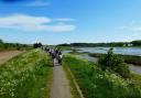
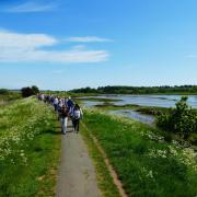
Here, a faintly trodden track across tufty meadows, there, an inviting stile to clamber into the next colourful scene. The Stour Valley Path shares its ups and downs, putting everything into beautiful perspective.
At Wormingford Church the dragon rears his crocodile head in a post-war memorial window, appearing well miffed as his feast of maidens is rudely interrupted by George’s lance.
The picture blends real with romantic, setting the tone for the kissing-gate-strewn descent to the emerald Stour floodplain. Regardless of its demon, this is a timelessly beautiful, healing sort of place.

Information
Distance: 11.25 miles/18 kms
Time: 5 hours
Start: Community Centre, Nayland Road CO8 5BX .
Parking: Bures car park, Nayland Road CO8 5BX
Access: Green lanes, field-edge, cross-field footpaths, some tarmac roads, pavements. Kissing gates, field gates. Steps, stiles, footbridges.
Must-have map: OS Explorer 196
The walk
1) Start at the village car park Nayland Road (CO8 5BX). Head right, out of town. At end of houses, turn left up road marked ‘Leading to Claypits Ave…’ and St Edmund Way (SEW). Continue straight ahead as the road turns to track. Pass community orchard/wood. Turn left along the track to the road.
2) Turn right. At Fysh House Farm sign take footpath right.
3) Permissive path right off SEW to St Stephen’s Chapel/views of hillside dragon. Regain SEW.
4) SEW is a farm track near Over Hall Farm. Turn left onto Assington Road (Arger Fen Nature Reserve access along the road). Left along Dead Lane (track), becomes road leading right.
5) SEW goes left along the gulley (or take the road ahead to view Jane Walker Park on left. Retrace steps).
6) At the junction, turn right onto the road, but keep straight ahead when the road becomes track towards Wiston Hall/church.
7) Wissington Church. Take SEW past Wiston Hall.
8) Leave SEW to go over the footbridge, following Stour Valley Path (SVP) signs from this point onwards.
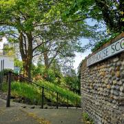
9) Bottengoms Farmhouse, where John Nash painted ‘The Barn, Wormingford’ and ‘Garden in Winter’.
10) Wormingford Church. SVP goes through the churchyard.
11) At the new building Wormingford Pumping Station, look for a cross-field path (SVP sign may not be in evidence!) to hedge the gap.
12) At the mill pond, the path goes right alongside Bures Watermill (signed SVP/ ‘Footpath to Bures’). SVP past front of Nether Hall, across meadow and recreation ground to meet Nayland Road by Community Centre.