There is change afoot in Chelford, but this month’s walk takes Howard Bradbury through some landscapes of timeless beauty.
Strolling through Chelford, I glimpse a couple of heavily-laden tractors waiting at a junction while a sleek orange Lamborghini rumbles by.
Had I been quicker with the camera, I could have snapped a rather telling image of life in rural Cheshire. There are farms...and there are Ferraris, livestock and Lamborghinis.
Chelford is one Cheshire village where the county’s farming heritage is more obvious than most. But it’s a little less obvious now than it was in the very recent past. The livestock market on March 30 was the last, the end of a tradition stretching back more than a century.
Wright Marshall auctioneers’ are moving the Chelford business to their other centre at Beeston, the firm expressing ‘bitter disappointment’ that their lease in Chelford is up. A planning application for housing on the market site is expected.

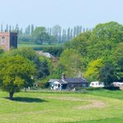
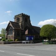
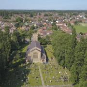
We pass by the market site at the start of this walk. Take heart that much of what we see on the rest of the walk seems unchanged by the centuries. We yomp across some muddy fields (close encounters with cows are unlikely, cattlephobes). We admire a church, St John’s, which has been ministering to the villagers’ spiritual welfare since the late 18th century. In the graveyard, you’ll find the last resting place of Reg Harris, five-times world champion cyclist and double silver medal-winner at the 1948 London Olympics. Aptly, Chelford is also home to cyclists Jason and Laura Kenny, with a joint tally of ten Olympic gold medals.
And you could round off this walk with a snack from a corner shop which has been in business since 1705.
The Walk

1. Let’s use Chelford Station as a starting point, postcode SK11 9AX. The station car park is for rail-users only, but there is some on-street parking in the area. Start walking along Station Road, away from the station, and turn immediately right into Dixon Drive, bearing right again to walk beside the former cattle market premises. Just before the road comes to a dead end, take the path to the right beside a house. This will take you under the railway – ankle deep in mud when I did this walk – through a kissing gate and beside a field.
Keep to this path until it emerges at the old Chelford school house, now business premises. When you reach Alderley Road, turn left, and a couple of minutes later cross over and take the kissing gate on the right into fields. Aim for the big oak tree on its own.
2. At the tree, go through the kissing gate to the left and follow the fenced path as it passes beside lakes formed from sand pits. Keep on this path as it takes a sharp right turn and winds round to a wooden gate, then cross over a muddy quarry track and through another wooden gate into a path beside woodland. There are copious signs here telling you to stay out of the quarry workings.

Eventually, you reach a metal kissing gate leading to an unmade track, Stubby Lane. Bear right up the lane until you reach the A537. Go right here, cross the road and take the footpath along the lane on the left signposted for Astle Farms.
3. Look up at this point and you should catch a glimpse of the Lovell Telescope at Jodrell Bank. After crossing a bridge over a brook, bear right along a lane beside the brook and, just before you reach a white house, go left through a metal kissing gate and along the edge of a field. Head towards St John’s Church in the distance, crossing several fields. The path emerges at the church car park. At the A535 turn right up the road.

4. The road passes over a brook and brings you to a roundabout where you will find Chelford Corner Shoppe, which, as a sign outside proclaims, was opened in 1705 and is still serving the community. I stopped here to refuel with what turned out to be a very superior meat and potato pie.
From the shop, bear left down Peover Lane and after a few minutes, look out for a bridleway on the right, beside some mature trees. This will take you beneath the railway again (a low brick tunnel which was also very swampy on my visit). When the path meets a lane, keep going ahead, then hop over a stile on the right to take a footpath along a right hand field edge. Keep going in the direction of the main road, and when you reach it, turn right to return to the station.
Compass Points

Area of Walk: Chelford
Distance: 4 miles
Time to allow: 2 hours
Map: OS Explorer 268
Refreshments: Chelford Corner Shoppe, Peover Lane, SK11 9AJ; The Egerton Arms, Knutsford Road, Chelford SK11 9BB
Chelford lies in between the popular Cheshire locations of Knutsford, Macclesfield and Alderley Edge.


