Head to one of Cheshire’s nicest areas for a rural ramble which offers a glimpse into our industrial heritage.
Go back 130 years or so, and life was decidedly grim for the residents of what is now one of Cheshire’s most desirable postcodes.By the late 19th century, Poynton had over 70 coal mines, providing filthy and back-breaking toil to around 700 locals. What had previously been a largely agricultural economy was transformed. The industrial revolution needed coal, and Poynton had ten coal seams, rising up towards Lyme Park. There had been mining as long ago as the 1580s, but with the coming of the Age of Steam, coal mining here began in earnest.
In the 1880s and 1890s, the landowning Vernon family saw 250,000 tons a year extracted from their estates around Poynton. The railway meant this bounty could be transported easily to the factories of Stockport, or the canal would take it to the big cotton mills of Bollington and Marple, or the silk mills of Macclesfield. This fascinating history is told in displays at Nelson Pit Visitor Centre, which you will see at the start of this walk. You will walk along the Macclesfield Canal, where, in the canal’s industrial heyday, bulk-laden horse-drawn barges would pass by at a rate of one every ten minutes. You will cross over the cycling and walking route, the Middlewood Way, which was once the rail line from Marple to Macclesfield. And if you still thirst for more industrial heritage by the end of the walk, you can stop in at Anson Engine Museum.
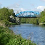
1. There is a pay and display car park at Nelson Pit Visitor Centre on Lyme Road, Higher Poynton SK12 1TH, charging £2 for 1-3 hours - more than enough for this walk. Or there is limited free lay-by parking nearby on Shrigley Road North, beyond the Coffee Tavern. Walking out of the entrance to the visitor centre car park, head left up Lyme Road, and when you reach the canal soon after, join the towpath and head right, under bridge 15. Continue for quite a few minutes until you reach the black metal lattice-style bridge 16. Don’t pass under the bridge, but turn right off the towpath just before it, then right again onto the path running parallel to the towpath and in the opposite direction to the way you have just come.

2. The path soon veers left and downhill away from the canal. Follow it downhill as it emerges onto an unmade road, passing a white cottage. Just before you reach an old stone building to the right of the track, look for a black sign pointing right for Higher Poynton. Follow this beside a large fir tree, down steps and ahead over a bridge. Continue on this path through woods, crossing two bridges, then up steps, emerging on the drive to a house called Hideaway. Head left to reach the road, then turn left. Almost immediately on your right you see Middlewood Way. Cross over to go through the clearly-marked entrance gate to Poynton Coppice. The path forks almost immediately. Stick to the right hand path, signposted Ward’s End.
3. Reaching a kissing gate, stay ahead and after a while, you reach a memorial bench at a viewpoint. Continue until this path meets a tarmac lane. Head left down this lane, skirting a five-bar gate and passing several houses before the track goes downhill. At the next collection of houses, look for a narrow fenced path next to number 5. Up the path, you come to a stile into a field. Head diagonally right up this field to find another stile. Cross straight across the next field where a little bridge and stile bring you to another field. Stick to the right edge of this field, bringing you to a stile and a narrow path to the road.

4. Cross the road and take the narrow - and possibly very overgrown path - path between houses directly opposite. The path widens beside allotments. Continue to a gate where you go right up the hill, then a few yards later left through an old kissing gate. There are three footpath options signposted; take the one straight ahead, with the fence to your left and trees to your right. The path bends right and uphill. At the top of the hill, ignore the first stile and footpath on the right and continue a few yards to a metal kissing gate.
5. Through the gate, cross the next field keeping to the right edge, and through the next kissing gate head downhill on a gravel path to the road. Head right up the road, passing Anson Engine Museum and you will arrive back at Nelson Pit Visit Centre in a few minutes.

Compass points
Area of walk: Poynton
Distance: four miles

Time to allow: under two hours
Map: OS Explorer 268
Refreshments: The Boar’s Head, 2 Shrigley Road North, SK12 1TE; The Coffee Tavern, 4 Shrigley Road North, SK12 1TE


