

This coastal ramble takes in the well and shrine of St Wite, Dorset’s patron saint, before scaling the slopes of Golden Cap, the highest point on the south coast of Great Britain, which offers breath-taking views along the Jurassic Coast over Dorset and East Devon
The 13th-century shrine of St Wite (St Candida in Latin) is housed in the Church of St Candida and Holy Cross at Whitchurch Canonicorum. St Wite was a Saxon saint believed to have been martyred by Vikings during a raid on Charmouth in the 8th or 9th century. St Wite is the patron saint of Dorset, and her feast day on June 1st is now celebrated at Dorset Day. Known for healing powers, St Wite’s stone shrine, inside the church, has three oval apertures where pilgrims could insert diseased or arthritic extremities needing a cure. Inside the 13th-century shrine, a lead reliquary inscribed ‘Hic requescit reliquie Sancte Wite’ contains St Wite’s remains, one of only two shrines in England to still contain the bones of a saint. On this rewarding walk, St Wite’s Well is encountered on a field track between Morcombelake and Stanton St Gabriel.

Stanton St Gabriel is mentioned in the Domesday Book of 1086 as land owned by the Count of Mortain. Farming created the landscape of trackways, hedges and fields that still feature today. The Chapel here was closed in 1540 at Henry VIII’s Dissolution of the monasteries. In the 1600s, 23 Stanton St Gabriel families petitioned for its re-instatement because they were having to walk three miles over hills and tracks to Whitchurch Canonicorum, and back again, every Sunday. The petition failed, and the Chapel eventually fell into ruin. In the 1700s, hamlet families were struggling to earn a living, so many went to work in Bridport’s rope and net trade, and the settlement was all but abandoned. St Gabriel’s House is 18th-century, restored by the National Trust and converted into holiday apartments.

The Walk
1 From the pay machine, double-back right to the footpath-gate. Through, follow the woodland track along the hillside, soon sweeping left. Through the right trees, see Hardown Hill and the A35. Reaching the ‘Golden Cap ½’ sign-post, take the ‘Langdon Wood Walk’ right fork.

At the next sign-post, take right ‘St Gabriel’s ¾’. Through the kissing-gate, walk down the field with views forward to Lyme Regis and Chardown Hill and right to Hardown Hill above Morcombelake. The bottom hedge gate opens onto Filcombe Farm’s lane, but don’t go that far. Turn right onto the green track coming from the left hedge’s gate. Over the field, go through the corner-gate into Muddyford Lane.

2 Turn left. In 10 yards, take the right footpath kissing-gate. Walk half-right down the field to the hedge’s footpath-gate. Through, go straight across, aiming at first for the hill-top farm shop, and down to a marshy area. Go through the footpath-gate onto the rising wilded-track between two fields to the fence’s corner. Turn right to the nearby footpath-gate. Through, follow the narrow path through verdant growth into a field corner with two paths. Go left, still narrow and verdant, to the footpath-stile onto a workshop track. Walk up the drive between houses and behind former Moore’s Biscuits bakery (now at St Andrew’s Road, Bridport). Emerge onto the A35 at Morcombelake.

3 Turn left. Visit the new (1841) St Gabriel’s Chapel with its 13th-century font from Stanton St Gabriel hamlet’s Chapel, we’ll visit it later. Pass left Shedbush Lane, right Gibbs Lane, left bus-stop and pedestrian crossing. Take Ship Knapp lane. Walk up past the right house and the left Georgian house with a mansard roof. In a few yards, signed ‘Stonebarrow Hill and Charmouth’ straight on, fork left onto ‘St Wite’s Well 1’ track. Follow the track to the gate signed ‘National Trust. Cattle grazing. Close the gate’. Through into the field with Chardown Hill right, St Wite’s Well is wooden-fence enclosed on the left bend.

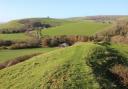
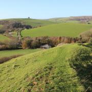
4 Through the next gateway into trees, pass the right ‘Chardown Hill and Stonebarrow’ stile. Continue for ‘Pickaxe Cross’ and ‘St Gabriel’s’. Past a left white cottage, meander down under trees, passing another left house. See Golden Cap through left trees and glimpse the sea through pines on a left bend. Golden Cap dominates the view as the track steepens to a crossing with Muddyford Lane left and a track right. Cross into National Trust St Gabriel’s track, continuing downwards with Golden Cap getting closer as the track meanders into a half-concrete track at ‘No Parking’ and bridleway-sign. See Chardown Hill back right across the field. Meandering down again, see Golden Cap looming above Great Gable. Past right ‘St Gabriel’s Cottage’ gate and left footpath-gate, ascend past left ‘Langdon Hill Car Park 1¼’ gate.


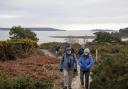
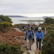
5 Emerge into Stanton St Gabriel green, formerly a busy hamlet where people made their living from fishing and farming. Bear left at the ‘Golden Cap and Seatown’ sign-post. Up the track, go through the bridleway-gate and explore St Gabriel’s Chapel. Continue up to the next gateway. Through, turn right for ‘Golden Cap’ and follow the long green path up the steep field towards the skyline sign-post. Arriving, join the South West Coast Path, go through the kissing-gate and climb countless steps up the flank of Golden Cap, 191 metres high, admiring the views west on the way.


6 On the top, capped with Upper Greensand, the low flinty domes mark bowl barrows that were excavated by the National Trust’s archaeologists in 2011. They discovered that the barrows were built entirely with chert fragments from Golden Cap’s own chert beds.


After admiring the views east past Seatown and Bridport and west to Lyme Regis and Devon from the highest point on the south coast of Great Britain, pass left Earl of Antrim’s memorial stone and continue along the eastward path, forking either left or right, to the O.S. 191m trig point with Seatown below.


Follow the rope-edged path/steps down into trees. Through the kissing-gate, go straight downfield for ‘Langdon Hill Car Park’. Through the corner kissing-gate, follow the right hedge across the valley field to 1½ bridleway-gates. Through, take the left kissing-gate for ‘Langdon Hill’. Up the path to ‘Trust 10’ junction, go right, rising to Langdon Hill’s woodland track, signed back ‘Coast Path Golden Cap’. Simply stroll along the track anti-clockwise around Langdon Woods for ½ mile to the car park where you started.

Compass Points
Distance: 4¼ miles/6.75 km
Time: 4 hours
Exertion: Strenuous hill walking
Map: OS Landranger Sheet 193
Start: Langdon Hill National Trust Car Park, off A35 west of Chideock (Grid Ref: SY413930)
Public Transport: None, but Jurassic Coaster X53/X51 to Morcombelake
Dogs: On leads in fields with livestock, abide by The Countryside Code
Refreshments: Anchor Inn, Seatown for real ale and bar meals

Click here for a circular walk through Bronze Age Dorset at Winfrith Heath
Click here for 8 breath-taking Dorset walks with fabulous views