
Walk in the childhood neck of the woods of Harry Potter author JK Rowling and enjoy forbidden forests, romantic ruins and stunning cliff-top scenery along the Wye Valley

JK Rowling’s Gloucestershire roots are evident from the very first sentence of Harry Potter and the Philosopher’s Stone: ‘Mr and Mrs Dursley, of number four Privet Drive, were proud to say that they were perfectly normal, thank you very much.’ Born in Yate General Hospital in 1965, Joanne Kathleen Rowling (as she was back then) lived in a couple of locations around the county as a child.
At one point her family dwelled in Winterbourne, now in South Gloucestershire, where she had friends next door whose last name was Potter. Her parents moved to Tutshill when she was aged nine, and she attended the Primary School there and Wydean Comprehensive School at Sedbury, overlooking the Severn (the start or end of the Offa’s Dyke Long Distance Footpath) from the age of eleven – the same year Harry Potter started at Hogwarts. Professor Snape was based upon the head of science there at Wyedean, the late John Nettleship (her mother, Anne, was a science technician in the Chemistry department).
Several scenes from the blockbuster film adaptations were filmed in Gloucestershire, including at Gloucester Cathedral and Symonds Yat. And, to clinch the JK credentials for the area, the author revealed on her Pottermore website that ‘the wizarding family of Potters descends from the twelfth-century wizard Linfred of Stinchcombe’, a small civil parish between Dursley and Nibley.
Walking around Tutshill and Tidenham one gets a real sense of Rowling’s childhood mythscape – the dramatic landscape of the Wye Valley that must her stirred her youthful imagination and manifested decades later in the world of Harry Potter. As we celebrate 20 years of ‘the boy who lived’ what better time to see where it all started? Excelsior!
Before you start, take a look at the map here.

The walk:
1.Park at Castle Dell carpark by Chepstow Castle. Here there are toilets, a Tourist Information Centre, pubs and a museum – so an excellent base for the walk.
2. Turn left out of the carpark. Heading north, cross over the magnificent Old Wye Bridge – it’s Victorian ironwork painted a handsome white. You have now left Wales. On the ‘English side’ head up the steep narrow lane signposted ‘Offa’s Dyke Path’ (look out the white acorn sign of a long distance footpath – this one runs 177 miles to Prestatyn on the north coast of Wales if you’re feeling athletic!).
3. Head straight up the lane. Ignore the path halfway up that turns right (that leads to the end/start of the Offa’s Dyke Path at Sedbury Cliffs). Continue up to the road (Castleford Hill), cross carefully, and continue up the green lane (Mopla Road).
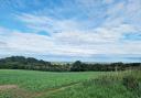
4. Take the gate on your left and head north up the hill, crossing the field.

5. At the brow of the hill you’ll pass a house with the ancient Tutshill Tower in its back garden. ‘Tut’ is a local word for ‘watchtower’ and gave its name to the village.
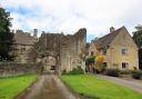
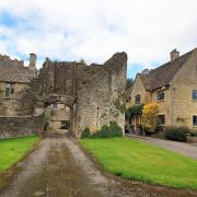
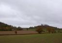
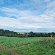
6. Keep following signs for the Offa’s Dyke, passing through a couple of metal gates and crossing a second field with views of a magnificent country house.
7. At the far end of the field you come to a stone wall. Set back is a wooden footbridge – go under...
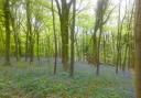
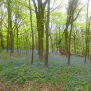
8. Drop down into Lancaut Nature Reserve, passing some impressive crags and the quarry. Spend a moment at the love bench.
9. Follow the footpath on its loop around the reserve – it snakes along the side of the Wye, dropping down – mind your step (this is wear walking poles and good boots will serve you well).

10. The footpath seems to end at what looks like a landslide – do not be alarmed! Scramble across this boulder scree and very shortly the path continues.
11. Continue on until you come to a bench by the river – sit and enjoy the views back along the Wye. If you’re lucky you may even see grey seals!
12. You will eventually come to a ruined church – once dedicated to Saint Cewydd – all that remains of a medieval village named after him (Llan Cewyddd became Lancaut).
13. Ascend up the steep path (mercifully, another bench awaits before the next push...).
14. Keep ascending through the forest. You’ll pass two limekilns.

15. At the brow of the hill you emerge from the trees as you reach Lancaut Lane. Follow this right back towards Chepstow. You’ll pass a carpark with a peregrine falcon wooden carving.
16. At the B4228 turn right. Follow it down – be careful of traffic. Cross at take the grass verge as it bends left.
17. Continue to Woodcroft.
18. Continue along the road until you come to Wintour’s Leap, set back from the road on the right. This affords fabulous views over the Wye – it is named after a Sir John Wintour, a Royalist, who, fleeing his Roundhead pursuers, made a daring escape down the steep gorge. The quarrying has made this more precipitous than it used to be in the time of the Civil War, nevertheless, a heroic feat, but not one to emulate!
19. Follow the Offa’s Dyke Path as it runs along the back of the cottages and the top of the quarry – but don’t look down!

20. The OFP comes out by an old ‘medieval times donkey path’.
21. Go right – follow Coleford Road into Tutshill.
22. Just before the charming church of St Mary and St Peter you’ll pass Church Cottage, the childhood home of JK Rowling. Be mindful this is a private residence if you take any photographs.
23. Shortly after this you will reach the Church of England primary school – imagine a 9 year old JK Rowling attending here...
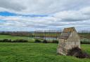
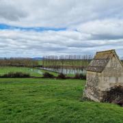
24. Keep following the Coleford Road down towards Chepstow, passing a well-maintained WI shelter with bookstall and information.
25. At the Live and Let Live Pub, leaving the Coleford Road, take Mopla Lane right down the hill. Note on your right an old sign on garden wall of a cottage informing us that ‘On this site, Sept, 5. 1758, nothing happened’ there!
26. Continue downwards (passing the gate you went through up the hill to Tutshill Tower) back to the bridge ...
27. Cross the Old Wye Bridge, enjoying splendid views of Chepstow Castle.
28. Here you can turn left along the riverside to the lovely Boat Inn, where you can sit outside (in good weather) and enjoy the view back across to the English side. You can then rejoin the route – either by retracing your steps to the bridge or cutting through the park and turning right at St Anne Street.
29. Passing The Bridge Inn, ‘the first and last pub in Wales’, continue up Bridge Street towards Chepstow Museum – free and well worth a visit.
30. Top marks! You’ve made it back to Castle Dell carpark. Time for a game of quidditch or a ginger beer?
Need to know:
Distance: 6.92km / 4.30ml walk
Level: Moderate. NB Steep paths/scrambling over rocks in one short section. Suitable footwear essential. Walking poles advised.
Time: 2 hours.
Pub: The Boat Inn, Chepstow. The Back, Chepstow NP16 5HH Tel: 01291 628192
Dog-friendly: Yes.
Public transport: Rail and bus links to Chepstow.
Parking: Castle Dell Carpark (free on Sundays).
Toilets: Castle Dell Carpark.