This month’s walk by John Lenehan starts and finishes in a lovely market town surrounded by glorious countryside

This walk was published in September 2015, so the details of the route may no longer be accurate, we do advise these articles should only be used as a guideline for any potential route you take and you should double check an up to date map before you set off.
Everyone should visit the busy, bustling and very picturesque town of Kirkby Lonsdale. It sits on the spot where Lancashire, Yorkshire and Westmorland meet and has some lovely architecture and is surrounded by glorious scenery.
There is also an abundance of quaint, independent shops and a great selection of quality cafes and good pubs and restaurants that cater for all tastes. A butty to a banquet would be a good sum it up. It also nestles in the very beautiful Lune Valley and offers great walking. This walk, the Kirkby Lonsdale loop, takes in a bit of that beauty.
1. Leave the market square and proceed up the hill of New Road. At the T-junction turn left then at the road fork take the left fork. Level with the Free Grammar School there is a footpath sign on the left, follow this. Cross the main A65 road and go through the stile facing on the opposite side. Cross the rugby pitch and then, crossing two fields and two stiles, reach Wood End Farm. Turn right as you reach the farm to a stile on the left. Go through the stile and then right along a short track to a white cottage.
2. A footpath sign directs you left in front of the white cottage to a very narrow footpath that passes between two stonewalls then becomes very rough and stony underfoot. Ignore the gate on the right as you go down hill and the path becomes part of a streambed. It may feel wrong but keep following the stream until a path breaks slightly to the right and keep on down to a stile by a wooden building. Cross this and into a yard then turn left towards the building of Sellet Mill.
Note: The stream you have been following is the feeder to the old mill pond of Sellet Mill. The mill is the three storey building facing the main road and it is easy to walk past it without really noticing that it still has on its left hand side a waterwheel. The mill dates back to around 1664.
3. Join the main road and turn right and follow this all the way to Whittington. The main road bears left through the village, follow this and until the end of the village is reached.
Note: Whittington was the birthplace of William Sturgeon in 1783. He invented the electro-magnetic motor.
4. As you leave the village, the main road bends sharply right. In the centre of the bend a track goes left. Follow this track past a disused tennis court on the left and all the way down to the riverbank.
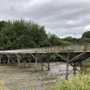
5. Reach the riverbank and turn left by a wooden hut and follow the River Lune heading upstream. The path follows the river all the way back to where the A65 crosses it over a large bridge. Walk right up to the bridge and there is a stile to the left next to the bridge wall. Go through the stile and then up the banking and then right crossing the A65 to a stile directly opposite and then turn right down toward the river and pick up the path that goes left to Devil's Bridge.
Note: The history of the name Devil's Bridge instils a feeling that this must have been a place of fear. In reality it was built in the 14th century possibly by monks as it is on one of the old ecclesiastical routes between monasteries. The story goes that the devil offered to build the bridge in one night if he could have the soul of the first one across. An old woman being a bit more crafty than the devil sent her dog across first. The devil was so angry he disappeared in a cloud of smoke never to return.
I don't know if there are quite as many motorbikes anywhere else in the UK other than Devil's Bridge at weekends and Bank Holidays. Possibly the Isle of Man at TT week just beats it. This is a place for young men to dream and old men to drool at some of the fantastic machines on show.
6. Cross the stile at the bridge into the lane then turn left and go uphill passing the public toilets on the right.
7. When a path appears on the right, follow it and at the top of the hill turn left and follow the lane back to the Market Square.
Compass points
Distance: 5 miles / 8.05 Km
start and finish: Market Place Square, Kirkby Lonsdale.Map: OS Explorer 287 West Pennine Moors.
terrain: The walking is good most of the route but the first section is rough under foot and could be wet so good boots and possibly walking poles should be utilised. In summer there are a lot of nettles after Wood End. Other than that there is a section of road with no pavement so a bit of care is needed with oncoming traffic.
Map: OS Explorer 19 Howgill Fells and Upper Eden Valley.
Facilities: There are public toilets in Kirkby Stephen but none on route. Pubs and cafes are in abundance in the town.
Watering Holes
There are many cafes and pubs in Kirkby Lonsdale and all are good. Having tried nearly all of them at some time I really cannot find any criticism so I can only go on my personal preference and that is Plato's on Mill Brow in the town centre.
It could be mistaken for a trendy Tapas bar but it isn't although they do serve small plate dishes in a similar vein. The food is excellent with traditional dishes including the hot beef sandwich. This and a pint of real ale after a walk is heaven to me. Luxury accommodation is on offer and the full English may next time tempt me to stay over and enjoy one, that and some more real ale the night before.


