
Edward Griffiths explores a rugged landscape that retains echoes of Saxon fields and corn mills from its agricultural past
Long before the Isle of Portland became famous for its superlative limestone, the land was mostly agricultural and, in the 1851 Census, 45 men were still listed as agricultural labourers. The main crops were wheat and barley which grew well on the shallow, stony soil. Between Southwell and Portland Bill, there are remains of the Saxon strip farming system known locally as ‘lawnsheds’ (or ‘lynchets’) once common throughout Dorset. Because Portland’s inheritance laws favoured sons and daughters equally, the farmland became increasingly sub-divided and dispersed, so some people ended up owning hundreds of plots each no more than a few square yards in area. This explains why some of the fields are really quite tiny.
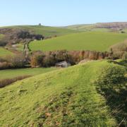
Two windmills for grinding corn were recorded by William Simplon in 1626, and we visit both on this walk. North Mill at Cottonfields and South Mill at Top Growlands (local field names) are listed circular buildings, constructed from rubble-stone, which were still working until the 19th century.
Information
• Distance: 4¾ miles (7.5km)
• Time: 3½ hours
• Exertion: Not strenuous. Gentle slopes, clear paths and town walking
• Start: Portland Bill Car Park (Grid Ref: SY667685)
• Map: OS Landranger Sheet 194
• Public Transport: First Bus 1 every 9 minutes from Weymouth
Dogs: On leads on roads
• Refreshments: Lobster Pot for teas and lunches, Pulpit Inn or The Eight Kings for lunches and bar meals
The walk
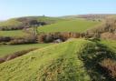
1 After discovering Portland Bill lighthouse, Trinity House obelisk and Pulpit Rock, start this walk from the Lobster Pot café. Walk up the centre of the large field, towards the Pulpit Inn, with white coastguard cottages on the right. Reaching the road, turn right into the ‘Public Footpath’ track with more white cottages. When these end, well before the ‘Private Beach Huts’ notice, fork left onto the field’s clear path, aiming at the Lower Lighthouse, now ‘Portland Bird Observatory’. Meeting the track before the lighthouse, turn left up to the road, signed back ‘Coastguard Cottages’. Cross over and turn right. Take the left ‘Sweet Hill ¾, Wallsend Cove ½’ fenced footpath-track.
2 Ascending between lawns, with the old Underwater Weapons Research Unit (now Southwell Industrial Park) ahead, the track bends right at a footpath-arrowed T-junction. The Napoleonic prison is ahead left. After a left bend, continue meandering between paddocks, small fields and a right kissing-gated open common. Past left Higher Southwell Farm, descend into Southwell with a ‘Wallsend Cove ½, Portland Bill 1½’ signpost. Turn right down Sweethill Road. At the T-junction, turn right into Sweethill Lane. Down to the triangle, keep right past older stone cottages then cross to the left side.
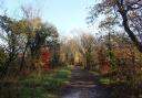
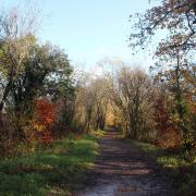
3 Pass left Church Lane, right Eight Kings pub and the ‘Portland Bill’ road. After left Cedar Drive and some old cottages with Victorian verandas, continue along Southwell Road’s pavement with the meandering stone-wall. Pass left Coombefield Quarry, right ‘Coast Path’ access points and Cheyne Weares Car Park. Here, cross to the grass verge for lovely views, including Rufus Castle and Church Ope Cove beach, as you walk. After left Weston Street and right Cove Holiday Park, cross over. Housing development has complicated original footpath routes off Weston Street so, continue past Pennsylvania Way to Perryfield Quarry’s left entrance, before the car park. Turn in and immediately take the signed footpath before the quarry gates. Follow the rock-edged path with quarry workings left. In 100 yards, when the quarry track bends right, bear half-left across the track to pass the right ‘West Cliff’ footpath-post. Follow the clear bending track, aiming for ivy-clad South Mill. Past the windmill, take the right-fork fenced-path, then fork left to pass right North Mill.
4 Meeting a crossing footpath-track, turn left along the pavement with right houses and left ‘lawns’, passing a footpath arrow-post. At right Laburnum House, emerge into a garage area. Turn left down Gypsy Lane, passing thatched High Croft Cottage, into Providence Place green, surrounded by cottages of all ages. In 100 yards, turn right onto the service road. Cross Weston Road into Isle Road with the left green. Round the right bend, take the signed left footpath between gardens. Continue with left lawns, aiming for the mobile phone mast ahead, passing a garage block and Grangecroft Car Park.
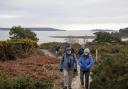
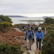
5 Meeting the Coast Path at West Cliff, admire the magnificent coastal views and turn left. Follow the Coast Path for 1¾ miles, passing lots of joining paths. From Southwell Industrial Park, the Upper Lighthouse comes into view, followed by Portland Bill and the Lower Lighthouse. Past the Upper Light and right Coastwatch Lookout Station, cross the drive and keep straight on down the field, crossing another drive from the right M.O.D. buildings, back into the Car Park where you started.
More walks…
• Dorset walk around Poole Bay and Evening Hill - Edward Griffiths enjoys an easy coastal stroll with sensational views towards Old Harry Rocks and then explores Canford Cliffs Village
• Dorset walk around Chetnole and Melbury Bubb - Edward Griffiths enjoys a leisurely stroll through Thomas Hardy’s ‘Vale of the Little Dairies’