Edward Griffiths revels in some of the finest views in England from Compton Abbas Airfield on this breathtaking north Dorset walk

• Distance: 5 1/4 miles (8.5 km)
• Time: 4 hours
• Exertion: Fairly strenuous with 630ft of total ascent. Some mud in woods after rain.
• Start: National Trust’s Fontmell Down parking area on Spreadeagle Hill, Melbury Abbas (Grid Ref: ST886187)
• Map: OS Landranger Sheets 183 and 184
• Public Transport: None
• Dogs: On leads in fields with livestock, on roads and where requested
• Refreshments: Compton Abbas Airfield Café for meals, lunches, snacks and coffee
***
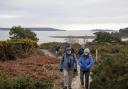
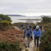
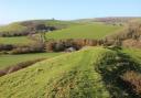
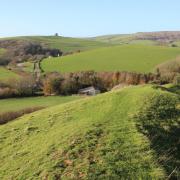
This glorious, if somewhat strenuous walk rewards your efforts with wonderful views. Along the way our route takes you through ancient woods and over sheep-filled chalk downs. We stroll above and through some of Dorset most picturesque valleys and visit the highest village in Dorset at 710ft. We’ll also visit an airfield with probably the best views in England and a cracking tea room as well. Route instructions are paramount, so just enjoy!
***
The Walk
1 From Fontmell Down car park, take the fenced Dorset Wildlife Trust (DWT) bridleway path alongside the road with Fontmell Down on your right and Compton Abbas Airfield left. Through the end half-gate, cross the signed footpath and follow the bridleway down the left fence, through trees and past a left gate to the DWT half-gate above impressive Longcombe Bottom. Follow the clear chalk path along the valley head and up into a hanging wood at a DWT-arrow. Don’t go down the track. Turn left up into the left-fenced track. Through the facing gate/stile, turn instantly left through the Conservation Walk half-gate. Follow the left fence up the field to the bridleway half-gate onto the road. Cross carefully!
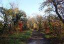
2 Through the opposite 1½ bridleway-gates into Fontmell Wood, don’t deviate from the next instructions. Ignore the right track and keep straight on, descending and bending right then left to join a track coming from your right. Down into the valley, meet a crossing and turn right down the valley track with grass up the middle. Reaching a T-junction, keep left along a left deer fence, still descending and passing a bridleway-arrow on a right tree. After fences both sides, the track swings right with Shepherd’s Bottom left. Continue to 1½ gates onto the road with backward bridleway and ‘Shaftesbury Road 1’ signs. Turn left and pass Washers Pit pond over the right corner fence.
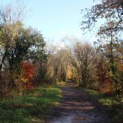
3 Don’t go through ‘Ashmore’ Forestry Commission barrier but go up the left-fenced steep bridleway path (painted arrow). Ascend slowly inside the top edge of Washers Pit Coppice for ¼ mile above the right forest valley. At the top, bending right, pass a left bridleway-gate into a field. Again, don’t deviate from the next instructions. In 100 yards, at a bridleway-arrow post, fork left on the un-arrowed path through coppice to the first of two bridleway-arrow posts. Don’t go as far as the second one. Turn sharp left at the first one (arrow on other side), rising slowly and passing two bridleway arrows, one on a right post, one on a right tree, onto a grass track with field left, Great Morris Close woods right. Continue past a joining right grass track. Sweeping right into the wood, there’s a field left.
4 When the field ends at a left gate and right track, keep straight on, past a tree’s bridleway-arrow, down the lesser path through coppice and woods. Meeting a track at a bridleway-post, go left up to a staggered crossing with low arrows-post. Turn left on the rising footpath out of the woods onto a high fields’ track. Reaching the tracks’ T-junction, turn left onto Halfpenny Lane for ‘Ashmore ½’. In ¾ mile, emerge through the end gate into Ashmore village, signed back ‘1 Ashmore Wood’. Turn left to continue the walk, but visit St Nicholas Church and the famous dew pond first. Past the footpath into Manor Farm Dairy, continue past the derestricted sign.
5 In 100 yards, take the right bridleway-gate into a fenced grass track between fields with deep Shepherd’s Bottom valley ahead. Through the end bridleway-signed gate, turn right along the fenced trees. In the field corner, turn left down the bridleway-signed right fence on the steep grass track and through a bridleway-gate. Through the bottom bridleway-gate and trees and across Shepherd’s Bottom, bend left and fork right up the grass track to the fence-gate. Through, continue climbing, against a right fence now, to the top corner gate into the next field. Keep ascending. Through another corner gate, follow the track along the inside edge of Fontmell Wood for ½ mile to 2½ gates onto the road, signed back ‘bridleway’ and forward ‘footpath’.
6 Over the facing hedge-stile, cross the enclosure to the footpath-stile onto the airfield. Looking and listening all the time for possible aircraft, hurry half-left across the airstrip, aiming right of Melbury Beacon, the highest point ahead. Meeting yellow pointers against the opposite hedge, turn left along the hedge to the footpath-stile. Over this, turn left along the track above right Melbury Down with super views to Shaftesbury. Reaching Spreadeagle Hill’s gate/stile with a backward footpath-sign, cross slightly right to the Melbury Hill gate, then turn sharp left and follow the fenced path back to Fontmell Down parking area where you started.
***
READ ON
• 4 of the best places for stargazing in Dorset - There’s not much better than a clear night sky, right? We’ve rounded up 4 Dorset Wildlife Trust Reserves perfect for stargazing.
• 10 of the best things to see and do in Sherborne - Greatly sought after as a film location, this charming north Dorset town offers a packed events programme, an impressive array of independent shops, superb schools, two castles, an abbey and an illustrious history.