
Edward Griffiths discovers the wilder beauty spots of Christchurch on this easy stroll through a salt and freshwater marsh nature reserve and along Avon Beach

• Distance: 5 1/4 miles (8.5km)
• Time: 4 hours
• Exertion: Easy level walking. Minimal puddles on marsh path.
• Start: Mudeford Quay (Grid Ref: SZ185918)
• Map: OS Landranger Sheet 195
• Public Transport: Wilts and Dorset X1, X2 and Yellow Buses 111
• Dogs: On leads in marshes and where there is livestock
• Refreshments: Lord Nelson for lunches and bar meals, Chip Shop on Stanpit, and the Noisy Lobster at Avon Beach

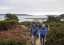
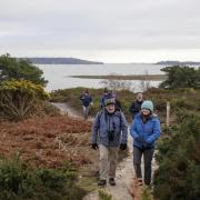
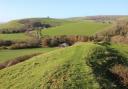
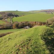
Stanpit Marsh is an outstanding local Nature Reserve on the north side of Christchurch Harbour, just below where the Rivers Avon and Stour meet. Stanpit Marsh, the highest point of which is Crouch Hill rising to an impressive 5 metres, is salt marsh, and Priory Marsh is freshwater marsh with reed beds. The marshes absolutely teem with a huge variety of wildflowers, grasses, butterflies, birds and reptiles.
Overwintering birds make their home here, so watch out for curlew, redshank, dunlin, lapwing and Brent geese on this walk, which circumnavigates the marshes. We also visit the fishermen’s dock at Mudeford Quay, where local fish and shellfish are landed, and visit Avon Beach with its views to the Isle of Wight across the water.
.
The Walk
1 Our walk starts at Mudeford Quay, at the end of the walk take some time here to explore this delightful part of Christchurch: buy some fresh fish, have a coffee and enjoy the view across Christchurch Harbour to Stanpit Marsh.
Leave on the car park drive along the left dinghy park. Follow the Tarmac path across the lawns and over the footbridge to the left fork exit road into ‘Mudeford’. Turn left and continue along the road (which becomes ‘Stanpit’ at All Saints’ Parish Church). Reaching left Coastguard Way, turn left. At the end, turn left/right on the fenced Tarmac drive. Through Number 15’s gate, turn right/left onto the ‘Footpath’ around a garage to the harbour side path. Turn right and follow the gravel path past right houses, passing a right road and several jetties. Reaching a 6ft wire fence, go through the gateway to the road, signed back ‘Footpath’. Turn left.
2 Past right Victoria Road, the left Girl Guides’ hut and left Tutton’s Well, take the left arrowed footpath into the car park. Walking left of the Scout Hut, follow the path past a cantilever-gate and through the Stanpit Marsh kissing-gate. Keep following the gravel path, opening out on the marsh, enjoying the views and the birds. Keep following the low posts, on a lesser sandy path for a while, then over the Bailey Bridge. These were designed and built at the M.O.D. establishment on Christchurch’s Barrack Road. Over the boardwalk, the fenced area to your left is Crouch Hill where an early Bronze-age barrow was excavated in 1921. Hengistbury Head is prominent ahead, before the track turns slowly around, becoming a pebble beach. Along the beach, look out for a faint path forking right. Follow it to a footbridge, beyond which there is a series of short boardwalks.
3 Ignore a left path to a stile into reed beds, just before a steel boat which is thought to have been beached here during storms some time between 1947 and 1963. Over another boardwalk, the path runs into scrub. Through the facing kissing-gate, turn left to a Tarmac path. Right takes you straight back to the Scouts’ car park, but turn left. Over a bridge, go through the left corner 1½ gates into a fenced path, with several information boards, around the golf course. This path is elevated and affords good views of Stanpit Marsh, Priory Marsh and Christchurch Priory. Through the end kissing-gate, turn right along the path with the left boat-park and ditch. Cross the private boat yard drive into the ditch footpath. Past the right car park and over the footbridge, walk past the Civic Offices and along the block-paved path to Bridge Street.
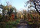
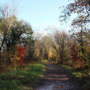
4 Turn left over the bridges to visit Christchurch centre, but turn right to continue the walk. Cross the Stony Lane traffic lights into Purewell. Pass Ye Olde Starre Inne and, in 200 yards, take the right signed ‘Public Footpath’ into Marsh Lane. Walk between walls, across a block-paved courtyard, along a fenced path, past Ashtree Meadows houses and onto a path between narrow marsh fields, under trees. Past a left kissing-gate and over a footbridge, meet a Tarmac path. Turn left. Ignore all turnings off and meander back to the Scouts’ car park. At the large cantilever-gate, the footpath arrow points diagonally across the car park, so leave through the corner where you came in from Stanpit earlier.
5 Walk along Stanpit, passing the Village Hall, Ledbury Road Cricket Field and Coastguard Way where you had a short harbour side stroll earlier, the Lord Nelson, and All Saints’ Church where Mudeford begins. Pass the Mudeford Quay car park exit where you came out earlier, and pass the Chichester Way entrance. Keep straight on. Reaching a left bend, becoming Bure Lane, continue to ‘Avon Beach’ with the Noisy Lobster beyond the car park. Turn right along the Tarmac drive or along the beach path. Past a right holiday park, arrive back on Mudeford Quay where you started and maybe stop off for that coffee you promised yourself!
***
READ ON
• 7 of the best farm shops in Dorset - Want to keep your food miles low and your taste experience high? Alice Cooke reveals some of the county’s best farm shops
• 10 restaurants in Dorset perfect for vegetarians and vegans - Sue Quinn, author of Easy Vegan, has rustled up a lip-smacking range of plant-based dining options in Dorset that are perfect for full or part-time herbivores