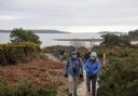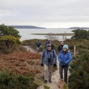

Edward Griffiths enjoys views of the River Stour in this easy walk between two pretty villages through the lush farmland of the Blackmore Vale.
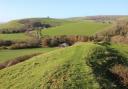
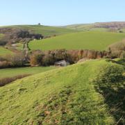
Meandering between two of the Blackmore Vale’s larger villages, this walk crosses fertile farmland with a few arable fields but mostly dairy with good grazing on the clay-rich soils. Take your time, enjoy the views and watch the meandering River Stour from the two footbridges. The route passes through Stalbridge and Marnhull, so you can browse the local shops or enjoy a meal before, during or after your walk.
Distance: 5¾ miles (9.25 km)
Time: 3½ hours
Exertion: Not too strenuous. Mostly level, several stiles; mud after rain around some gates.
Start: Stalbridge Car Park, Station Road (Grid Ref: ST737178)
Map: OS Landranger Sheet 183
Public Transport: First 58, 58a, 158,. Damory 330, 368
Dogs: On leads in fields with livestock and on roads
Refreshments: In Stalbridge - The Swan, The Crown and Stalbridge Arms. In Marnhull - Blackmore Vale Inn
The Walk
1 Leaving the car park, turn left up Station Road to High Street. Facing the Post Office, turn left. Reaching ‘The Ring’, fork left into Lower Street. Past the Stalbridge Arms, continue to Bibbern Brook bridge. Take the left footpath-signed stiled-bridge. Over, turn half-right to the field’s hedge footpath-stile/bridge. Over, cross to the footpath-stile/gate. Again, cross to another footpath-stile/gate. Over, pass the left paddock. Over the fenced track with stiles either side, cross to the fence footpath-stile. Over this, cross the field’s narrow end to the hedge-stile onto the now extinct railway line. Turn right along the hedge.
2 Reaching Hewletts Farm’s track, cross over. Go over the nearby left footpath-stile. Walk up the field, right of the second electricity post, to the footpath-gate into a concrete yard. Through the facing footpath-gate, pass left of the stone barn and between open-fronted barns to the footpath-gate into a paddock. Cross to the hedge’s footpath-gate. Through, cross to the footpath-arrowed hedge-gap, sighted between two oaks in the next field Through here, pass right of the oaks. Past the hedge-corner, follow the left hedge to the footpath-gate.
3 Through, walk straight across to the ditch-bridge/stile hidden in the opposite hedge. Over, walk straight across, or round the edge, to the new fence-stile. Over, cross to the stiled River Stour footbridge. Over this, the faint path passes the river’s edge to the hedge-gate. Over, follow the left hedge to ‘Common Lane’ gate. Walk straight on up to the Chantry Farm T-junction. Bear left. Reaching the right bend, turn left down the footpath-signed drive. Through the ‘Private’ gate continue down into the field’s edge.
4 Over the right-corner footpath stile, and another into a sloping field, follow the right hedge to the footpath-gate/stile. Over, turn left along the grass track into a concreted yard. Through, zig-zag left-right onto the ‘Stour Valley Way’ track with houses right. Joining a concrete drive, meander past stone walls and through Cross Tree Farm’s gate to Burton Street, Marnhull. Turn left. Past shops and Blackmore Vale Inn, turn left into Ham Lane. Continue until the tarmac ends. Go through the facing footpath-gap and follow the left hedge down. Through the left turning into the next field, turn right along the hedge to the footpath-stile/gate.
5 Through, bear left to the River Stour’s stiled-footbridge. Over, follow the nearby river to the facing hedge’s footpath-stile/bridge. Over, continue parallel to the river, over a possibly temporary fence-stile to the hedge’s footpath-stile/bridge, losing the river. Cross to the next hedge’s twin footpath-stiles. Over, walk through the long field to the distant hedge’s footpath-stile/bridge. Over, bear slightly left towards Triangle Farm. Through the left corner gate, cross the lane into the opposite lane. In 100 yards, take the right footpath-bridge/kissing-gate. Through, bear ¼-left to the kissing-gate onto the road. Cross into the footpath-signed yard.
6 Leave by the far corner’s footpath-arrowed bank into trees. Through to the footpath-stile, turn right along the field’s hedge to twin footpath-stiles. Into the next field, keep following the right hedge to the footbridge/stile into an enclosed path. Ignoring the left gap, keep following the fenced path. In the corner, go left down to the footpath-bridge/stile. Over, follow the right hedge to the right footpath-gap. Into the right field, turn left along the hedge to the far corner. Walk around the banked slurry-pit, turning left at the far corner’s footpath-arrow. Before the farmhouse, turn right along the track to the footpath-signed T-junction. Turn left. In 20 yards, take the right footpath-stile.
7 Over, walk down to the right of two gates, with a footpath-stile. Through, follow the left ditch. When it ends, bear right up to the far corner gate and footpath-stile into a fenced path around a huge barn and into a modern estate. Walk up the road, passing left Alder Cottage, to a ‘No Cycling’ path. Pass Number 19 and fork right at the triangle to follow the left buttressed-wall. Past the right school, emerge into Duck Lane. Up into High Street, turn left. Pass the 15th-century market cross, the Swan Inn and The Crown back to Station Road and return to the Car Park.
To download more Dorset walks visit dorsetmagazine.co.uk