Exploring some of the pathways that cross the National Trust’s Killerton estate, with SIMONE STANBROOK-BYRNE

The National Trust’s Killerton is a vast and diverse estate. It encompasses more than 20 farms, over 250 cottages, tracts of well-managed woodland and an Iron Age hill fort as well as the main mansion, garden and parklands plus other outlying properties.
It is thanks to the socialist principles and vision of Sir Richard Acland, back in 1944, that this community, and the livelihoods that depended on it, were preserved.
Over generations the Acland family had built up massive estates but Sir Richard handed over Killerton to the National Trust as ownership of such an estate did not sit comfortably with his political principles of ‘common wealth’. In so doing, the Killerton community and those who relied on it were kept as an entity.
Today the National Trust oversees that community and allows public access to a beautiful place. Criss-crossed by public footpaths, there are also many permissive paths that allow exploration of the wider estate.

Killerton is there to be relished, by everyone, for ever. Go!
Route:
1) From the car park in Danes Wood various steps lead into the woodland. Find those nearest the road and donation box and ascend these (the road is to your left at this point), following the track ahead beneath substantial trees with undulating ground to the right.
The track swings right, with open countryside to the left, and passes one of my favourite tree swings (be kind to the tree). This track wends its way round the periphery of the woodland.

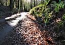
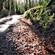
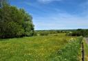
Danes Wood is access land so the interior can be explored if you wish, but the walk follows the peripheral track clockwise. Sometimes fields are visible to the left through the still-leafless trees; along other stretches the path is enclosed.
Continue, and when there are options on paths stick with the peripheral track to stay as close to the edge of the wood as possible. Just over half way round a lane appears down on the left and eventually the track reaches a gate onto the lane at Danes Cross – shown on the road sign. Danes Cottages are nearby.
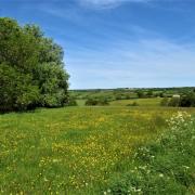
2) Pass through the gate and turn immediately right, crossing the bank and then the lane (signed for Poltimore) to reach a gate a few metres away into more woodland. This is Broadley Coppice and is also access land. In early spring these woodlands are dripping with birdsong. Even in early March swathes of snowdrops still brighten the ground – don’t pick them, they are for all to enjoy.
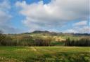
Follow the clear path as it meanders through Broadley Coppice. Sunlight slants through naked trees, a promise of warmer days to come. Towards the end of the woodland there is a good view to the left of Killerton House nestled beneath the Iron Age hill fort of Dolbury. The modern-day music of the M5 is audible.

The woodland narrows, the path emerging from the trees. Keep ahead on this permissive path, going through two gates in quick succession and following the narrow way for another 150m until you reach a stile on the left with a yellow public footpath arrow. If you reach the footbridge over the motorway you have gone too far.
3) Go left over the stile, following the arrow’s direction obliquely left across the field. The footpath leads to the far left corner of the field in a line aiming to the right of Killerton House, but electric fencing may bar the way. If this is the case, veer left to join the concrete track running through the field and turn right along it – the footpath joins this track further along.
Follow the track through Francis Court Farm, passing buildings on your right and staying with the track to reach the lane. Turn right and follow the lane for 250m.
4) You reach the stone-pillared entrance drive of Killerton near which there is a stone trough commemorating young Ellen Acland. A public footpath fingerpost directs left. Take this, walking through parkland with the drive to the right.

The substantial building on the right is Killerton’s old stable courtyard, now housing the reception area, gift shop and café. Pop in for refreshment – the area is accessible through gates from the footpath.
Continue through the parkland, passing the front of the mansion and following the line of the stone wall.
Beyond the wall the formal gardens and parkland are separated by a ha-ha – a walled ditch that acts as a barrier without interrupting the view.
The path reaches a wooden kissing gate onto a crossing track with a three-way fingerpost (4a). If you are walking the shorter option turn left here and rejoin us at point 7 below. Those doing the full walk should turn right, following the finger towards Bluebell Gate.

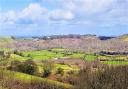
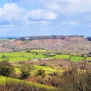
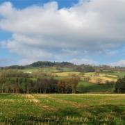
As you climb glance left for expansive valley views. There also lies the mound on which Killerton’s folly once stood. To the right are glimpses into the gardens.
5) The footpath climbs to a large wooden installation near a well-placed bench. Pause here and enjoy ‘framing the view’ – an innovative idea that makes details of the landscape stand out more.
Beyond the frame is another three-way fingerpost. Follow the direction left towards Columbjohn Wood, heading downhill to a wooden gate with yellow footpath arrow leading into woodland.
Beyond the gate three paths go left: one high, one low and one in the middle. Take the middle one with the yellow arrow and a green NT arrow, initially heading uphill before levelling out.

You may hear trains in the valley on the right rushing to and from London.
Keep ahead through the wood and soon the track leads past the site of a place that never was. The ‘lost’ Killerton house was started in the 1770s but abandoned after two years. Its whereabouts remained a mystery until being discovered accidentally by a LIDAR (Laser Imaging Detection and Ranging) survey.
During 2017 investigation of the site took place. It is thought that material from this building was re-used in the construction of the stables.
The path drops down through an area fragrant in spring with wild garlic, and reaches a gate out of the wood by a three-way fingerpost. Follow the finger towards Columbjohn Chapel and Bridge, bearing right to join a track from which the Culm Valley can be glimpsed to the right beyond trees.

6) In just over 200m the track reaches a two-way fingerpost. Take the narrow path going right – a there-and-back stretch – to pass a mysterious ivy-clad cottage followed by the bijou Columbjohn Chapel.
From the chapel there is a good view up to the folly mound. You can stroll along the broad path away from the chapel towards a grand stone gateway – the former entrance to the Aclands’ Elizabethan mansion that once stood in the field to the left as you approach the gateway.
Once you’ve explored, re-trace your steps back past the chapel and cottage to the two-way fingerpost and from it turn right, resuming the walk along the track, one of Killerton’s permissive paths.
In just over 300m you reach a crossing track by Columbjohn Farm. Turn left, a fingerpost indicates that you are heading for the House and Gardens. The puddles along this track often join hands to form small ponds but it isn’t deep – stay in the middle.

Keep ahead, passing redbrick South Lodge. Beyond here the way passes beneath trees and a path is signed left to the folly if you wish to divert – but come back here afterwards.
7) Almost 1km from Columbjohn Farm you reach a three-way fingerpost at a crossing track. Here the shorter walk re-joins us and everyone heads along the track signed for Danes Wood, large field to your right. Danes Cottages can be seen, hunkered down beneath the woodland.
The track bends left and reaches the lane. Turn right and follow it for less than 400m to Danes Cross. Here you can either stay uphill on the lane, reaching the car park in 200m, or duck once more into Danes Wood, working your way through the trees to get back to the start point.
Ordnance Survey maps are available from all good booksellers and outdoor stores or visit our online shop www.ordnancesurvey.co.uk/al
Start point: Danes Wood. Nearby postcode: EX5 3LQ. Grid ref: SX968990
Parking: There is a National Trust car park adjacent to the lane at the south-east corner of Danes Wood
Directions to start: Danes Wood is less than a mile along the lane south from Killerton’s main entrance, five miles north of Exeter
Public transport: Buses serve nearby Broadclyst and run along the main road past Budlake, from which it is a short walk to Killerton (see travelinesw.com)
Map: OS Explorer 114 Exeter and the Exe Valley 1:25 000
Terrain: Woodland paths, field paths, parkland, farm tracks, short stretch on lane. Potentially very muddy after wet weather so expect to slither and slosh
Distance: 3 miles (4.8km) or 5¼ miles (8.4km) plus optional exploration
Dog friendliness: Good, but animals may be grazing. The café welcomes dogs
Exertion: Easy, with one steady ascent to Columbjohn Wood
Refreshments: Stables Café (EX5 3LE) in Killerton’s reception courtyard
Simone Stanbrook-Byrne and James Clancy have produced a selection of West Country guides including: Favourite Walks in Devon, Circular Walks in the South Hams, Circular Walks in East Devon, Circular Walks in Central Devon, Circular Walks in North Devon/Exmoor, A Dozen Dramatic Walks in Devon, Town Walks in Devon. culmvalleypublishing.co.uk / 01392 881513