John Lenehan follows the Ribble and passes the site of an ancient battle. Unfortunately, we came second

This walk takes you on a journey back through time. It crosses two old bridges, goes past one of the county’s fine old private houses, Great Mitton Hall, and takes in a wonderfully ancient church, probably one of our loveliest. All Hallows retains a host of original features - some going back to mediaeval times - and is said to be the first Christian church in the Ribble Valley. By happy coincidence, the walk begins and ends at a pub.
1. Leave the car park and turn right and cross Mitton Bridge over the river then uphill. Turn right at the Hill Crest Tea room and go down hill past All Hallows Church.
Note: You are now in Great Mitton after leaving Little Mitton when crossing the Ribble. All Hallows Church dates back in parts to the late 13th Century. It has a bell tower with six bells, the oldest pair being from 1567 and they are still rung. There is a sundial in the churchyard that dates from 1624.
2. At the bottom of the hill the road bends left and on the right there is a footpath sign pointing right up a muddy path. On the OS map it says this is Malkin Lane. Follow the path crossing three stiles and carry on until a stile on the left leads into an open field. Cross the stile and turn right keeping the fence to the right until you see a small pond on the left. At this point bear diagonally left towards a stile in the fence in front of you.
Cross the stile and then cross a small stream and straight on to another stile in a wire fence. Then, keeping a small copse of trees to your right, bear diagonally right to a stile in the corner of the field. Cross over this stile but do not go through the gate on the right. Pass the gate keeping to the hedgerow on the right carry on until you reach a stile to the left of a steel gate.
3. Cross the stile and turn right and over the tarmac road to a double wooden gate with a white building behind it. Once through the gate there is a stile directly to the left. Cross this and turn right. There is a notice saying: Follow the Yellow Circle. Across the field behind the building there is a stile with a big yellow circle painted on a signpost next to it. Head for the stile and cross it.

4. Bear right down some steep steps to a stile by the river bank cross this and follow the river upstream. Keep to the riverbank as you cross a meadow then reach fence at a wood. Turn left to a steel gate and go through this into the wood and then through a second gate then uphill to a stile.
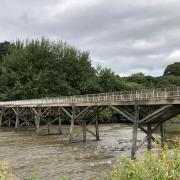
Cross this stile and then ignore the stile on the left but head steeply down hill towards the river. Cross the stile at the bottom of the hill and walk towards Edisford Bridge.
Note: Parts of the bridge date back to mediaeval times around 1339 and has nine arches although only four are above the river. Before the bridge, this was a ford and a battle was fought in 1139 between King David of Scotland and the Lancastrians. We lost.
5. Cross Edisford Bridge then turn right onto the opposite bank and follow the track downstream past the miniature railway and park and the caravan site on the left. The track eventually climbs uphill then turns sharp left then sharp right to a gate. Go through the gate into a lane and turn sharp left to a tarmac road.
6. Turn right and follow the road past the waste disposal centre and on towards a group of buildings. Pass the buildings of Fishes and Peggy Hill on the left and a row of cottages on the right and just before the gates of Shuttleworth Farm cross the stile on the right. Cross a small field and cross a stile then go behind the barn to a track that leads to a gate and stile into a field by an aqueduct.
Note: The aqueduct carries water from Haweswater in the Lake District 72 miles to Heaton Park reservoir in Manchester and my grandfather worked on the building of it.
7. Keep to the riverbank until you reach a small building used for water flow measurement and a weir. Then bear diagonally left towards a footbridge and cross this. Climb uphill to a stile then cross this and keep to the fence right to another stile. Cross this and the follow the path back to the Aspinall Arms and through a stile on to the main road and right to car park.
COMPASS POINTS
Walk: Mitton Edisford Bridge Loop
Start and Finish: The Aspinall Arms: Mitton Road Clitheroe: BB7 9PQ Tel: 01254 826555: Email aspinall.arms@brunningandprice.co.uk
An easy, circular walk to Edisford Bridge and back along the beautiful River Ribble.
Terrain: Flat walking across fields and good tracks. There are a couple of very short steep sections down to the riverbank and a little bit of road at the start and crossing Edisford Bridge.
Distance: 4.75 Miles/ 7.6 Km
Time 1.5 to 2 hours
Map: OS Explorer 41 Forest of Bowland and Ribblesdale
Facilities: Toilets and food: Aspinall Arms. Also nearby are the Hillcrest Tearooms and The Three Fishes. Public Toilets: Edisford Bridge.


