Keith Carter leads a circular walk around the charming village of St Michael’s on Wyre

I counted 189 places named after Saints in my Collins Road Atlas including six St Michael’s, an indication of the durability of the Christian tradition in our green and pleasant land. Our St Michael’s is properly called St Michael’s on Wyre, without hyphens, although nobody uses the full name.
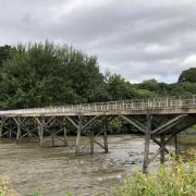
The River Wyre’s name is said to be of Celtic origin meaning winding river. St Michael’s appeared in the Domesday Book as Michelcherche, and the church is described in Pevsner as ‘a typical late Medieval North Country church better-preserved than many’. The river crossing was the reason for a settlement here. Today’s bridge replaces much older bridges, the traffic volumes infinitely greater than in the olden days.
I took the liberty of parking in the primary school car park, although if your return coincides with school coming out the 4x4s pack it out as parents come to collect their children.
Start the walk by crossing the bridge to where a footpath departs on the left with a signpost indicating the Wyre Way. This 48-mile route is not so much a Way as a series of linked field paths with insufficient way-marking. I suspect the reason for the route becoming neglected in recent years is due to The Cuts, the coffers of Wyre Borough leaving nothing left for improving signposting and maintaining stiles.
Follow the bank of the river away from the village, soon passing a tidy little fishing lake that looks as though it belongs in Toytown. The path meets the road at a stile and we turn right to walk along it for a couple of hundred yards to where an opening leads to a caravan site at Turnover Hall Farm where the farmer has made a business from storing caravans. There are hundreds of them, lined up in rows, mutely waiting for the day when they will be needed again. Unfortunately the right of way through the farm buildings is unclear and you can find yourself lost in a maze of caravans.
Entering the farm yard turn right then left after a large barn and walk along the ranks of caravans to the next junction where you turn left then take the next right. On confronting a duck pond keep to the right of it and walk along a field margin, the hedge on your left. When I researched this walk potatoes were growing in the field and a roe deer suddenly broke cover and pranced across the rows, seemingly avoiding trampling on the crop.
We come to a fishing lake where the brilliant blue flash of a kingfisher caught the eye. Follow round to the right and in the top corner look for a concealed stile in the right hand hedge. Look ahead and you should see a tall silo prominent across two fields. Make for it, encountering a locked gate at one point with a collapsed stile beside it, another example of the absence of maintenance on this right of way.
On reaching the silo, keep to the left of it and cross the top of a field past a huge silage tank to exit the field by a stile. From here the footpath heads across a field planted with a maize crop with plastic covering the roots, a clear way left for walkers. After two smaller fields we emerge on a track with a newish bungalow over to the left with barking dogs in a pen.
Keep a barn on your right and follow a tarmac lane as far as the brickwork gateway to Crabtree Farm. Take a stile to the left and enter the first of a series of fields keeping the hedge on your right and crossing a number of stiles until you emerge on a lane. Here cross over to a stile nearly opposite taking you into a paddock where the owner has mown a path for walkers. There are several signs to keep you on the right track. We join the top of a lane beside Bowland House and walk down to where it meets Lancaster Road. Turn left and we soon part company with the Wyre Way which goes down Sandy Lane to the right as we stay on the road to a T-junction. Turn right then next left and cross the toll bridge to arrive at the Cartford Inn.
From the pub our walk begins the return leg by following the right hand bank of the river where an embankment has been built up as part of the measures to control flooding. The river is tidal here and the incoming tide was moving at quite a pace, faster than you could walk.
There are occasional stiles to cross but stay on the embankment and take no notice of an insignificant footpath that leads to Great Eccleston. We come eventually to the road, the A586, which has to be crossed to a stile in the opposite hedge keeping ahead along a feeder dike as far as a bridge across it on the left.
Head for the prominent white-painted gable of a house across two fields and on reaching it emerge onto a lane. Take the stile opposite and keep right through a gate into a meadow which the right of way crosses keeping parallel to a wood over to the left. After a footbridge in the hedge, cross a second meadow to a lane then a further field to the corner of Dolly’s Wood where a stile in a gap in the hedge brings us into a neglected field with a large spreading beech tree under whose branches we pass.
Walk beside a left hand boundary on a rough field edge and join the access track to a new property, Ashley Hall.
Turn left and follow the lane to where it meets the main road in St Michael’s. Turn right then right again and the primary school is on the right.
Compass points
Area of walk: St Michael’s and the River Wyre
Distance: Seven miles
Time to allow: Four hours
Map: OS Explorer 296 Lancaster Morecambe and Fleetwood
Refreshments: The Cartford Inn
Not suitable for wheelchair or pushchair users.


