A summer’s walk on Dartmoor with woodlands, wide views – and absolutely perfect tea gardens nearby which SIMONE STANBROOK-BYRNE enjoyed discovering

Years ago I met someone who had written a Mills & Boon novel and the only thing that had been edited out, as being far too improbable, was the only thing in it that was real: the setting of Lustleigh.
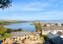
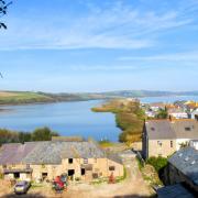
With its idyllic Primrose Tea Rooms and Gardens, excellent pub and delightful thatched ambience this romantically-named village is a lovely Dartmoor destination. Add in a walk on the surrounding moors when the weather is clear and you have a great summer's day out.
The walk starts to the west of Lustleigh, away from the village centre - so make sure you leave time to savour the treats in the heart of Lustleigh too.

Route:
1) The walk starts along the gently rising bridleway that leaves the lane between the houses of Grove and Loganstones. A fingerpost indicates that you're heading for various places including the Cleave and Hunter's Tor in 1¼ miles.
In 100m the path passes through a gate and arrives at a fingerpost. Take the onward option to Hunters Tor and 'ancient camp' (you will be arriving back here via the left-hand path at the end of the walk).

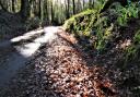
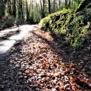
The path winds upwards through verdant, atmospheric woodland scattered with muscular boulders and full of moss-covered gnarly bits and festooned trees. If Lustleigh's church bell ringers are active on the day you walk the fruits of their labours will distract you from the long ascent.
Occasional blue bridleway arrows reassure that you're on the right path and an attractive dry stone wall comes in to meet you from the right.
Stay on the rough, but clear and winding path, still climbing, with the dry stone wall over to your right; sometimes you are walking right beside it. It's quite a feat of construction.

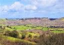
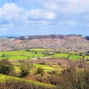
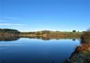
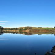
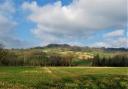
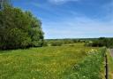
2) The path levels out for a while, along the rim at the top of Lustleigh Cleave, at which point views to the left open up looking across the moor to Hound Tor.
Continue onwards, still following the line of the wall to the right, the path flanked by high bracken in summer. The tree cover reduces and the panorama to the left is expansive; look out for the view towards a fabulous grass-roofed private house far away across the valley.
Stay with the clear path, occasionally under trees again and still climbing, though not as steep as at the start. When not under trees the views are spectacular; the eye-catchingly light-coloured tower of Manaton Church is very noticeable

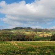
3) Eventually the wall wanders away to the right. Keep ahead. As you continue the nub of Haytor comes into view in the far distance over your left shoulder.
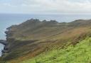
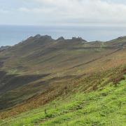
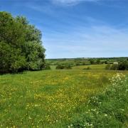
At grid ref SX763821 look for the scatter of boulders to the right of the now-level path. You are approaching the remains of an ancient Iron Age settlement (at grid ref SX761824), evidence that people have been here for centuries. It is now a place of vibrantly-golden gorse, grass and Dartmoor hill ponies, in this high and open area of Hunter's Tor.
There are various paths through the gorse along this stretch; keep generally ahead. The dry stone wall reappears and, 1¼ miles from the start, the path meets the wall at a gate where the granite outcrop at the edge of Hunter's Tor is to the left - a great viewpoint.

4) Go through the gate - a fingerpost denotes 'path' - and turn sharp right as directed, following the well-trodden and descending path; a wall is to your right, though may be concealed by bracken.
Swing sharp left in 250m by another two-way, lichen-upholstered fingerpost and keep going downhill. In less than 200m the path passes through a gate with a faded bridleway arrow, bear right after this.
Soon the church tower in North Bovey comes into view ahead and the path passes the buildings of Peck Farm; we met some very attractive and peaceable cattle here - but keep the dog on a lead please. Go through a gate between two stone barns then keep ahead away from the farm along their drive.

5) In about 150m the drive turns right near a three-way fingerpost but here the walk goes left, signed, rather indistinctly, towards Foxworthy Bridge.
This is a clear bridleway beneath trees, pleasing downhill walking that soon passes beneath an architecturally-leaning tree trunk (if it hasn't been removed). Go through a gate and continue, enjoying occasional gateway views to the right.
6) In just under ½ mile you arrive at Foxworthy. Pass through a blue arrowed gate and walk ahead along the cobbled track, passing in front of an attractive house. As you reach their steps on the left turn right, downhill on the drive towards the audible River Bovey.

Within 50m, at a three-way fingerpost, go left towards Hammerslake and Horsham, following a track with the river over to the right.
Stay on the obvious bridleway, passing Foxworthy Mill about 200m from the fingerpost, then go through a blue-arrowed gate and continue downhill beneath trees, river still to your right, though not visible from the path.
7) In about 160m you reach a three-way fingerpost near a wooden construction containing fire beaters, just in case! Keep straight ahead towards Hammerslake and Lustleigh.

Look out for dor beetles through this woodland; don't step on them, they have an important job to do. We found one who had tripped over and was on his back, waving his legs about and showing his iridescent blue underbelly. We helped sort him out and he trundled off quite happily.
Continue on this stretch of gently undulating, bendy and pleasing woodland walking through the valley of Lustleigh Cleave. Stay on the main path with occasional reassuring markers.
A mile from Foxworthy Mill you reach another three-way fingerpost. Follow the left-hand finger towards Hammerslake and County Road. The path swings left and forks just over 200m from the fingerpost - either way is fine as both lead down to a fingerpost that you've seen before, in just over 100m.
Go through the wooden gate by the post and retrace your steps down to the lane from which you started.
Ordnance Survey maps are available from all good booksellers and outdoor stores or visit our online shop www.ordnancesurvey.co.uk/al
Look out for
- Expansive views
- Site of Iron Age hillfort
- Dartmoor hill ponies
- Dor beetles in the woods
Directions to start: Lustleigh is in the north-east of Dartmoor, four miles from Bovey Tracey, accessed off the A38
Parking and start point: The start point is ¾ mile from the village centre. On-road pull-ins near start of walk. Grid ref: SX775816. Postcode: TQ13 9SQ
Public transport: Buses to the village are infrequent, see travelinesw.com
Map: OS Explorer OL28, Dartmoor 1:25 000
Terrain: Tracks, moor and woodland paths, sometimes rough underfoot. The route is usually clear to follow but if you have a GPS it may be handy
Distance: 4 miles (6.5km)
Dog friendliness: Good
Exertion: Moderate to strenuous; there is a long ascent during the first section
Toilets: None en route
Refreshments: Primrose Tea Rooms and Gardens, Lustleigh, TQ13 9TJ (01647 277365); The Cleave, Lustleigh, TQ13 9TJ (01647 277223)
From Circular Walks in the South Hams, one of a selection of West Country walking guides from Simone Stanbrook-Byrne and James Clancy. Others include: Circular Walks in Central Devon, Circular Walks in East Devon, Circular Walks in North Devon/Exmoor, A Dozen Dramatic Walks in Devon, Favourite Walks in Devon, Town Walks in Devon. culmvalleypublishing.co.uk / 01392 881513