Simone Stanbrook-Byrne enjoys a view-rich and varied summer route along the western edge of Dartmoor

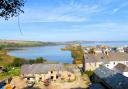
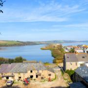
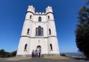
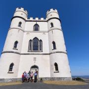
Standing tall at the western edge of Dartmoor, the once-volcanic Brentor is an iconic sight. The church of St Michael de Rupe, the smallest and highest complete parish church in England, graces the top. Lit by gaslight, it is a place of pilgrimage for those of any religious or secular persuasion, the lung-stretching ascent to reach the top enticing walkers from all directions. It commands a panorama that is worth every scrap of effort to get there – and there are plenty of sky-high resting spots, whether on a well-placed bench or in a pew.
To visit Brentor on this walk requires a there-and-back stretch that adds almost two miles to the walk. For those who don’t wish to do this there is a car park that serves the hill, shown at grid ref: SX468805 on the map, although there’s no shirking - you still have to walk up to the top!
Pick a clear day, gather your boots, binoculars and a sumptuous picnic and enjoy a fabulous summer walk on the moor.
Route
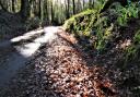
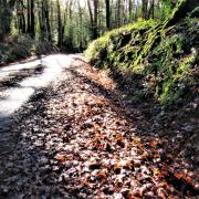
Start the walk from the war memorial, along the road signed for Tavistock. Within 100m go left down Darke Lane. The surfaced road soon runs out as a fingerpost points along an unsurfaced and potentially muddy track towards South Brentor. Follow this. About 100m beyond the houses the track reaches a group of gates; don’t go through any but turn left on the continuing track between hedges, enjoying gateway views towards the moor.
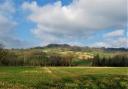
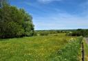
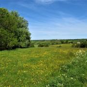
In 100m a two-way fingerpost points through a gate, still towards South Brentor. Enter the field and keep ahead alongside the right-hand boundary to the gate on the opposite side. The rising moorland to the left is evocatively-named Gibbet Hill and there are good views behind back to North Brentor.
At the end of the first field pass through the gateway then bear slightly left across the next field towards a gap, beside which is a venerable and attractive kissing gate that wasn’t designed to accommodate large rucksacks. Beyond it, walk across the field in the same line as before, passing a telegraph pole on the left, to reach another old and narrow kissing gate on the far side. Find someone old and narrow to kiss then glance at the fingerpost.

Follow the line of the onward finger that directs slightly right, uphill to the far corner. Here, pause beside the gate and stile to enjoy the view behind and also glance right (west), through the hedge, for a glimpse of Brentor’s church, peeping over the hillside.
Negotiate the tall stile or go through the gate. A fingerpost shows ‘path’; follow its direction ahead, bearing slightly right to a small, yellow-arrowed post about 30m away. From this post follow the narrow path up onto the hummock, soon passing a pond on the right.
The path emerges into a field where another arrowed post directs to a gate about 50m away. From this an arrow directs straight ahead along the track. The footpath follows this track as it winds about to reach a crossing track in 300m from which there is a good view to Brentor.
From here there are choices. Those planning the shorter option turn left along the track and pick up the directions from Point 5.
Those partaking of the there-and-back stretch of almost two miles to the church (which I would recommend), turn right along the track, soon passing the buildings of South Brentor Farm. The track reaches a lane at a Y-junction; keep ahead, along the left-hand fork. At a cluster of houses in 200m continue ahead. This quiet lane passes various cottages that enjoy glorious views; stay with it.
Almost 150m after Brennen Cottage the lane bends sharp left. Here, leave the lane through the gate on the right, beyond which are two separate fingerposts. Follow the direction of the one on the right that shows ‘Permissive path to Brentor Church’. Follow the straight line of the right-hand hedge up to a gateway with a fingerpost pointing back to ‘Road at Holyeat’ (a nearby farm).
Take note of this spot as you need to descend back down to this point after the climb. The steep hill is directly ahead and is access land. Wind your way up; various paths lead to the top so take note of your route as you go round and ever upwards until the summit is reached. Phew! From this direction the church is approached from its south side (away from its porch).
Spend a while at the top, it’s always possible to find shelter from the wind, either inside or out, and it is a truly awesome location.
When you’ve had enough retrace your steps down, the long line of the hedge that you followed up to the fingerpost near the base of the hill is a useful visual aid to direction, with a black-roofed barn visible across the lane. Once at the fingerpost follow the hedge back down to the gate onto the lane and turn left to retrace your steps back to the track beyond South Brentor Farm.
The track passes the footpath from which you emerged earlier and picks up the faint-hearted who elected the short option.
Keep ahead on the track as it bends about between hedges, heading towards the open moor. Within 500m it crosses the two sections of Wortha Mill Bridge, spanning the River Burn and the adjacent disused railway line between Lydford and Plymouth, which closed in 1968.
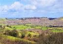
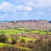
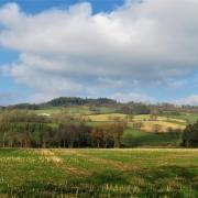
Continue with the track as it passes Wortha Mill, climbing beyond it and bending left near a large white house called Blacknor Park. Continue with the track as it passes round the rear of Blacknor Park and becomes better surfaced. Glance around as the views open up: to Brentor, to the church at North Brentor and increasingly across expansive moorland.
You join a road near a salt-grit box. Keep straight ahead uphill, walking on the moorland verge to the side of the road. The valley of the River Burn is down to the right, bearing the delightful name of Smallacombe Bottom. This is easy, enjoyable walking, heading for the outskirts of Mary Tavy with the high-rising moor beyond.
The road widens then narrows again, passing a handy bench on the right. After almost half a mile along the road verge, 50m before the cattle grid sign and before the first cluster of houses, look for the post on the left just beside the road that bears a blue bridleway arrow on its far side (6a). Take this bridleway, going obliquely left back on yourself, heading up onto the moorland with the road down to your left, the outskirts of Mary Tavy behind and a view towards Brentor ahead and left.
The bridleway passes a diminutive cairn on the right near a small leaning stone with, after wet weather, its own tiny pond. Keep ahead on the rising path and as it levels out the church tower in North Brentor is straight ahead. Brentor is now up to the left. The track becomes stony in places and sometimes damp with springs. Stay with it until it meets the road at Wortha Farm.
Turn right along the road, walking on the left-hand verge beside splendid beech trees. Ignore a turning right and cross the cattle grid ahead, joining Sustrans Cycle Route 27 (summer route!).
The road leads past the former station on the edge of North Brentor, now a beautifully-kept private house that takes great pride in its railway heritage. The road bends left and in just over quarter of a mile you pass Christ Church (a chapel-of-ease to St Michael’s on Brentor) and reach the war memorial in North Brentor.
Next month we head for Stoodleigh
Start point and parking: On-road in North Brentor, near war memorial/church – please respect residents’ access. Grid ref: SX481814. Nearby postcode: PL19 0LR
Directions to start: North Brentor is to the west of Dartmoor, just over five miles north of Tavistock
Public transport: Buses do serve the village, see travelinesw.com
Map: OS Explorer 112, Launceston & Holsworthy 1:25 000
Terrain: Field paths, moorland tracks, quiet lanes. Occasional damp areas. A compass may be useful
Distance: 3¼ miles (5.25km) for short option/5¼ miles (8.5km) for full walk
Dog friendliness: Good. Livestock may be grazing. The Mary Tavy Inn (off-route) allows dogs in bar
Exertion: Ascent up Brentor very strenuous, otherwise easy/moderate
Toilets: None en route
Refreshments: Take a picnic as the walk doesn’t pass any inns, although you could divert and extend the walk into Mary Tavy for refreshment: the Mary Tavy Inn, 01822 810326
Look out for:
Historic churches
Evidence of former railway
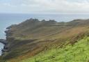
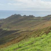
Mighty views across Devon and Cornwall