Simone Stanbrook-Byrne enjoys a North Devon coast walk of majestic scenery, nuggets of history and excellent refuelling stops

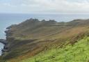
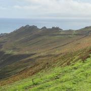
The scenery of this region is majestic, dramatic and utterly beautiful. On a blue sky summer’s day when the sea is turquoise it just doesn’t get any better. But behind the grandeur lies some tragic history.
Extremes of weather are frequent features of 21st century news, but the picturesque village of Lynmouth was devastated by one such phenomenon decades ago. In August 1952, after 23cm of rain in 24 hours, the already swollen rivers were unable to cope with the deluge.
Lynmouth and its environs bore the full force of millions of tonnes of water and accompanying debris, resulting in the collapse of 39 buildings and the deaths of 34 people. Much speculation remains as to the cause of such excessive rainfall. Nowadays a tranquil garden marks the site of destroyed homes but it’s sobering to consider the forces of nature which have shaped the landscape over centuries.
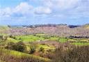
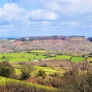
This glorious walk explores some of the very contrasting terrain of the Exmoor coast, starting in the deeply wooded gorge of the East Lyn River and finishing along open and airy paths high above the sea. Be prepared for a bit of a puff on the uphill section and you will be well-rewarded for the effort.

Route:
1 At the bottom of Countisbury Hill in Lynmouth the main road crosses the river on a stone bridge. Descend the steps by the bridge, adjacent to the phone box, and follow the path with the East Lyn River on your left, walking away from the coast, car park to your right. Pass a footbridge in 200m without crossing and soon you reach Middleham Memorial Gardens, site of cottages destroyed in the 1952 flood.
At the second bridge (Woodside Bridge) cross the river and now follow the frequent signs for Watersmeet, always taking the riverside option when there are choices and ignoring any signs for Countisbury for the time being – that comes later.
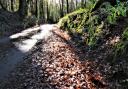
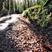
This river is beautiful in all seasons and is spectacular after heavy rain. It’s an excellent area to spot Dippers, the bird that symbolises the Devon Wildlife Trust, as well as the yellow flash of Grey Wagtails and their dapper little Pied relatives. The route crosses the river again at Blackpool Bridge after which you keep the water to your left until Watersmeet. As you continue keep an eye open for the site of the former Lynrock Mineral Water Factory, whose buildings were destroyed in 1952 but where you can still see an old fireplace and one of the company’s ginger beer bottles set into the right-hand wall of the gorge.
The path is up and down at times as it follows the line of the river, passing the idyllically situated Myrtleberry, former home of Lynrock’s owners. Follow the river until it brings you to Watersmeet House, 1¾ miles from Lynmouth. Here, two successive footbridges cross Hoar Oak Water followed by the East Lyn River – the two waters that meet here.
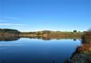
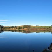
Set at the confluence of the rivers, Watersmeet House was built as a 19th century fishing lodge and ‘romantic retreat’ by Rev Halliday, lord of the nearby Manor of Glenthorne. He was a great admirer of the poets Coleridge, Wordsworth and Shelley, who had likened the local scenery to that of the Alps. This may have given rise to the area’s being dubbed ‘Little Switzerland’. In 1901 Watersmeet became a refreshment stop serving teas, a tradition continuing to this day. Some of the garden’s more majestic trees have been lost in recent years but it’s an excellent spot for birdlife – I once shared a table with a Hawfinch.

2 After a sustaining pause continue beyond Watersmeet House, passing the buildings and toilets on your left with the river to your right. You quickly reach a fingerpost denoting the footpath to Rockford. This is part of the Coleridge Way with its quill symbol. Take this path, climbing steeply to a three-way fingerpost where a left option points you towards Countisbury. Go left here, winding up through the woodland on the well-trodden path – don’t be tempted to veer off on any downhill options (sorry!). If the trees aren’t too leafy Watersmeet and its gardens can be seen below as you climb. The path eventually begins to level out and the trees become sparser. Note the fluffy fruticose lichen on the branches, a sign of clean air.
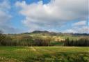
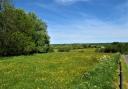
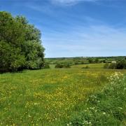
3 The path forks, both options reconvening in a few metres at a four-way fingerpost. Here you have two choices for Countisbury – take the yellow-marked one straight on (which is through a gate just to the right of this post). The well-trodden path goes up the field beyond the gate, passing thickets of vibrantly-yellow gorse; on a warm day its coconut fragrance perfumes the air and reminds me that gorse flowers make excellent homemade wine. The path passes a lone post with a confirmatory arrow carved into it; enjoy the superb views behind as you climb.This line leads across the delightfully-named area of Trilly Ridge, reaching the corner of the field and a series of gates. Keep straight on for Countisbury along a broad track between stone walls. Countisbury Church is ahead and slightly closer to hand is The Blue Ball, a favourite stop for boots, dogs and hearty fare.
4 When you reach the road turn left along it (watch out for traffic). In 85m go right along the lane towards the church, unless you are diverting first for succour at the inn.

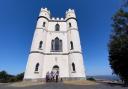
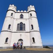
The church, with its Saxon origins, is worth a visit. Notice the framed poster at the back advertising Countisbury’s Coronation Festivities in June 1911, when King George V was crowned. From the church porch follow the path round to the back and leave the churchyard via the gate leading out onto the headland.
5 From here, if you wish to divert to see the National Trust’s lighthouse on Foreland Point, turn right to join the coast path round the headland – but you will need to retrace to this churchyard gate.
Once through the gate turn left beside the boundary. The sea comes expansively into view to the right as you join the coast path. On a clear day Wales is visible over your right shoulder.
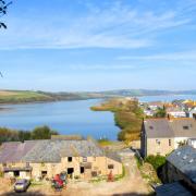
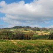
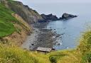
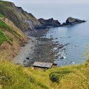
About 300m from the church a three-way fingerpost directs right, steeply downhill on the acorn way-marked coast path. Stay with the coast path now, returning to Lynmouth, about 1¾ miles away. An awesome stretch of walking. Along this section we spotted deer, warily watching us from the steep slopes below. The views along the coast are tremendous in both directions, ahead towards Lynmouth, behind to Sillery Sands.
About 800m from the fingerpost the path passes the remnants of a disused quarry. Keep following the clearly-signed coast path until it brings you out to the road. Turn right along the road, walking through a lay-by area at the end of which a narrow earth path leads off beside the road. Follow this to keep out of the traffic to a three-way fingerpost in about 250m

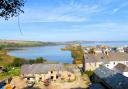
6 From here follow the coast path away from the road and into the trees. This winds down and is clearly signed all the way, eventually landing you on a tarmac lane with a stone wall in front. Turn right then swiftly left, circumnavigating the buildings and gardens of The Manor House. Follow the broad, tarmac path, the harbour to your right and Lynmouth’s buildings ahead. The path winds back towards the river. Turn left beside it to return to the road bridge from which you started. Lynmouth’s many eateries await.
Compass points
Start point: Road bridge at bottom of Countisbury Hill in Lynmouth. Grid ref: SS723494. Nearby postcode: EX35 6EX
Directions to start: Lynmouth is on Devon’s north coast, on the A39
Parking: Various pay and display options
Public transport: Lynmouth is served by buses from surrounding areas, see travelinesw.com
Map: OS Outdoor Leisure 9, Exmoor 1:25 000
Terrain: Riverside, woodland, field and coastal paths
Distance: 5 miles/8km
Dog friendliness: Coast path edgy at times. Brief stretch of path beside road. Animals grazing
Exertion: Moderate to strenuous; one long ascent. Strategically-placed benches throughout
Toilets: In Lynmouth and at Watersmeet (seasonal)
Refreshments: Many options in Lynmouth plus The Blue Ball Inn, Countisbury (01598 741263) and Watersmeet Tea Gardens (National Trust, seasonal, 01598 753348)