You will find yourself following in the footsteps of Samuel Taylor Coleridge as you take this lovely walk containing many contrasts, reveals Simone Stanbrook-Bryne

Samuel Taylor Coleridge, romantic poet and author of Rime of the Ancient Mariner and Khubla Khan, was born in 1772 at Ottery St Mary, where his father was vicar and headmaster. Over 200 years later he is commemorated in this area by the Coleridge Link Path, allowing walkers to explore the glorious countryside between Ottery, Tipton St John and Harpford.

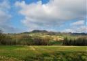
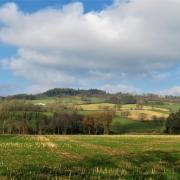
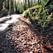
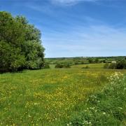
This walk of lovely contrasts starts at Tipton and follows some of Coleridge’s path, enjoying tranquil river valleys, green lanes and fabulous views. You will come across attractive rounded stones, or popples, which have their origin in the East Devon pebblebeds, ancient geological layers created during the Triassic era when the lie of the land and the climate were very different.
The popples were formed when this area was a desert region near the equator where a mighty river flowed, tumbling the stones into their rounded shape. The river dried up, subsequent wind erosion polished the popples and ‘continental drift’ brought them here.
1.
Walk through the village passing the Golden Lion on your right and within 100m you find a footpath signed on the left. Take this narrow way to a stile and continue beyond, watching out for the mud! Cross a second stile and keep going. The path opens up into a field, walk ahead as directed by a yellow-arrowed post.
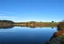
To your left as you enter the field you’ll see the arches of an old railway bridge over the River Otter; the railway closed in 1967. The river is some way to your left although from time to time you have a small stream immediately on the left. At the end of the field pass through a metal gate and keep going in the same direction, passing more occasional gates until the path reaches the buildings of an old mill, just over 600m from the village.
2.
Near the mill you find a footbridge spanning the river. Cross here, listening out for the chug of a nearby Archimedes Screw, and as you descend off the bridge go fully left again, so that the river is still to your left. Within 30m you pass through the remains of an old field boundary, after which walk through the field towards the end of the railway bridge. When you reach the bridge go straight past it, crossing the line of the former railway and continuing in the same direction, river to your left. You’re heading towards houses on the outskirts of Tipton St John.
Follow the river to a gate out of the field – be careful as there is potentially more mud here. Beyond this bear right under the trees on a clear path. This leads to the lane into the village. Turn left along it, ignoring the first right (Metcombe Vale) and keeping ahead to reach the elevated church of St John the Evangelist. This is worth a visit for its lovely windows and attractive reredos screen. Return to the road through the gate at the lower, far end of the churchyard and turn immediately right on the lane for Venn Ottery and Newton Poppleford.
3.
This quiet lane bends about and climbs. Follow it past the village sign for Venn Ottery (from ‘Fenotri’, meaning marshy place by the River Otter) and as the lane bends sharp left, just over 400m from the church, keep ahead on a drive that’s ‘unsuitable for motors’, ignoring the bridleway to the right. The drive leads past houses and becomes a track, climbing gently. In 400m ignore another bridleway on the right and take the left turn about 60m further along. You’re quite high now and can enjoy good views from gateways. The track descends, ignore a right hand track and keep straight on.
You emerge on the road at Venn Ottery. Keep straight ahead along the lane opposite. Soon you pass Barton Mews on the right and if you wish to visit the bijou church of St Gregory with its 12thC tower, go down Barton Mews to reach it. Otherwise keep ahead along the lane and in just over 100m you find a right turn signed as ‘unmetalled’, although it is surfaced at this point. Take this, passing a few houses, and keep ahead for just over 200m until you reach a solitary house called Wayside on the left. Turn left here.
4.
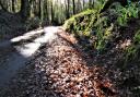
Beyond Wayside the path climbs between hedges. Keep on, ignoring any side turnings for almost 600m until you reach the lane opposite a house called Harleyford. Turn right along the lane and in 150m go left by some thatched cottages then left again in 40m; there are plenty of popples about here.
Within 100m you find a footpath over a stile on the right. Take this and walk ahead with the boundary to your right. Within 50m you reach a yellow-arrowed post, turn left and in about 30m the path goes sharp right again, winding through this orderly nursery. You soon reach another arrowed post, the arrow pointing obliquely left although the well-trodden path goes straight ahead. Follow the path and in less than 100m you find a stile onto the lane. Turn left; this is the East Devon Way.
5.
Follow the lane – at the right time of year there are pretty cottage gardens along here. You reach a T-junction with the entrance to the nursery on your left. Go left on the lane for a brief 15m then turn right through a gate with a footpath sign and a nice, pink East Devon Way arrow pointing you on your way. Walk ahead between hedges and as the field opens up bear right to follow its right-hand boundary, enjoying views to your left as you climb.
You reach a stile, keep straight ahead beyond it as the arrow shows, following the line of tall trees with orchards on either side – this bit of the walk is a real treat! You reach a footpath T-junction with a view ahead towards Harpford. Go left for 30m then turn right down steps – this is still the East Devon Way. Follow the path gently downhill to a kissing gate. Descend the steps beyond here (hang onto the hand rail) and at the bottom go right. Don’t trip over the tree roots!
6.
You soon reach more steps; descend and go left to cross a footbridge and emerge into a field. Bear slightly right across the field, towards the right of Harpford Church tower, to where another footbridge leads out of the field. It was on this stretch that we watched a hobby chasing martins. Cross the footbridge and follow the short path to another kissing gate – once more crossing the old railway line. After the kissing gate walk through the field, the fence to your left.
At the end of the field you reach Harpford Bridge. If you wish to visit the village cross the bridge, but otherwise go left, the River Otter on your right. A kissing gate leads into the next huge field. Follow the well-trodden path, the field boundary, with the river beyond, to your right. Occasionally the river meanders off but keep going following the field path until you reach the road. Cross over, watching out for traffic, and turn right along the pavement. The road leads back into the centre of Tipton St John, passing the Golden Jubilee Clock on the way – a decorative finish.
Look out for:
-Ancient ‘popples’ from the East Devon pebblebeds
-Tiny St Gregory’s Church in Venn Ottery
-Interesting birds: we saw a hobby and a little grebe - but no albatross!
-Golden Jubilee Clock
This article was first published in the March issue of Devon Life. To get the magazine delivered every month to your home, subscribe at www.subscriptionsave.co.uk/dev or call 08448484217