

Suffolk is the perfect county to plan a leisurely walk that all the family can enjoy, whether you're spending time beside the coast or in the gently, rolling countryside. These easy going walks provides opportunities to enjoy the great outdoors
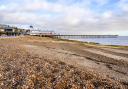
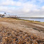
Southwold - Distance: 4 miles/6.4km
Start in front of Southwold Pier facing inland. Turn left and follow the path beside the railings, onto the low cliffs to South Green (signed). Turn right. Walk across the grass until you come to a large green. Cross the road, head towards the post box, continue into a short dead-end lane. At the end, take the path between two flint walls. As the path turns left, continue along on the footpath.

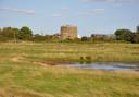
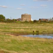
Turn right at the road. Follow the road past a car park entrance, turn left at the junction along Godyll Road. Follow the road with Southwold Common on the left. A big green opens up on the right, continue along the road as it bends to the right. At the T junction, cross the road and turn left towards the two water towers, using the mown path next to the road.
Take the grass path leading diagonally across the green, heading just to the right of the towers. Keep on this path across the golf course until you reach a junction with a track. Turn left, towards Walberswick. This is the track bed of the Halesworth to Southwold Railway, which closed in 1929. Just before the river bridge, turn left.
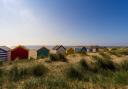
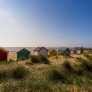
Follow the footpath alongside the river to join the unmade road through Southwold Harbour. When the road turns sharply left, leave it and cross the car park. Walk over the dunes onto the beach or follow the wide grassy area behind the dunes. Reaching the first beach huts, look for the Gunhill Beach Café.
Take the path beside the café that turns right and leads up Gunhill Cliff. Walk through the gardens beside the railings and drop down to the promenade which will take you back to the pier.
Snape & Sailors’ Path - Distance: 3.75 miles/6 km
Start at The Crown pub. Turn right along the road towards Aldeburgh, then first right, past the Golden Key pub. Near the top of the hill, turn left on to a bridleway. Stay on this track, Guilding’s Lane, as it bends left (sports field hedge and play area on right) then past housing (left), open fields (right) to an uncultivated grassy area, with views of Snape church tower.

At the T-junction with the road, turn right. Where road bends right, take the third track on left signed Public Footpath, Aldeburgh 4 miles, and New England Farm. This is the Sailors’ Path. Continue straight past a pair of red brick cottages, Sailors Path Cottages. Go through the gate (right) into Open Access land.
Follow the path through woodland to a clearing. Make your way to a wire fence boundary (on right), and follow this downhill, to a kissing gate. Cross the road, go through the kissing gate opposite. Continue to follow the fence line through this open access land, Snape Warren.
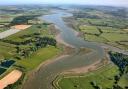
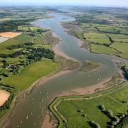
At the foot of the slope is another kissing gate. Just before it, bear left uphill. Head straight on through woodland then heath. Eventually you will see the square church tower of St Botolph’s Church at Iken in the distance. The length of the Alde estuary is visible from here.
Go down the slope towards the river, and through a kissing gate. Turn right, Snape Maltings is in the distance. Reaching the Snape Explorer interpretation board turn left to follow the path along the river wall. At the road turn right, back to the Crown Inn.
READ MORE: Explore Suffolk's beautiful bluebell woods
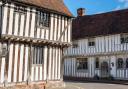
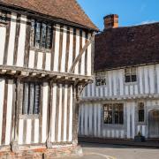
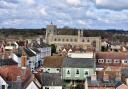
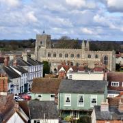
Long Melford - Distance: 4.5 miles/ 7.5 km
Park opposite Melford Hall. Head out of town along Bull Lane to a bridleway. Reaching King’s Lane, join the grassy Melford Walk, once a railway line that carried passengers between Sudbury and Bury St Edmunds. At the junction with Hall Street turn right and head through the centre of town, then up to Holy Trinity Church, following a section of the Stour Valley Path, through open fields to Kentwell Hall. Return passing the impressive turrets of Melford Hall.

Along Hall Street you will see buildings that mostly date from the 15th and 16th centuries when the cloth industry was at its height. They include The Bull Inn on the east side and Brook House, opposite, once the White Hart Inn. The Cocoa-nut House (west side) is believed to date from the late 14th century. The building was named the Cocoa-nut House in the 19th century when it was part of an industrial site where coconut matting was woven.
Melford Place, opposite Chapel Green was the home of the Martyn family who built the Martyn Chapel in the church. Holy Trinity Church (top of Melford Green) was rebuilt in the second half of the 15th century and was funded mainly by bequests from local people who had become wealthy from the cloth industry, and from the Clopton family at Kentwell Hall.
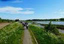
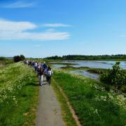
Waveney Carlton Marshes - Distance: 3 miles/4.8km
An easy walk for all the family, with lots to see. Carlton Marshes lies at the southern tip of the Norfolk and Suffolk Broads and comprises over 100 acres of grazing marsh, fens and peat pools. The walk starts from the visitor centre, goes across the marshes to the River Waveney and returns along the Angles Way.
The marsh is managed by Suffolk Wildlife Trust who organise a series of events during the year (suffolkwildlifetrust.org). With the visitor centre at your back, head towards the marsh. Immediately after passing through the gate turn left and cross the stile to follow the gravel footpath.

After 300m cross a stile onto a path bordered by reeds (left) and woodland (right). Sprat’s Water is on your left. Keep on the footpath until reaching a junction. Turn sharp right and follow the track for about 1 mile on the way to the banks of the River Waveney.
Reaching the river bank, turn right and continue for about 400m to reach steps on the right. Go down the steps and follow signs for the Angles Way. After 800m you will reach stile on the right. Cross the stile, turn immediately left and head through the gates ahead. Continue on the track which will eventually return you to the visitor centre.
Bungay - The Bigod Way - Distance: 5.5 miles/8.8km
Start at Bigod’s Castle in the centre of Bungay. With your back to the castle take the footpath signposted Castle Inn to your right. The footpath opens up into the Castle Inn courtyard/car park before reaching Earsham Street.
Turn left on Earsham Street and head out of Bungay. Keep on the footpath. Go over the first bridge and onto the second bridge. At the start of the bridge cross the road and take the track/footpath keeping the stream on your right. Follow for about 800m until you see a footbridge across the stream.

Cross the footbridge and follow the track into the village of Earsham, past some cottages (left) and impressive All Saints Church, until reaching Lodge Cottage (right). Between Lodge Cottage and No 20 follow the footpath signposted Angles Way Beccles. Go through the village, crossing the old A143, to the Earsham Queen into Station Road until you reach the bypass. Take care here to cross the busy road into Hall Road.
After 200m turn right to follow Bath Hills Road. Pass an old water filled quarry (right) before reaching the main quarry. Continue along the small lane. At Valley Farm and Cottage continue along the track through the wooden gate. Bear left along the track with hedges either side and continue into woods.
Pass through the gate and walk up the drive ahead.
At the top of the hill near The Wood House bungalow, bear right signposted Bigod’s Way Bungay 2 miles. Walk through woods and fields, before reaching a stile and dropping down toward a driveway. Cross the driveway through a gate into woods.
Take the footpath signposted to the left which eventually reaches the village of Ditchingham with the Duke of York pub on the left. Turn right and go across a roundabout with old Maltings buildings on the left. Follow Falcon Road back to the centre of Bungay.
READ MORE: Discover these hidden gems of Suffolk
Kersey - Distance: 3.5 miles/5.5km
This walk takes in one of the most picturesque villages in East Anglia with mediaeval houses hugging the slopes of a tiny valley both sides of its famous ‘splash’, overlooked by an impressive 12th century church. With St Mary’s Church behind you make your way up The Street, past the Bell Inn to an impressive view of the village.

Turn right and almost immediately left at the ivy covered shack to follow the footpath to Kersey Brook. Kersey Mill is in the near distance – a tower windmill stood here until 1907. Continue to a small bridge, and cross to head uphill. At Mill Lane turn right and then left to follow the footpath through Noakes Tye Farm. Leave the farm and a derelict cottage to reach Water Lane. Turn right along the lane and then left along a well walked crossfield path to a tributary of the River Brett.
Keep the river on your left and follow the footpath to Vale Lane to turn right past housing back to Kersey. The main road reaches a footpath through the church yard for more impressive views of the village. St Mary’s Church stands on the site of a Saxon church. Rebuilt by the Normans in the 12th century, the south wall of the nave is all that remains from that time.
Kings College, Cambridge rebuilt the chancel in 1862 and enlarged the vestry. Delicate carvings in stone and wood decorate the south porch, and the hammer beam roof of the nave is finished with angels. Note the six panels of the original rood screen which were removed at the reformation but rescued from a local farm. The eight bells, the first from 1576, are rung regularly.
Shotley - Distance: 5.4 miles/8.7km
Start at Shotley Pier, walk with river wall on your right, to Shotley Marina. This walk begins by using the Stour & Orwell Walk, a way marked route. Cross the inner lock gate and continue around the seaward side of the marina. Turn right along the river wall, following the Stour & Orwell Walk signs (ignore the path to the left and steps near the sluice).

Turn left at a footpath sign, away from the river, where the path curves around saltmarsh (Crane’s Hill). Follow this footpath along the field edge, onto a track.
Pass St Mary’s Church, Shotley, and continue straight at the crossroads. Opposite Shotley Hall, take the path left and follow it through trees, across a footbridge and along a field edge.
At some houses, turn left along the path to the road. Turn right and follow the road to a junction with the main road. Turn right until opposite Rose Farm.
Cross the road and take the ‘Restricted Byway’ to the right of the farm. At the cross tracks beside Shotley Cottage, continue straight towards the River Stour. When you reach houses turn left. Follow the path along the field edge. At the coastal footpath sign take a right turn and continue back along the river to the pier.
Debenham - Distance: 4 miles/6km
Start at Cross Green car park, turn right down Cross Green, joining Kenton Road and walk to its junction with Priory Lane on the left. Turn left, crossing the River Deben before its junction with Water Lane. At the T-junction turn right (Water Lane) as it becomes a bridleway and follow its path. Within 10 metres bear left towards the allotments (Priory Field).

Continue passing Millennium Wood (right) and follows the hedge as it bears right. Stay on the bridleway. At the end of the wood the it passes through a hedge, before turning left, with the hedge on the left. Follow the bridleway to Kenton Road. Turn left to join the Kenton Road passing Mill Farm on the left, follow the road for 400 metres to buildings.
Turn right just before Hill Farm at the signpost marked bridleway, pass Waddlegoose Barn. Walk on to the convergence of three tracks. Turn left into the first track and go along a sheltered lane until it meets a track to form a T-junction. Turn right and follow the bridleway (wide farm track) towards Grove Farm and open fields. Just before the farm turn right and follow the green lane to its junction at Waddlegoose Lane. Continue ahead (uphill) to reach Crows Hall Cottages.
Facing Crows Hall Cottages turn right to join the metalled road. As it bends left take the footpath to the right. Continue downhill to the end of the path, turn right onto White House Lane. Bear left over the river, past Priory Lane, and return to the Cross Green car park.
Orford - Distance: 2 miles/3.5km
Leave Orford Quay car park and turn left. Walk to the quay and turn right along the path beside the river. Keep walking away from the town until you reach a path that leads off right. Take this path as it drops down off the river wall and goes through a gate.

Turn right shortly after the gate, along a path that leads inland. Follow this path past sewage works and join the access track. Reaching the road, turn right. Follow until reaching a road junction, then turn left between cottages. Pass the castle (on the left) and follow the road as it bends to the right, passing the hotel.
Walk across Market Hill and enter the churchyard beside the King’s Head Inn. Walk up to the church porch and turn right. Leave the churchyard by the second gate and walk straight down the road to the quay.
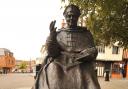
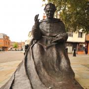
Sudbury - the Gainsborough Trail - Distance: 3.5 miles/5km
The Gainsborough Trail is a continuous walkable route of about 12.4 miles (19 km). But you can do it in sections and the 3.5 miles (5 km) Meadow Walk through Sudbury’s ancient water meadows is a delight.

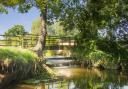
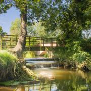
It starts in the Kingfisher Leisure Centre car park, and follows the old Stour Valley Line railway track, over Ballingdon Street, across the meadows to the Mill Hotel. The path takes you to the Croft, along the river, passing the Salmon Leap Weir, across more water meadows until you arrive at Brundon Mill and its swans. The final stage reconnects with the Valley Trail and eventually takes you past Friars Meadow and back to the starting point.
The walk reveals another side of Sudbury’s historic past and there are lots of interesting features along the way. For full details and directions gainsboroughtrail.org.uk