A South Devon walk along a wreck-rich coastline with SIMONE STANBROOK-BYRNE

Taking in one of my favourite sections of coastline, this is a superb area and Soar Mill Cove is a delightful place for a paddle if the autumn water is warm enough.
Many have passed this way before. As you walk, cast your mind back through the labyrinth of aeons. Bolberry Down has known human activity for millennia, with tools being unearthed that date back to 1500BC.
Off this coast the seas can be treacherous. Down the centuries many ships have foundered, sometimes with enormous loss of life. The area has been littered with wrecks and treasure. In the 1990s a diving team discovered gold from the wreck of a 17th century trading ship armed with cannon.

Bronze Age artefacts have also been found and one notable ship was a full-rigged tea clipper called The Hallow E’en, built in 1820. Renowned for speed, during the winter of 1874–5 The Hallow E’en sailed from Shanghai to London in a record 91 days.
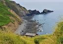
In 1887 she came to grief in Soar Mill Cove whilst importing a cargo of 1,600 tons of tea from China. There was, reputedly, a wall of tea on the beach almost 3m high.
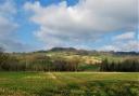
The wreck now lies in 11m of water. The first half of the walk explores attractive farmland, quiet lanes and the tranquil valley behind the coast, while the jewel in the walk’s crown, the coastal stretch, comes later.

Route:
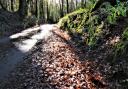
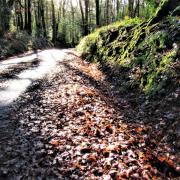
1) Start by savouring the view from the car park and then leave it along the lane by which you drove in, passing the tall radio mast in the field to the right. Gateway views on the left permit glimpses along the coast towards Bigbury and Burgh Island with its white Art Deco hotel. In about 350m you find a green lane, Jacob’s Lane, on the right, although nothing here tells you its name. Take this.
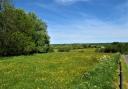
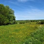
2) In 650m you reach a footpath going right through a gate to cross the land of Southdown Farm. Enter the large field and follow the right-hand boundary, glancing behind to the left where you’ll see the distinctive shape of Malborough Church. At the end of the field keep ahead between hedges, approaching farm buildings.

At a surfaced track go diagonally left across it, as the fingerpost directs, to continue on the arrowed footpath beyond. A gate leads to a path beside a National Trust hut and parking area; follow the frequent yellow arrows beyond here, the buildings of South Down Farm over to your right.
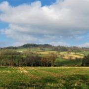
You soon reach a three-way fingerpost by steps leading down to the farm drive. Go straight across, clambering over a stone stile to join the footpath opposite. Walk ahead through the field along the line of the right-hand boundary in which occasional gaps afford lovely valley views. Look out for the craggy profile of a petrified giant poodle.
3) About 200m along this boundary you’ll see a fingerpost directing you obliquely left across the field, so strike away from the hedge towards another fingerpost visible in the distance. Salcombe can also be seen way ahead. At the fingerpost pass through the boundary and continue for almost 100m until you reach a stepped stile descending to the lane – mind how you fall down it.

Turn right along the lane, ignoring both an immediate left turn and then a left fork in just over 100m. Keep following the signs for Soar Mill Cove Hotel. You pass the attractive buildings of Lower and Higher Soar with their bright red letterbox. As you head for the hotel you pass The Olde Cottage and Hazel Tor Barn on your left.
4) The lane leads past the beach car park above the hotel and, just beyond that, the main drive into the hotel. Here you find a footpath gate ahead of you to the right, pass through and follow the yellow-arrowed path downhill towards the cove. This is a lovely stretch of grassy walking, redolent of ‘Dartmoor by the sea’.
Keep heading downhill, the path becomes stony at intervals but is always unmissable, until you arrive at the idyllic cove. Relish the area. Paddle.
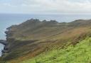
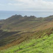
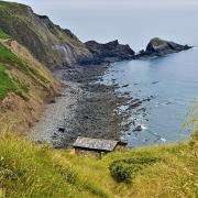
5) When you’ve had enough pick up the acorn-waymarked coast path, indicated on a fingerpost behind the beach, heading for Bolberry and Bolt Tail. Follow the path away from the cove, sea to your left. You can see the poodle again from here though it’s not her best side.

A short distance from the cove is a three-way fingerpost with a badge showing grid ref SX697377; follow the leftwards coast path with the sea to your left and ignore the more inland route. Quite a breathy climb lies ahead but the views make it all worthwhile.
Pause to glance back, it’s good there too, and partake of occasional well-placed benches. Eventually you reach a particularly finely-placed bench, engraved ‘MKW’ on its cove side; a good place to perch and feel well-pleased with the fact that you bothered. Enjoy the glorious coastal scenery, the play of light on the sea and survey the route that you’ve just travelled, back up the valley past Soar Mill Cove Hotel and across to South Down Farm. You can see from here how reasonably unobtrusive the hotel is.
Once refreshed continue on the coast path and soon the radio mast at Bolberry comes into sight again. You have good views in all directions along this stretch above Cathole Cliff.

You may also encounter rather adorable (and peaceable) Highland Cattle who help out with the habitat management along this stretch.
The path leads past an information board about the area before depositing you back in the car park from whence you started.
Ordnance Survey maps are available from all good booksellers and outdoor stores or visit our online shop www.ordnancesurvey.co.uk/al
Compass Points
Start point & parking: Bolberry Down, National Trust Car Park. Grid ref: SX688385. Nearest postcode: TQ7 3DY
Directions to start: Bolberry Down is south-west of Malborough off the A381
Public transport: No buses - sorry
Map: OS Explorer OL20, South Devon, Brixham to Newton Ferrers 1:25 000
Terrain: Tracks, field paths and coastal walking, some quiet lanes
Distance: 3½ miles/5.4km
Dog friendliness: Good, but animals grazing and exercise caution along coastal edges
Exertion: One strenuous climb but otherwise reasonably easy
Refreshments and comfort stops: What was the Port Light Inn near the start is being redeveloped as holiday homes but smart Soar Mill Cove Hotel is part-way round: phone, 01548 561566; postcode, TQ7 3DS
Info Panel: From Circular Walks in the South Hams, one of a selection of West Country walking guides from Simone Stanbrook-Byrne and James Clancy. Others include: Circular Walks in Central Devon, Circular Walks in East Devon, Circular Walks in North Devon/Exmoor, A Dozen Dramatic Walks in Devon, Favourite Walks in Devon, Town Walks in Devon. culmvalleypublishing.co.uk / 01392 881513