SIMONE STANBROOK-BYRNE takes us on a magnificently hilly seaside walk from Sidmouth
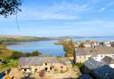
The enduring appeal of genteel, Regency Sidmouth is well known; its elegant architecture and attractive esplanade, framed by towering red cliffs, form one of the iconic views of the East Devon coast. And these magnificent cliffs offer an enticement beyond the environs of the town. Relentlessly steep, they are, nonetheless, well-walked with good, bench-rich paths that lead up into spectacular scenery.
This ‘kite-shaped’ walk visits a delightful village tucked behind the coast. The final section requires a retrace along the tail of the kite, but the views on this stretch are so glorious I hope you’ll forgive me.
Summer at the seaside can be beset with indulgent temptation – this is your chance to work it off.
The walk:
1.
From the east end of The Esplanade, opposite the Lifeboat Station, walk away from town, towards the cliffs. You’ll see the Alma Bridge, spanning the River Sid, the newest in a series of bridges and named after a battle of the Crimean War.
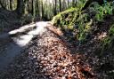
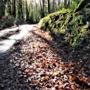
At the foot of the bridge a new South West Coast Path (SWCP) fingerpost sends us on our way: cross the bridge then zigzag uphill through a patch of woodland above the town – this section of the SWCP has been rerouted slightly inland.
The path leads to an attractive residential area; the way is well-arrowed and is also part of the Sid Valley Ring Walk. Leaving the trees, the path swings right and heads along Cliff Road; within 200m the road bends left, near a house called Coastlands. Soon you turn right again, then keep ahead walking uphill along Laskeys Lane towards a wooded hillside beyond the town.
When the road bends left go right along an arrowed track (the SWCP is depicted by an acorn symbol). Follow this, bearing left past a house and heading seawards. You reach access on the left to the National Trust land of Salcombe Hill. The best bits are about to begin.
2.
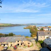
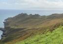
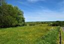
There now follows a steady uphill climb towards woodland, sea to your right. The views behind grow the higher you go; allow your gaze to wander past Sidmouth to the sandstone rock stacks in Ladram Bay and the headlands beyond – part of the 95-mile Jurassic Coast between Exmouth and Old Harry Rocks in Dorset; a coastline reflecting 185 million years of geological history.
A well-placed bench at the top of the grassy slope invites you to pause and relish it all, before continuing along the well-trodden path. Steps ascend through steep woodland. You reach an arrowed post at a crossing path; continue ahead, climbing to another post and continuing straight up from that too. The steps help you to gain height more quickly – though it may not feel like that.

3.
Eventually the path flattens out at the top of Salcombe Hill and reaches a two-way fingerpost. We will be back here later.
Turn left, leaving the SWCP and following a clear, gorse-flanked path with views to the left across Sidmouth and to the Sidmouth Gap.
Within 200m you reach a crossing path; turn left, away from the coast. In about 150m keep straight on at a four-way finger post, passing a new house over on the right called Southdown. The footpath reaches their drive; cross over and join a well-trodden path beneath trees – the garden wall of Southdown is on your right.
4.
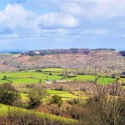
In 80m the footpath crosses a broader track; keep straight on, there’s a corrugated barn visible through trees to the right. In about 30m ignore a narrow path that forks left through trees and keep ahead. Beyond the boundary to the right is an open field and, for the moment, we’re wending our way through the edge of the woodland.
Keep straight on at another arrowed post in 160m. In another 200m the path arrives at a four-way post. Go straight across the track following the finger pointing to Salcombe Regis, half a mile away.
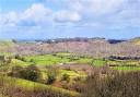
The path descends through the woodland. Reflected seaside sunlight from the right glints through tree trunks. As the path continues, we start to head inland along the tree-clad slopes of a combe.
The path emerges from the trees at a broader track and a fingerpost. Turn left along the track and follow it to the road and another fingerpost in 400m. Turn left, up the road into Salcombe Regis. Almost immediately the road passes a small round stone on the left, which looks like a milestone but I don’t think it is…what is it?

5.
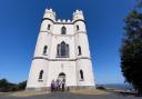
Follow the road for 100m to reach the church car park on the right. Steps lead into the churchyard and it’s a lovely amble along the path through this well-populated place to the gem of a church, dedicated to two saints: St Mary and St Peter. Originally a Saxon timber church, the present building has its roots in the 12th century and was once part of the local smuggling scene, when different kinds of spirits were worshipped.
This is a delightful place to pause and reflect. Inside are many interesting features: ancient memorials; faded wall paintings; a long list of vicars including the ‘new’ vicar, incumbent between 1307 and 1334 but given no name on the list; and a beautiful glass triptych behind the altar.
The village suffered dreadful human loss during the 14th century’s Black Death: in one year there were three different vicars. Outside, the churchyard is a living tribute to those who tend it. We picnicked on a handy bench where the sudden striking of noon from the bell tower almost made me spill the flask.
A little further up the village from the church is the Domesday Book-recorded Salcombe Thorn. Though the present tree is not the original, a thorn has been sited here as a boundary marker since Saxon times.
From the church retrace your steps down the road, passing the track down which you arrived earlier, now on your right. In another 30m you find a couple of way-markers where the road bends left.
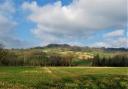
6.
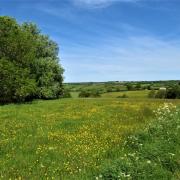
Our way now lies along the path signed to the right for Salcombe Mouth and the SWCP. Go right through a kissing gate onto a track and just before the farm gate, bear right up to another kissing gate. Follow the path beyond along the valley. The woodland we walked through earlier is up to the right. Soon the path emerges into the open valley, overlooked by idyllically situated Combe Wood Farm. Follow the path towards the sea – a glorious stretch of walking.
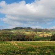
The footpath heads coastwards, passing through four successive fields, each linked by gates. After the fourth field you reach a three-way fingerpost. Take the onward SWCP option towards Salcombe Mouth (NOT left to Weston Mouth).

7.
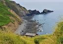
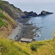
The path follows the left-hand edge of the field. A three-way fingerpost offers the chance to go down to Salcombe Mouth – if you do, come back to the coast path and continue with the sea to your left along an ever-rising path.
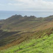
The yellow face of South Combe Farm looks across the valley to the right and, as we climb, the view behind expands. Ahead the cliff path looks distinctly off-putting, but that, I’m afraid, is our way. Keep going, think of other things, and be grateful that the steps make it slightly easier – honest.
Just when you think your legs will climb no higher, there is a bench. If anyone is already on it think kind thoughts about them and head to the one a bit higher up. From here the view east leads the eye towards Branscombe and Beer.
You’re now almost at the top. A little further and you reach a four-way fingerpost by another bench, near the large ‘frog’ stone. Mercifully, it’s all downhill from here with Sidmouth just a mile away.
8.
Follow the coast path across a flat area and past a ‘view-finder’ plinth – the view obscured by gorse when I last passed. The surfaced path bends right and reaches a familiar fingerpost in 50m. Turn left, beginning the retrace back down the steep woodland steps up which you plodded earlier.
Keep straight on down, following the coast path, to reach the open grassy area overlooking Sidmouth. This bit of the descent is one of my favourites, walking through an expansive panorama towards the town.
You re-pass the National Trust sign. Follow the track to Laskeys Lane then turn left along it (arrows guide). In 100m keep ahead on Cliff Road. Follow this as it bends about and brings you back to the path down through the trees to Alma Bridge and The Esplanade.

Compass Points
Parking: Many options in Sidmouth; I used Ham East, near the TIC (EX10 8XR), although that’s limited to four hours. Manor Road (EX10 8RR) is long-stay but at the other end of town so makes the walk longer
Start point: Eastern end of The Esplanade, near Lifeboat Station, grid ref: SY128873
Map: OS Explorer 115 Exmouth & Sidmouth 1:25 000
Terrain: Field, woodland and coastal paths, can be rough underfoot. Some road walking
Distance: Almost five miles
Dog friendliness: No stiles; animals grazing; edges along the coast; roads
Exertion: Some VERY strenuous uphill sections
Refreshments: A huge choice in Sidmouth: try Mocha (EX10 8AS; 01395 512882), on the corner of Prospect Place and The Esplanade. I also love the Clock Tower Café (EX10 8RZ; 01395 515319) in Connaught Gardens, which serves monumental cakes
Public transport: Sidmouth is well-served by buses

While you’re here…five things to do while you’re in the area
Explore Sidmouth, an historic, flower-rich town, the latter made possible by benefactor Keith Owen, who left a substantial legacy with the instruction that it should be used to keep Sidmouth beautiful, and this was to include the planting of a million flowers.
Colourful Connaught Gardens are at the elevated west end of town and were named after Queen Victoria’s son, the Duke of Connaught, who visited the town where his grandfather died.
Take tea and dip into gentility at one of the smart hotels in town. One of my favourites is the Victoria where you can indulge in the full works of ‘proper’ afternoon tea – but ring to book first and scrape off any mud before you arrive.
The Lockyer Observatory is a wonderful place just outside Sidmouth. Founded by astronomer Sir Norman Lockyer (who is buried at Salcombe Regis) it is the home of many intriguing scientific artefacts including (my favourite) an elegant, fully working Victorian orrery.
The Donkey Sanctuary shouldn’t be missed. Not far from Salcombe Regis and free to visit, the place is full of adorable donkeys and also has an excellent restaurant.