
Lindsay Want tracks down Lowestoft’s industrious past on a station to seaside walk

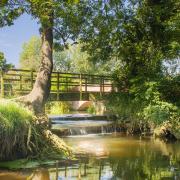
Alight at Oulton Broad’s south station and find yourself in a delightful dilemma. In one direction is the wild world of Carlton Marshes with tales of bogbeans, great Fen Raft spiders, and soaring marsh harriers. In the other, life seems simply a walk in the Nicholas Everitt park.
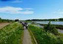
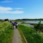
West, the River Waveney beckons ramblers along its banks and the Angles Way for a 10-mile stride to Beccles. But what lies east, outside the beautiful Oulton Broad-side walk-ways of the park? Follow the North Lowestoft footpaths and just four miles of gentle urban exploration and unexpected green spaces later, you’ll find refreshing sea-views and sand between the toes. Along the way you’ll be transported back in time.
Secrets of Lake Lothing
Who can tell how many people, over how many centuries have stood on a bridge at Oulton Broad and looked out across the water. The ‘Broad’ bit is a relatively new addition, created after things got chilly in the 13th century.

Generations of Suffolk ancestors dug out peat by the cartload, then abandoned the shallow exhausted pit to fill with water. You’ll find the whole story, and much more, at Lowestoft Museum, in Nicholas Everitt Park.
Gaze eastwards from the ancient crossing and meeting point of Mutford Bridge (moot-ford bridge) and it’s a different story. Suffolk boasts few lakes, but this is, apparently, one of them.
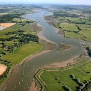
Thanks to the floods and tides of time, long-shore drift and human endeavour, Lake Lothing has had to go with flow of now fresh, now salt waters and seen its identity shift from deep creek, to enclosed lake, to its current state of well-protected, yet open-to-the sea harbourlands. No wonder its unusual name has overtones of general disgruntlement.
A lock at Mutford Bridge safeguards Oulton’s broad from a similar salty fate and, together with Oulton Dyke and Haddiscoe Cut, allows vessels to sail from Lowestoft upriver to Norwich, bypassing Great Yarmouth. By the Wherry Hotel, it’s tempting to sit back and sip a while, but duck and dive by bascule bridges and tunnels, alongside jetties, boatyards and marinas and you’re soon on the edge of a different watery world, standing by the slipways of what was once the leading timber shipbuilding port of England, watching oystercatchers dip and stride, cormorants perch and herring gulls fish about for their supper.

It’s a haunting place, still rippling with secret stories of wartime torpedo boats repaired in the shipyards, of tethered tank-training craft, and doodlebugs cruising in from Corton to land in the lake, yet damaging windows over a mile away.
Massive concrete anti-tank landing blocks still dot the landscape. Lake Lothing may seem a fish out of water, but its banks still resound to the intermittent bangs and clangs of boatbuilding and there’s a sense that it has been a key mover and shaker for centuries. In the Domesday Book you’ll find Lowestoft recorded as ‘Lothuwistoft’.
Swing inland behind Leathes Ham and just a green and pleasant stroll through Normanston Park away, North Quay Retail Park is home to Lowestoft’s first ever bus depot in 1912. This site soon became Eastern Coach Works Ltd, the town’s largest full-time employer by 1936.
Come wartime, it was hardly prudent to have fleets of wheeled vehicles lined up and waiting for an invading army to jump on board, so production halted. By 1947 business was going full throttle again and even into the 1960s, the sight of a be-goggled delivery driver daring to ride a bus chassis ‘bare back’ through the streets of Lowestoft, hardly attracted a turn of the head. The town’s love affair with such impressive body-builders sustained into the 1980s.
 Crown copyright 2018, Ordnance Survey, Media 003/18")
If only North Lowestoft’s railway line had been so lucky. At least there’s plenty to remember it by. Alongside the old coachworks site, the Great Eastern Linear Park picks up part of the old line from Lowestoft Central, stretching along an open cutting towards Yarmouth Road and the Denes. It’s a pretty, wide and straightforward path along the track-bed, just right for walkers and cyclists.
In the 1950s, long trains like The Easterling left Liverpool Street station on summer Saturdays, packed with excited ‘hol’dee-makers’. First stop Lowestoft Central, then it reversed to head up to North Lowestoft station’s extended platforms close to the holiday camps by The Denes, before continuing via Gorleston-on-Sea to Yarmouth. The station closed in 1970, but you can still spot the stationmaster’s house on the corner of Station Road, as you head towards Gunton Cliff and North Parade for a first glimpse of sand and sea.
Life’s a beach
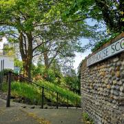
Or a Sparrow’s Nest. Across the brightly painted bridge commemorating Victoria’s jubilee, the poignant towering war memorial in Belle Vue Park stops you in your tracks. Steps lead down into a nest of garden terraces, cafés, museums, a bowling green, open stage, ponds and play places all set beneath the white lighthouse.
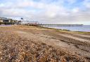
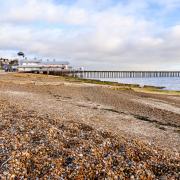
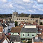
The Sparrow’s Nest is the last gloriously green spot before tales of ‘beach companies’ and the massive ‘Beach Village’ fishing community unravel by the old net-mending posts and abandoned anchors near the seawall. By Ness Point, where the sun rises first, bustling South Beach beckons across the harbour in the distance. Inland, the steep, narrow ‘scores’ leading up to old town Lowestoft suggest a past just waiting for a new dawn.
And out to sea, great Gulliver, the 126 metre wind turbine, stands testimony to an industrious place, determined to keep wheels turning and happy to keep on reinventing its ways.
The walk
1 Start at Oulton Broad South railway station. Go left over the bridge and into Marsh Road. Go right. Enter Nicholas Everitt Park via car park. Take the path along the edge of the Broad.
2 Pop in or pass Lowestoft Museum, then the harbourmaster’s office. At the road, turn left.
3 Cross the bridge over the lock. Take the pedestrian underpass. The path bends left with views of boatyards on Lake Lothing. At the road, turn right down a footpath between two fences. Go under the railway line to Lake Lothing. Waymarkers lead through boatyards, past the International Boatbuilding Training College, the marina and onto lakeside path.
4 At the anti-tank blocks, turn left to take steps up and over the railway footbridge.
5 Follow the path into Normanston Park and to Peto Way. Cross the road and take the footpath straight ahead, past Princes Walk and continue to a footpath junction.
6 A sign marks the start of the old Yarmouth-bound railway line. On the right, the former Eastern Coach Works site, now part of North Quay Retail Park. Go left (‘Gunton’) along the old track-bed through Great Eastern Linear Park, emerging up from the cutting onto Yarmouth Road.
7 Cross over. Turn right, then left into Station Road, right at Corton Road, left into Lyndhurst Road. At the end, go right onto cliff-top North Parade.
8 Continue on the path which bends right to the iron footbridge into Belle Vue Park.
9 By the lofty naval memorial take the steps down into Sparrow’s Nest Gardens.
10 Follow path right, past Lowestoft War Memorial Museum. Exit the park at the gate by Lowestoft Maritime Museum onto Whapload Road. Turn right, passing Lighthouse Score. Cross to take Heritage Trail to the sea wall, turn right and continue down Lowestoft Ness.
11 The ‘Euroscope’ compass at Ness Point marks England’s most easterly point. Continue to the end of the sea wall. Go slightly right to take steps over the sea defences into Hamilton Road.
12 Go down Hamilton Road to the roundabout. Head diagonally into Gordon Road. At London Road N go left and continue to Lowestoft Central Station 13.
Distance: 4 miles/6.5kms
Time: About 2- 2.5 hours
Start: Oulton Board South train station
Getting there/back: nationalrail.co.uk suffolkonboard.com
Street parking: near station. Car park at Nicholas Everitt Park
Finish: Lowestoft Central train station for return to Oulton Broad.
Access: Urban footpaths, at times close to water’s edge. Mainly tarmac paths/pavements. Steps. Fully waymarked
Ts & Ps: Cafes, pubs, toilets along the route
This East Suffolk Line walk devised by Roger Wolfe is one of 20 featured in a free publication republished for the 50th anniversary of the Ipswich to Lowestoft East Suffolk Line’s reprieve from the Beeching cuts, a fitting tribute to the East Suffolk Travellers’ Association who fought to save the line from closure.
The free East Suffolk Line Walks publication with clear directions and mapping is available from Tourist Information Centres and downloadable at eastsuffolklinewalks.co.uk or eastsuffolkline.com/walks.
Free guided walks from the East Suffolk Line and Felixstowe Line, led by volunteers, are a great way to enjoy town and countryside with like-minded folk. Open to all, they are occasionally themed and booking is not normally required.
Walks are from station to station, or have suggested public transport options for return journeys.
For details eastsuffolkline.com/walks
Don’t miss museums along the way: Lowestoft Museum (free) lowestoftmuseum.org
___________