SIMONE STANBROOK-BYRNE follows in the footsteps of Exmoor’s legendary lovers and the notorious Doone clan

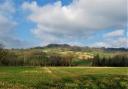
Wild, high and remote, Exmoor straddles the Devon-Somerset border, the majority of the moor being in Somerset - although this walk stays in the 29% that is in Devon.
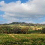
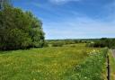
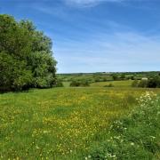
This primal landscape rises to wind-blasted heights and plummets into deeply-folded combes. Occasional burial mounds remind us of lives long-gone. Such sparsely-populated isolation feeds the imagination; folklore and legends are born.
So it is no surprise that the atmospheric moor, beloved by 19th century novelist R.D. Blackmore, was the setting for his most successful novel, Lorna Doone, in which real events and people were blended into an intriguing meld of fact and fiction.
The names of existing families were used in the book and tradition told of an outlawed Doone clan settling on Exmoor in the 17th century.

In the novel the main character, John Ridd, falls in love with the eponymous heroine but, inevitably, all does not run smoothly since she belongs to the notorious and marauding Doones who murdered his father.
This serious impediment somehow doesn't diminish his ardour and after much skirmishing and violence things work out in the end (of course).
With its connection to this enduring novel, Malmsmead and its historic packhorse bridge is always a popular area, but away from the village and up on the windswept moorland the countryside can feel remote and isolated.
It is an historic land of sudden mists and lonely sequestered places, where memories and dreams may merge and the ghosts of long-dead lovers might just be walking with you....

Route
1) Walk out of the car park behind the gift shop and turn left, quickly reaching a junction of lanes. Opposite you see a gate with an honesty box. This gives access to a path across private land which the owner is happy to permit, for a small fee.
I recommend this start, but if you prefer to walk up the lane to the right for about ¼ mile you will find access to a bridleway, signposted Badgworthy Valley, ½ mile, which will eventually lead you to (*) below.
For those paying the fee and taking the first option, walk ahead on the path (heading south). The river on your left is Badgworthy Water and at this point it is the boundary between Devon and Somerset. Soon you see the farm buildings of Cloud Farm ahead to the left.

Just over ½ mile from leaving Malmsmead the path leads through a gate to cross a small stream (less small, after heavy rain!). From this point walk ahead across the grass to a fingerpost. A bridlepath comes in here from the right along which those who avoided paying will approach (*).
2) Now keep ahead in the same direction along the bridlepath, ignoring the left turn across the footbridge to Oare Church (where John Ridd and Lorna Doone were married), and heading more deeply into the Doone Valley.
Soon you pass a memorial stone erected in 1969 by the Lorna Doone Committee to the memory of R.D. Blackmore. As the path forks keep left to continue near the river, although the paths soon merge again. In summer this area is buzzing with swallows.
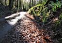
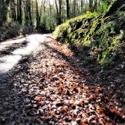
Less than ½ mile from the footbridge the path enters Yealscombe Wood, soon followed by Badgworthy Wood. Keep ahead on the main bridlepath ignoring any tracks up into the trees. After some way through the woods you reach a river crossing called Sir Hugh's Ride. This is a permitted bridlepath and horses can wade through the river here, but your way lies ahead without crossing, keeping the river to your left.

About 100 metres beyond Sir Hugh's Ride the path emerges from the trees. Keep ahead on the same bridlepath, ignoring the broad track sweeping round to the right. The river is now slightly further away to your left but soon curves in again and you are once more walking amongst trees. The path crosses a footbridge over a tributary stream, a pretty area, then continues ahead as before.
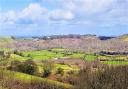
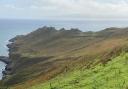
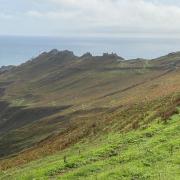
The bridlepath eventually climbs a little, still keeping the river to the left and passing occasional blue bridlepath markers. The view opens up across the valley; this is all Doone Country and to the left is the huge, treeless mound of Deer Park.
3) Almost ½ mile after leaving the trees the bridlepath takes a distinct right turn. This region is the site of a deserted medieval village - perhaps the erstwhile home of the Doones. The walk follows this bend, although it is worth first visiting the delightful area down to the left on the permitted path which leads to the river, from which you have good views in both directions along the Doone Valley.
Back at the bend you soon see a waymarker showing that your way leads to Brendon Common. Left is to Tom's Hill, which you ignore. The watercourse which is now down to your left runs through Hoccombe Coombe. Keep on the blue-marked bridlepath as it takes you in a generally north westerly direction across moorland (although the path bends a bit you are on a bearing of approximately 310º).

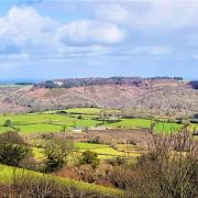
4) About one mile from the right hand bend and waymarker, pass through a gate with a fingerpost which reassuringly indicates that you are still on the bridlepath (Grid ref SS781452). There are superb views from here.
Keep on the clear track for another ¾ mile until the path descends to cross Lankcombe Ford. Beyond here head up the hill on the right-hand of the two distinct paths. A sign here requests that you keep to this, the main track, which heads very slightly east of north from the ford. This is a moorland conservation area.
5) You soon see a fingerpost ahead at a crossing of ways. From here turn right towards Malmsmead on the clear track enjoying more fabulous views.

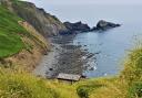
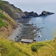
6) Just over ¾ mile from the crossways you see a gate on your right and the track takes a distinct left turn (SS780465). Go with this. There is a ford here after wet weather but it is often dry and invisible. Follow this track, the sea eventually comes into view ahead of you and to the right.
The track leads to the lane in just over ½ mile. Turn right and follow the road back down to Malmsmead and your car.
Ordnance Survey maps are available from all good booksellers and outdoor stores or visit our online shop www.ordnancesurvey.co.uk/al
Look out for
- Superb views
- Blackmore memorial
- Many birds
- Ghostly Doones
Important: For this route walkers need to be conversant with the use of a map and compass and comfortable with moorland navigation. GPS useful if you have one. Clear weather vital and please be well-shod
Directions to start: Malmsmead is on Exmoor on the Somerset border. It can be accessed off the A39, 5½ miles east of Lynmouth
Parking: In Malmsmead, behind the gift shop. Grid ref: SS792478. Postcode: EX35 6NU
Start Point: Malmsmead car park behind gift shop
Public transport: None
Map: OS Explorer, OL 9 Exmoor 1:25 000
Terrain: Paths and open moorland. Stretch of moorland road at the end
Distance: 6½ miles (10.5km)
Dog friendliness: Good, but watch they don't chase the wildlife
Exertion: Moderate to strenuous
Toilets: In Malmsmead
Refreshments: The Lorna Doone Inn, Malmsmead, EX35 6NU (01598 741450)
Simone Stanbrook-Byrne, with James Clancy, has produced a selection of West Country guides including: Favourite Walks in Devon, Circular Walks in the South Hams, Circular Walks in East Devon, Circular Walks in Central Devon, Circular Walks in North Devon/Exmoor, A Dozen Dramatic Walks in Devon, Town Walks in Devon. culmvalleypublishing.co.uk / 01392 881513