

Getaway from the crowds this summer.
South Dorset Ramblers share some favourite summer walks that take you far from the madding crowd on the coast and explore some of the county’s beautiful inland routes, along the way taking in ancient landscapes, pretty villages and breath-taking vistas.
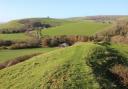
SYDLING ST NICHOLAS & WESSEX RIDGEWAY
6.5 miles/10.4 km, moderate circular walk, 3 hours
OS Explorer OL15, Route via Ramblers Routes

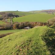
Sydling St Nicholas is a small, but picturesque village located in the valley of Sydling Water, a tributary of the River Frome. The valley is one of several, which cut into the surrounding chalk hills and form part of the Dorset Area of Outstanding Natural Beauty (AONB). The village contains many noteworthy, thatched cottages in the traditional brick and flint construction. Look out for the old petrol pump on the High Street, it marks the location of the village’s former shop and post office.

The name 'Sydling' is from the Old English sid and hlinc, which mean broad ridge and refers to the hills surrounding the village. The church of St Nicholas, from which the village derives the second part of its name, dates to the 15th century, albeit there were earlier buildings on the site. The porch contains an unusual fireplace, around which village meetings were once held.

The valley sections of this walk take in the pretty village, roadside streams, and a beautiful farmhouse. The downland sections give wonderful expansive views over the surrounding valleys and villages. This walk is particularly delightful in sunny weather where the colours of the fields and woods are stunning.
Drinks and excellent locally sourced food (plus overnight accommodation if you want it) are available at The Greyhound Inn on the High Street in Sydling St Nicholas (dogs welcome).
An ascent and descent of around 570 ft, with one long hill up and one down, neither of which are very steep. No stiles, just a few gates.
Click here for the route for this walk

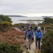
UPWEY AND THE SOUTH DORSET RIDGEWAY
6.2 miles/10 km, moderate circular walk, 3 hours
OS Explorer OL15, Route via Ramblers Routes
A favourite walk of South Dorset Ramblers, this circular walk from Upwey Wishing Well takes you out along the Ramblers Jubilee Trail to Friar Waddon and Corton Hill and then climbs to return via the South Dorset Ridgeway.

The delightful small Chapel of St Bartholomew at Corton and the stunning panoramic views over Weymouth Bay, Portland and the Fleet are not to be missed. Keep your eyes peeled for wildlife, you may see hares racing across the landscape or red kites circling overhead.

Upwey Wishing Well is a natural spring. The tradition of a wishing well is said to have begun as a visitor attraction in the early 20th century. Visitors would often participate in the ritual by taking a few sips of well water from a glass and throwing the rest of the water backwards over their left shoulder whilst making a wish. Now operating at Upwey Wishing Well, Water Gardens & Tea Room, they are open daily serving coffee, light bites, lunches, and afternoon tea.
The 90-mile Dorset Jubilee Trail was established by the Ramblers in 1995 to celebrate the organisation’s 60th anniversary and take walkers to lesser-known delights.

The return route is along the South Dorset Ridgeway, which was ritually and culturally important to the people of the Neolithic period. It is often referred to as a ‘ceremonial landscape’ owing to rare Neolithic earthworks dating from about 3,600BC and the large number of later Bronze Age burial mounds. From the Ridge you can also see the remains of the Iron Age hillfort of Maiden Castle.
A rewarding but hilly walk with one long steep climb and an ascent and decent of about 230 metres.
Click here for the route for this walk

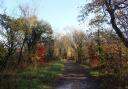
WOOL, COOMBE HEATH & THE HARDY WAY
5.7 miles/9.1 km, leisurely circular walk, 3 hours
OS Explorer OL15, Route via Ramblers Routes
The walk starts in Wool, quite a large, picturesque village, which lies between the River Frome and a ridge of hills separating it from the main tourist attractions of Lulworth Cove and Durdle Door on the Jurassic Coast.
The name 'Wool' derives from the Saxon 'Wyllon' signifying a well or spring. Water from the spring continues to tumble off the chalk ridge, forming a picturesque stream that flows past the thatched cottages in Spring Street and across the water meadows to join the River Frome.
From the Church of the Holy Rood, the walk follows the Hardy Way across the meadows (which can be rather boggy after rain), to Bindon Abbey (now a wellness retreat) and passes through East Stoke Fen Nature Reserve and on to East Stoke.

After passing through Highwood the route follows the perimeter of the Military Firing Range at Coombe Heath Nature Reserve, where you have expansive views across the Purbeck Hills. If you are lucky, you may spot a tank or other military vehicle. You will almost certainly hear machine gun fire. The walk then crosses heathland before passing through various stands of deciduous and coniferous trees back to your starting point.

Whilst there are several public houses in Wool, The Black Bear, a CAMRA award-winning free house and restaurant serving homemade locally sourced food and cream teas, is just 100 yards along the High Street. The manager has confirmed that anyone quoting this walk may have free access to their toilets, on request.’
Click here for the route for this walk

BROADWINDSOR, PILSDON PEN & LEWESDON HILL
6.6 Miles/ 10.6 km, strenuous walk, 3 hours 15 minutes
OS Explorer 116, Route via Ramblers Routes
Whilst more strenuous than most Dorset walks, as the route includes two steep climbs, it is a favourite of the South Dorset Ramblers Group and a wonderful walk for nature lovers, historians, and archaeologists.
The walk begins in the pretty village of Broadwindsor, whose main claim to fame is that on the night of September 23, 1651 it gave shelter to the fugitive King Charles II after the defeat of the Royalist army at the Battle of Worcester. Look out for the plaque on a cottage wall inscribed 'King Charles II slept here'.
The route follows parts of The Monarchs Way (a 625-mile long-distance footpath running from Worcester via Bristol and Yeovil to Shoreham in West Sussex that approximates the escape route taken by King Charles II after his defeat) and the Dorset Jubilee Trail (a 90-mile route established to celebrate the 60th anniversary of the founding of the Ramblers' running from Forde Abbey on the Somerset border in the west, across Dorset to Bokerley Dyke on the Hampshire border), whilst ascending the two highest hills in Dorset, Pilsdon Pen and Lewesdon Hill, and visiting their iconic hillforts. At times, the paths are very uneven, overgrown, and very muddy, so perhaps this route is more for the experienced walker.

From the top of Pilsdon Pen you have panoramic views of Golden Cap and the sea to the south, Hardy Monument to the east, Exmoor and the Quantocks to the west and the Mendip Hills to the north, making the climb of 909 feet (277 metres) well worth the effort. This is a good place for a picnic, near the Trig point, weather permitting.

Before climbing up to Lewesdon Hill, 915 feet (279 metres), a settlement since the Iron Age, you will walk through ancient woodlands with beech and oak trees, some over 200 years old. A haven for wildlife.
There are no public toilets on this route, but refreshments can be found at the White Lion the village’s 17th-century inn or Redlands Yard (formerly Broadwindsor Craft Centre) in Redland Lane, which has The Stableyard Restaurant offering breakfast, lunch, light bites and afternoon tea. There is also a village shop, Broadwindsor Community Stores, next to the parking layby if you wanted to stock up on provisions for a picnic.
Find the route for this walk at Ramblers.org.uk/broadwindsor

PUNCKNOWLE & WEST BEXINGTON
5.7 miles/9.2 km, moderate circular walk, 2 hours 30 mins
OS Explorer OL15, Route via Ramblers Routes
Beginning in the small village of Puncknowle (pronounced ‘Punnel’), with its charming stone cottages and farm buildings, this walk of 5.7 miles (excluding the possible 0.8-mile extension to the ruins of Abbotsbury Castle) will probably seem longer due to its hills and the section of shingle beach. Also, certain parts can be very muddy after periods of rain. However, your efforts should be rewarded with varied inland scenery, local wildlife, and superb views of the Jurassic Coast.

On leaving Puncknowle you climb up from the village through a leafy lane towards the Knoll Planation, reaching the restored Coastguard House on the Knoll with its excellent views over Lyme Bay and Golden Cap on the coast and inland to the West Dorset hills.

The walk continues along farm lanes and across fields to reach the South Dorset Ridgeway. At this point you can take an optional short detour to the site of Abbotsbury Castle, an Iron Age hillfort, where there are stunning views over St Catherine’s Chapel and the Fleet. On progressing westwards, you pass a restored lime kiln before dropping down to the small coastal village of West Bexington, surrounded by National Trust lands. There are toilets here and an opportunity to partake of some food and refreshment (The Manor House, The Club House also Tamarisk Farm Shop).

On reaching the sea, the route turns west again running along the rear of the shingle beach past the West Bexington Nature Reserve, before returning inland across the fields to Swyre and then on along a shady lane and open fields back to Puncknowle, where the 16th century Crown Inn provides a further welcome opportunity for a well-earned drink and nourishment.
Find the route for this walk at Ramblers.org.uk/puncknowle

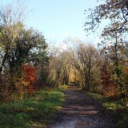
TOLPUDDLE, BRIANTSPUDDLE & ATHELHAMPTON
8.2 miles/13.2 km, moderate circular walk, 3 hours 30 mins
OS Explorer OL15, Route via Ramblers Routes
This lovely walk provides a good mix of local history, pretty villages and contrasting countryside. Starting from the village of Tolpuddle, the walk takes you through farmland and over the River Piddle before arriving at the village of Briantspuddle. It then climbs up through woodland to Culpeppers Dish and the Affpuddle Heath car park and picnic area, before continuing along rhododendron-lined tracks through woods and heathland to arrive at Athelhampton.

The final stretch follows well defined tracks along the Piddle Valley back to Tolpuddle, passing the Martyrs Tree and the Memorial Shelter.
The ‘model’ village of Briantspuddle, enlarged and developed by a member of the Debenham family, contains many noteworthy, thatched cottages and a fine village hall, where residents provide refreshments.

The walk passes close to Culpeppers Dish, the largest of several swallow holes, also known as ‘dolines’, located on the route. They are formed by the collapse of overlying rock into an underground cave or chamber.


Returning to Tolpuddle you pass the Martyrs Tree, an ancient sycamore believed to be 340 years old. In 1833 six agricultural workers met underneath the tree to discuss their unfair pay and working conditions. A year later the men were arrested, sentenced, and transported to Australia. They became known as the Tolpuddle Martyrs and ever since the tree has been the symbolic home of the modern-day trade union movement. The Martyrs’ Museum is located 400 yards away visit tolpuddlemartyrs.org.uk for opening times.
Find the route for this walk at Ramblers.org.uk/tolpuddle
With thanks to the Ramblers South Dorset Group and particularly to those members who helped with the six featured walks, namely John Pennington, Chris and Sarah Moyle, Sally Morgan, Sheila Couch and David Price.
The Ramblers’ Walk Your Way Campaign: The Ramblers are encouraging everyone to Walk Your Way and experience the joys of being outdoors. This summer campaign offers free, downloadable walking inspiration packs to help you get more out of walking in the countryside, whatever your experience. These include area specific things to look for on your route and tips for summer walking, download free at ramblers.org.uk/walkyourway
Join the Ramblers: If you’re new to walking, joining your local Ramblers group is a really easy way to get started – walks are all planned for you, and there’s always a ‘back marker’ walker on Ramblers group walks, so no one gets left behind! There are over 500 Ramblers groups across the country, in Dorset the local Ramblers groups include: North Dorset, South Dorset, East Dorset, West Dorset, Bournemouth Happy Mondays Ramblers - walks every Monday 10am (except bank holidays) within an hour's drive of Bournemouth, Dorset 4050 Walkers (any age), and Dorset Young Walkers (aimed at 20s and 30s). You don’t have to be a member to join a walk, click on ‘find a group near you’ search facility at ramblers.org.uk.
Looking for a walk? Ramblers Routes online collection of well over 3,000 walk routes across Britain of three miles’ length and under, is free to access (you just need to register) ramblers.org.uk/walksfinder.