SIMONE STANBROOK-BYRNE takes a walk exploring fragments of history along the beautiful South Hams coastline

Details of the very earliest settlement at Hallsands are shrouded in the sea mists of history. It is an intriguing place. From the old bones that remain clinging to the cliff, it is hard to envisage that during the 18th–19th centuries this tiny fishing village had expanded to almost 40 houses, including an inn with stables, that brewed its own ‘white’ ale, and a shop and post office. The 1891 census tells us that there were 159 inhabitants most of whom owned their property having bought it when the previous owner of the estate died.
However at the end of the 19th century life here suddenly became terribly precarious. Devonport Dockyard near Plymouth was expanded, a project requiring a huge quantity of raw materials such as sand and gravel. Dredging for these was carried out near Hallsands.
The villagers were concerned for the safety of their homes as the beach began to drop away, leaving the village more exposed to high tides. They voiced strong objections but dredging was permitted to continue until 1902. Once it ceased the level of the beach started to recover but the village’s defence against violent seas was badly impaired and subsequent storms over successive winters caused much damage. Finally, a fierce storm in January 1917 devastated the village leaving only a couple of the higher houses usable.
The last resident was the resilient Elizabeth Prettejohn who lived here until her death in 1964 aged 80.
The ruins and their memories are a sad memorial to victims of industry, but the coastal walking is superb with big skies and expansive sea views. We saw more stonechats on this walk than on any other – listen for their ‘chinking’ call, it sounds like pebbles being tapped together. You may also be treated to the aerobatic wheelings of starlings. Enjoy!
Route:
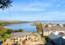
Leave the car park and turn right down the lane, passing the complex of Prospect House with its various mews apartments on your left. The lane climbs and as it starts to go left downhill look for the access on the right leading down to the viewing platform above the ruined village. From it you can see what’s left of old Hallsands – a collection of information boards explains the history of the homes that were sacrificed on the altar of commercial enterprise further along the coast.
Climb back up the slope towards Prospect House to where a fingerpost indicates the coast path. Go left to join it, walking away from Prospect House, sea to your left, towards Start Point and its lighthouse, 1¼ miles away.
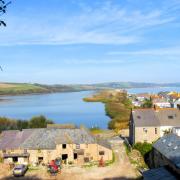
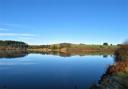
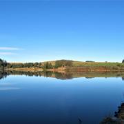
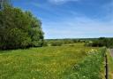
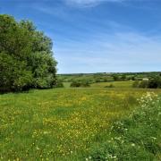
The path becomes more open, enjoying fabulous coastal views. Remember to look behind, across the Dart Estuary towards Froward Point; if conditions are clear, you may make out the daymark tower on top of the headland. Also in that direction lies the long expanse of Slapton Sands and, behind it, Slapton Ley, the largest, natural freshwater lake in South West England.
The path leads unerringly into Start Point Car Park above the lighthouse. Pass through the large gates (or cross the adjacent stile) to a three-way fingerpost and from here head down the now-surfaced coast path towards Lannacombe.
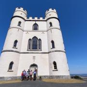
At the next three-way fingerpost (2a) you have an option; to see the lighthouse keep going downhill to Start Point, although you will need to return to this point to continue with the coast path. The solid lighthouse commands a wonderfully isolated spot and at times is open to visitors (details from startpointdevon.co.uk). It is administered by Trinity House, an historic charity that originates from a fraternity of seafarers called The Guild of the Holy Trinity. This guild regulated the pilotage of shipping in waters used by Henry VIII and the charity received a Royal Charter in 1514. It still has an important role today.
Return back up the path to the fingerpost and turn left, leaving the surfaced path and striking out across the cliff towards Minehead, 462 miles away in Somerset at the end (or start) of the South West Coast Path.
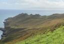
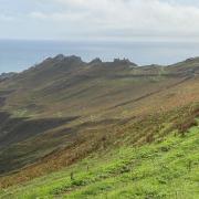
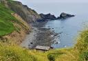
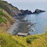
You swiftly crest the ‘spine’ along the headland, at which point a superb panorama awaits. Savour it, then continue on the yellow-arrowed, acorn-waymarked coast path, sea to your left – a fabulous stretch of walking across an area known as ‘The Benches’. The path is clear and occasionally rocky; keep going until you round the headland and the view across Lannacombe Bay opens up ahead with Prawle Point, the most southerly part of Devon, jutting into the sea beyond.
Once the view across the bay is revealed keep following occasional coast path posts. After about 200m you reach one with a yellow hat whose badge indicates Pear Tree Cove (grid ref SX819367). From here look ahead to where the path forks in 100m, beyond the fork is a bench. The right-hand fork is your onwards route but first relish the bench with its view over Great Mattiscombe Sand; note its dedication to John Barlee, a naturalist and ornithologist “who loved this place”. We met a couple whose dog once fell over the cliffs here – 14 coastguards rescued him and he lived to tell the tale.
A path near the bench leads down to the beach but the walk heads inland to a three-way fingerpost in a short distance, where the coast path continues to the left.
Here you leave the coast path and continue inland back towards Start Point Car Park. Pass through a gate in about 50m then continue along the side of a pretty coastal valley, the path is well-trodden.
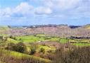
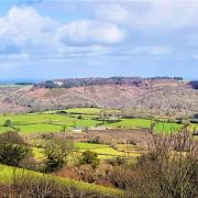
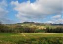
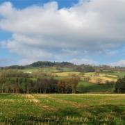
After almost half a mile you arrive back at the car park; go through the gate/over the stile then leave the car park along the lane, passing the entrance to Start Farm and its nearby twin masts. There are excellent inland views along this stretch of lane walking, shadows chase across the landscape and far in the distance you can see Dartmoor. The lane passes ivy-clad ruins on the right about half a mile from Start Farm, and about 200m further on you reach the junction of Hollowcombe Head Cross.
Turn right towards South Hallsands and in 100m the lane forks. If you wish to take a shortcut back to the car take the right fork, otherwise go left towards Lamacraft House. The lane leads down to Lamacraft House and Cottages. Look out for the lovely stone horse trough on the left with a pennywort-clad wall behind it. The arched gate to Lamacraft House is in front of you and the lane bends sharp right. Keep following it and it soon swings right again to pass behind buildings, at which point don’t go right but look for the small gap in the wall straight ahead.
Go through this gap onto an earth and stone path heading downhill between trees, away from the buildings. This path descends for about quarter of a mile before depositing you in the environs of some rather lovely houses near a two-way fingerpost.
Take the right-hand option heading uphill on a broad track, passing Orchard House. The track leads through a gate into a field. Walk through the field with the boundary and sea views to your left. The path descends to reach a stile, beyond which is the lane and car park from which you started. w
Next month we head for West Dartmoor
Compass points...
Start point and parking: Car parking area on the edge of South Hallsands with honesty box. Grid ref: SX816384. Nearby postcode: TQ7 2EY
Directions to start: Hallsands is on the coast, south of the A379 in South Devon, 13 miles from Dartmouth
Public transport: None
Map: OS Explorer OL20, South Devon, Brixham to Newton Ferrers 1:25 000
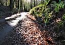
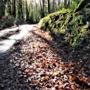
Terrain: Coast path, lanes, footpaths. Sometimes rough underfoot
Distance: almost 4¾ miles/7.6km
Dog friendliness: Good, but livestock may be grazing
Exertion: Moderate: there are ups and downs and mud after wet weather
Toilets: None en-route
Refreshments: Take a picnic as the walk doesn’t pass any inns. The excellent Britannia @ the Beach is 1½ miles up the coast at Beesands (just over three miles by car): 01548 581168
Look out for:
‘Lost’ village of Hallsands
Start Point lighthouse
Seals basking on rocks
Variety of birds