SIMONE STANBROOK-BYRNE finds places to walk where we can also enjoy birdwatching
To the east the sky is just lightening; the day beginning to point towards morning. Listen! Very gradually, growing from a few tentative voices, the dawn chorus begins. It would take a sad, dark soul indeed not to be moved by this aural delight.
Now is a great time of year to get out there and see what the birds of Devon are up to, and we are well-served with places to watch them. Here are a few sites which can also be incorporated into a good walk, as any stroll is always enhanced by engagement with nature.
What you see will depend on the time and season of your visit and the conditions; you may have an appointment with nothing at all, or you may be lucky – the birds I mention are only a fraction of what might appear. And. In my opinion, anything you see is worthwhile – there is nothing ‘only’ about a sparrow or any other ‘little brown job’ – they are all little miracles of evolution and engineering.
Here's my round-up of 6 of the best walks for birdwatching in Devon:

Haytor, Dartmoor
One of the iconic tors of Dartmoor, this muscular granite outcrop and its surrounding moorland offers a range of habitats. You would be unlucky not to hear cuckoos in late spring and curlews and lapwings breed in the area.
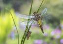
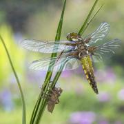
Nearby are the now-tranquil pond areas of former working quarries where you might spot a tiny and delightful firecrest, though commoner birds are more likely such as tits, robins and wrens. Stonechats, wheatears and whinchats sometimes use crags and gorse bushes as vantage points. Keep an eye on the sky for swallows and skylarks – and listen for the cronk of ravens. Away from the summer months there is a good chance of encountering a flock of golden plover on the moorland near the tor.
Walk: If you stray far from the tor you will need to be happy about wandering open moorland – so pick a fine day. Granite tramways cross the moor around here, remnants of the age of industrial quarrying, and these make for easy paths to follow. Otherwise, take a map and compass/GPS, and explore the old quarries or head west down to Becka Brook, between Haytor and Hound Tor. You can opt for as long or short a walk as you wish.
Map: OS Explorer OL28 Dartmoor 1:25 000
Parking: Dartmoor Visitor Centre Pay & Display car park (Nearby postcodeTQ13 9XT; Grid ref: SX765771)

Fremington Quay, North Devon
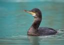
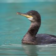
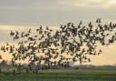
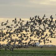
For centuries the Fremington area was a place busy with the clay industry but after its decline the railway sidings were removed and the quay fell into disrepair. Now the mudflats of Fremington Pill provide a rich source of food for wading birds – I saw more redshank here in one go than I’ve ever seen before plus plentiful lapwings, little egrets and shelducks.
Rarer treats in the area may include a spoonbill and an occasional glossy ibis. The tree-flanked paths away from the water are good for siskins, song thrushes, long-tailed tits and other more regular birds.
Walk: Fremington Quay Café makes an enticing start and end point for any walk. The excellent Tarka Trail goes right past, following the former railway line and offering miles of walking (or cycling) through the countryside celebrated in Henry Williamson’s enduring novel, Tarka the Otter. A suggested three-mile circular route follows the Tarka Trail eastwards, then footpaths through farmland to join the byway alongside Fremington Pill.
Map: OS Explorer 139 Bideford, Ilfracombe & Barnstaple 1:25 000
Parking: The café has its own car park, plus a public car park lies beyond the café buildings (EX31 2NH; Grid ref: SS516333)

Hooken Undercliff and Branscombe
The Hooken Undercliff, on the Jurassic Coast near Branscombe Mouth, was formed when ten acres of cliff slumped seawards one night in 1790. The land dropped over 200ft resulting in the tangled remains of what had been clifftop fields and hedges, plus prominent chalk pinnacles which are now beloved by peregrine falcons.
The coast here is good for a variety of seabirds; look out for gannets after stormy weather. Farmland paths link the coast to the village and lead through countryside awash with swallows, house martins, linnets, yellowhammers and feeding parties of long-tailed tits. Buzzards soar above the wooded valley; listen for the laughing yaffle of green woodpeckers.
Walk: A four-mile circular walk starts from the village and follows paths through National Trust land down to the coast near the Sea Shanty Beach Café, to reach the South West Coast Path. Head east through a mile of Undercliff, then return along the airy clifftop path to Branscombe Mouth. You can either retrace your steps to the village or extend the walk by climbing steeply westwards on the coast path, before joining a footpath heading inland to Branscombe Church.
Map: OS Explorer 115, Exmouth & Sidmouth 1:25 000
Parking: Car park with ‘honesty’ wishing well at Branscombe Village Hall (EX12 3DB: SY197887). Alternatively, there is a large car park at Branscombe Mouth (Nearby postcode: EX12 3DP; Grid ref: SY207882)

Prawle Point, South Hams
Back in the mists of time, thousands of years BC, our island ancestors inhabited this stretch of coastline and kept a watchful eye out to sea. Praewhyll was the Anglo Saxon word for ‘lookout’ and Prawle Point, the most southerly tip of Devon, is an undeniably good vantage point from which to keep watch for potential invaders or struggling seafarers.
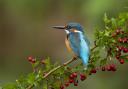
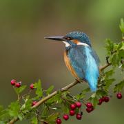
It’s also an excellent place for seabirds – a good site for gannets, which are one of my favourites. Stonechats perch on gorse and make the chinking sound for which they are named. The inland area is not without its treats, including jackdaws and, possibly, a kingfisher. The jewel in the crown for this area has to be the rare cirl buntings which are often found along the South West Coast Path hereabouts. Listen for singing males in spring and summer.
Walk: Options of varying length. The coastline offers wonderful panoramic views and circular walks can be made from the village of East Prawle or by parking nearer the coast for shorter options.
Map: OS Outdoor Leisure 20, South Devon, Brixham to Newton Ferrers 1:25 000
Parking: Around East Prawle village green (TQ7 2BY; Grid ref: SX780363); National Trust car park nearer the coast (Grid ref: SX774355)

Bowling Green Marsh, Topsham
This RSPB reserve is superb for bird watching at high tide, when the mudflats of the Exe Estuary are covered by water. At this point the wading birds relocate round the corner to feed on the marsh.
There is a very good hide with adjacent wildlife garden, plus a nearby viewing platform (access may be restricted due to COVID-19). Birds include vast numbers and varieties of waders and ducks: elegant little egrets, godwits, smew, widgeon etc. Sanderling and dunlin love it, as do peregrines who feed on the smaller visitors! Occasional red kites appear. Rarities I have seen here include glossy ibis, purple heron, spoonbill and long-billed dowitcher. Ospreys occasionally appear.
Walk: From the bustle of Topsham there is a pleasant half-mile stroll along Goat Walk, above the estuary, and then along a quiet road to the viewing points along the marsh. There is also a mile-long footpath/cyclepath from opposite Dart’s Farm.
Map: OS Explorer 114, Exeter & the Exe Valley, 1:25 000
Parking: various options in Topsham or at Dart’s Farm (EX3 0QH)

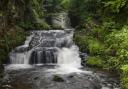
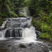
Watersmeet, Lynmouth
The deeply wooded gorge that leads from Lynmouth to the National Trust’s Watersmeet Tea Gardens is a superb start point for a walk, but in the summer of 1952 it was the scene of tragic devastation. After massive rainfall the rivers were unable to cope with the deluge and Lynmouth and its environs bore the full force of millions of tonnes of water and accompanying debris, resulting in the collapse of 39 buildings and the deaths of 34 people.
Today this fast-flowing and bouldery river is a magnet for dapper little dippers and grey wagtails. If you extend the walk beyond the gorge to reach the coast, there will be abundant sea birds.
Walk: The area is awash with footpaths for you to choose your route and distance – but the uphills can be strenuous. From Lynmouth follow the East Lyn River to Watersmeet. You could then head north to Countisbury for spectacular views as well as birds, then back along the coast path to Lynmouth (whole circuit about five miles).
Map: OS Outdoor Leisure 9, Exmoor 1:25 000
Parking: various options in Lynmouth.