
Wateringbury’s history stretches back to the pre-Christian Saxons. Nowadays you can walk along the delightful riverbank discovering the pleasures of the early spring wildflowers

Location: Wateringbury, ME18 5EA
Distance: 1.8 miles (3 km) Circular. Can be extended by another 2.9 miles (4.7km)
Time: Allow up to 1 hour or 2 hours with the extension.
OS Explorer Map: 148
Terrain: These paths can become very muddy. Two train line crossings. Four stiles that go through orchards. Also some gates.
Public Transport: There is a railway station at Wateringbury. For public transport directions to Wateringbury from your home address, please visit kentconnected.org
Parking: Parking is available at Wateringbury station – free for 2 hours
Refreshments & facilities: Where memories meet tea room/vintage centre at Wateringbury crossroads or the Railway Hotel
Discover a hidden walking paradise where druids once held sacred the yew trees in this area and hufflers who were men who hauled barges before horses took over, would labour for the equivalent of one pound per day! Wateringbury’s history stretches back to the pre-Christian Saxons. Nowadays you can walk along the delightful riverbank discovering the pleasures of the early spring wildflowers often sitting in tufts or even floating on the surface of the river. Stroll along at your leisure whilst admiring the glorious views of the Medway Valley. Give yourself a burst of life, by immersing yourself in the springtime glory of this walk.
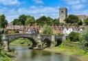
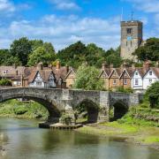
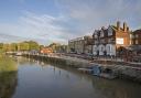
Wateringbury is an interesting but very apt name for this pretty village. The name is thought to derive from the Saxon word Wotringberia meaning a low and watery site. The Wateringbury stream flows into the River Medway just above Bow Bridge which you’ll shortly see in front of you. The stream was used to power several watermills as well as a brewery that was established here in 1820 later going on to blend whisky in the 1860’s.
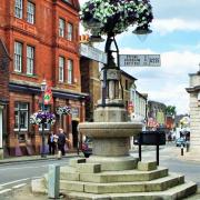
You’ll start the walk outside Wateringbury train station, regarded as one of the finest Tudor style stations in the country, so much so it was Grade II listed in 1985. Turn left out of the station and immediately left again to cross the train tracks and you’ll be beside the River Medway. With Bow Bridge in front of you turn right and take the lower path by the river.
Begin walking along the River Medway path with the river on your left. At the end of the moored boats the path enters and meanders through riverside trees. Continue along the path through the trees for about 1km.
As you walk along the River, spare a thought for hufflers who worked in this area pulling barges along the river Medway. Pulling a barge was a laborious job with hufflers often having to clamber over fences that would often stretch down to the water’s edge. It would take a huffler an entire day to pull a barge a distance of 8 miles from Maidstone to Yalding for which they would be paid a sum of one pound or 20 shillings in old money. One pound was worth around £45 in todays money, however the 1830’s was a time of great rural unrest with little or no job security and rising prices.
Horses began to replace hufflers in the 1830’s following the introduction of towpaths; however hufflers continued to work in this area right up to the 1880’s.
Continuing along the delightful riverbank, look out for the beautiful blue flash of the kingfisher which can often be spotted on the Medway. If you’re lucky you may spot an otter bobbing its head above the water. Otters have been increasing in numbers along the river and are particularly active in this spot.
After walking for about 10 minutes you’ll see a footpath on your right hand side. Take this path carefully crossing the railway line and follow the fence. You’ll see Nettlestead Place on your left hand side, a gorgeous Grade I listed country manor house with its own 14th century gatehouse set in beautiful and varied gardens. Nettlestead was mentioned in the Domesday Book of 1086. The Domesday Book of 1086 was commissioned by William the Conqueror King of England, to assess the extent of the land and resource ownership in England at the time and the extent of the taxes he could raise. It included the manor of Nettlestead Place, then owned by William the Conqueror’s half-brother Odo, the Earl of Kent and Bishop of Bayeux in Northern France and second in power after the King of England. Manors were typically noted as being very compact, centred around a church and separated by open land. Nettlestead Place appears to have been not unusual in this respect with the Saxon origin St Mary’s Church, immediately adjacent to it.
Continue straight on following the path past some impressive old yew trees and into the churchyard. The druids held sacred the yew tree as a symbol of death due to its ability to form new trunks and growth from old branches as well as the poisonous nature of the tree. The druid link to death has been linked to the location of yew trees in many churchyards during the present Christian times. Take a little look inside the church if you have the time, the 15th century stained glass windows are being particularly pretty.
Exit the churchyard, cross the road then turn right and walk along the pavement. Cross over Gibbs Hill and after approximately 25 metres the footpath on the left leads you away from the road so you walk between hedgerows with houses on your right hand side.
Continue straight on. Eventually through metal railings the path comes out among the houses. Turn immediately left between more metal railings and walk slightly uphill and on through the fields. This is the perfect opportunity to take in the glorious views of the Medway Valley. Early spring is such a good time to visit and watch spring beginning to unfold in front of you.
Approximately 50 metres before reaching a house you’ll see a footpath to your right which leads you down through a field. At the bottom of the field turn right and walk towards the houses. The footpath becomes the pavement beside the road again, turn left and follow the pavement for about 500 metres.
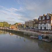
At the bend across the road you’ll see Wateringbury train station. You can finish your walk here, with a well-earned beverage in the neighbouring Railway Hotel.
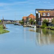
Alternatively you can continue along the riverside path with the river on your right hand side, past Bow Bridge Marina and towards Teston following the Teston River Walk. This beautiful riverside location will never fail to impress and it’s a perfect way to spend an easy afternoon. The gentle path meanders alongside the river providing a sense of peace and tranquillity.
Exploring Wateringbury makes for the perfect spring outing that is certain to relax and de-stress. Feeling the breeze through the freshly budding leaves and the first of the sun’s rays is certain to put that spring in your step.
Explore more
To find out about other walks in Kent including our literary walks, please visit the Explore Kent website www.explorekent.org. Follow @explorekent on Twitter and Facebook and share your experiences with us!