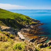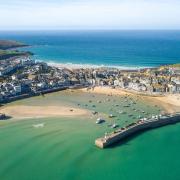

Beautiful villages, far reaching views and lots of history - Bodmin has plenty of great walks to suit all abilities

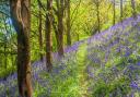
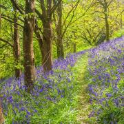
1. Blisland
Distance: 4 miles | Exertion: Moderate | Time: 2 hours 15 mins
Beginning at one of Bodmin Moor’s most attractive villages, noted for its historic church and award-winning inn, this pleasant circular route includes a mix of woodland, farmland and moor. En route are splendid views, a rock carved in honour of King George III and the still active De Lank Quarries.
1. Start from Blisland’s church, St Protus and St Hyacinth. Take the road up the side of the green, signed for Cassacawn and Pendrift. At the cross continue ahead up the lane past the village hall. At the next crossroads, continue ahead for Pendrift.
2. Cross a cattle grid, pass houses and go through a wooden gate. Follow the yellow waymarks. The path descends steeply, then winds across the valley floor to a footbridge. Cross the river and continue following the waymarked path, first left along the bank, then uphill. Pass a house and cross the quarry access road, going through a kissing gate. Now keep the fence on your right.
3. After 250m, turn right across a stile. The path winds up to a junction. Turn right, and you will soon see the quarry on your left. Pick your way along the upper edge of the quarry, then descend to the quarry car park, It is quite easy to miss your way here. Turn left (waymarked) past the settling tank. At the next waymark, take neither of the tracks, but instead look for a narrow footpath bearing left (north-east). This winds up the hill to a stile. Turn right along the path. Go through a small gate, then through a field gate and turn right, keeping the hedge on your right. At a cattle grid and ford, use the stepping stones to the right, and continue up the slope ahead until your reach an old field boundary. Turn right along it to find the Jubilee Rock, located at SX104744 amidst bracken and scrub - but massive enough to stand out.
4. Retrace your steps to the corner of the enclosed land, then turn right (roughly south) till you reach a lane. Turn left, then at the next junction turn right. Walk parallel with the road, on the common land to the right. When you reach a cattle grid, walk down the lane to a T-junction and turn right, back to the village.

2. Bodmin to Advent
Distance: 5.25 miles | Exertion: Easy | Time: 2 hours 45 mins
Far from the madding crowd, this gentle walk on the northern edge of Bodmin Moor gives fine views of its two highest tors and Cornwall’s highest points, Brown Willy and Roughtor. The route is accessible from Camelford by the Camelford Way to Advent (add 2.5m/4km) and forms a circuit across ancient fields separated by high hedge banks and winding lanes.
1. Start from Harpur’s Downs. Walk south-west across open ground to stile. Continue in the same direction across a series fields and stiles. Follow the path through a small wood to an old track. Turn right past Newton Farm. Continue to a lane.
2. 1 mile/1.4km Turn left. After 80m, the lane bends. Take the track straight ahead through a gate and a yard. Continue along the clearly defined track, a medieval ‘holloway’ up to and through the deserted hamlet of Carwether. The track continues downhill. Keep to the side where it is overgrown. Continue through a wooden gate and follow the track down to a barn. Keep right. Pass through Henon down to a clapper bridge over the River Camel.
3. 2 miles/3.2km Cross the bridge and the lane. Take the Public Footpath ahead through a gate. Keep the hedge on your right through two fields. Walk straight across the third field to a lane. Turn right to Tresinney. Turn right at the junction, then left 100m ahead to Advent Church.
4. 3 miles/4.6km Leave the churchyard by a stile at the east end, which indicates a division of paths. Do not turn right. Continue straight across the field. Follow waymarked stiles over five fields. eave the last field by a stile. Turn left up the lane.
5. 4 miles/6.3km Reaching Watergate, turn right and follow the lane south for ¾ mile (1.3km).
6. 4 ¾ miles/7.6km Turn left over a stile. Head through the glade ahead – another abandoned settlement. Descend the slope, keeping the hedge on your left. Cross the boggy area by stepping stones (partly obscured by trees). Follow the waymarked path to start.

3. Bodmin Moor
Distance: 4.5 miles | Exertion: Moderate | Time: 2 hours 30 mins
Bodmin Moor is a remarkably rich historic landscape and this discovery walk on East Moor has plenty of archaeological interest. Choose a really clear day to enjoy the wide moorland views and to locate the ancient monuments. This quiet quarter of the moor has few clear paths or bold landmarks, so map, compass and orientation skills are called for. GPS is helpful in locating the sites.
1. Start from East Moor Gate (SX222790), reached via a narrow lane two miles south of Altarnun. When parking, please don’t obstruct gateways, passing places or residents’ access. Go through the gate onto the open moor. Start by following the track ahead, and then head due south for ½ mile (1km) to the summit of a low, rounded hill. The most obvious archaeological features here are the ring cairn (SX224777) and the top end of the stone row.
2. Head due east from the summit cairn for 800m, keeping a lookout for a row of boundary markers. The first is at SX232777. Many have fallen, especially at the south-western end, so they are hard to spot. Turn left, north-east, along the row which leads to Nine Stones Circle at SX236781. Clitters Cairn, where flint and stone artefacts and coursed stone slabs were discovered during excavations, lies 500m east at SX242782. After visiting the cairn, head north to return to the line of boundary stones.
3. Otherwise, continue over the top of the ridge, following the line of boundary stones. When the bracken is low, you will see the remains of field walls and buildings, perhaps 3,500 years old. Continue in the same direction downhill. Aim approximately 100m to the left of the walled wood and you will find further remains of a substantial abandoned settlement.
4. While man-made climate change is a modern phenomenon, there have been significant historical fluctuations in climate, with major deteriorations around 1000BC (the late Bronze Age in Britain) and again around 1300AD. During both these periods many farms on the high ground were abandoned. Following the Black Death of 1348-9, when around a third of the British population perished, many of more farms on poor land were abandoned.
5. The clear routes through the bracken vary slightly from year to year, but head for the walled wood, then skirt its left side, down to a wall. Turn left and follow a path with the wall on your right. When the wall ends, continue down a rough track as waymarked.
6. After 250m, bear left on a track above a wood. (This track also serves as a watercourse!). After 40m, turn right over a stile into and through a wood. Emerging from the wood, turn sharp left to a stile, then right along the lane. After 100m, turn left over a stile (broken at the time of writing). Walk straight ahead for 300m as signed on a woodland path, which is often overgrown in summer. Ignore side turnings. Continue through a small glade. Cross a stile (again broken), then a stream. Climb up to Treburland Farm. Just beyond Treburland, a high stile in the wall on the right leads ahead over a field to a lane. Turn left up the lane, which continues as a track to a moor gate. Keep the wall on your right and make your way over tussocky ground to East Moor Gate.

4. Cardinham
Distance: 5.5 miles | Exertion: Moderate | Time: 2 hours 30 mins
This fairly easy walk through woods and fields in the green countryside west of Bodmin Moor has plenty of interest en route, including a historic church, an unusual mine chimney and a Norman castle. Pleasant through the seasons with wildflowers in spring and autumn colours, it offers shade on a hot day, but is well-sheltered against winter winds.
1. Starting from Cardinham Woods car park, cross the stream and pass to the left of the children’s play area. Turn right up the valley on ‘Lady Vale Walk’. At a major junction of tracks turn right and right again across the bridge (noting the clapper bridge alongside). Continue left up the valley (Wheal Glyn), At the next junction, ignore the Wheal Glyn turning.
2. Where the main track swings right above a mobile home, take the lesser track to the left. It becomes a lane. At a lane junction, turn left across the stream and follow the main track up, Turn right (yellow waymark) onto a path though a wood. Leave the wood by a stile and cross a field to a lane. Turn right, cross the stream and take the footpath on the right to the church.
3. Leaving the church, turn right along the lane for 400m to a steep hill sign. You now have a choice: take a short cut, continue along the road for a further kilometre (half mile), ignoring side turns, to the triangular road junction at point 5 and follow directions from there.
4. For the full route (including the remains of the Norman castle), take the bridle-way signed to the left, but be warned - the next part can be muddy! Go through the yard of the house, then cross a streamlet (not over the little wooden bridge) and walk down beside it. This is clearly a very old road leading across the valley to Castle Farm. Turn left here along the lane, and at the next bend you can just about see the fairly minimal remains of Cardinham’s motte and bailey castle. Continue up to a crossroads and turn right along the lane for 1km to a triangular road junction.
5. There are two tracks ahead. Take the one on the right (from the shortcut this is the first track on the right, just before the junction). When it forks, take the forestry track bearing right. Follow the main track, which at first winds downhill. Ignore the first turning up on the right. At a fork bear left, slightly uphill. Near the head of a steep valley, you will pass the engine house of Wheal Glyn. The track rounds the head of the valley, and then descends. Join the lower path and continue ahead to the car park.

5. Leskernick Hill to Bowithick
Distance: 5.5 miles | Exertion: Moderate | Time: 2 hours 30 mins
Choose a clear day for this walk over a wild and remote north-eastern corner of Bodmin Moor to enjoy the marvellous views and locate the antiquities. Good weather is also important for navigation on this route, which crosses open ground, with streams and wet areas. A map and compass are essential.
There is a lot to discover en route: stone cairns; the walls of a Bronze Age field system and settlement; a stone circle; a stone row and meandering mine workings. Of particular interest is the cist (stone coffin) on Buttern Hill, complete with its capstone.
1. Start from Bowthick’s bridge and ford. Walk south-west up the track to a gateway at the foot of a worked out tin stream.
2. After 800m, leave the track. Continue uphill with a tin stream on your right to the summit of Buttern Hill and its cairns, including one with a cist at SX175817.
3. From the summit, head south-east. On your right, between Buttern Hill and High Moor, is the source of the River Fowey. The river gave its name to this moor and Fowey Moor was renamed Bodmin Moor by the Ordnance Survey as recently as 1813. Beyond High Moor is Brown Willy. Continue downhill. A streamwork - a stream mined for tin and distinguished by its banks of overgrown rubble - comes into view. Make for the obvious crossing point in the streamworks at SX182810.
4. Cross the streamwork and head south and up Leskernick Hill past the cairn to the summit. Bear half right and downhill to explore the remains of the Bronze Age settlement and field system. Look carefully for lines of stones (field boundaries) and circles (round house foundations). Some of the round houses towards the south-east, where the dwellings are generally larger and perhaps from a different building phase, have annexes of porches. Walk south-east from the settlement to the prehistoric stone circle at SX188796. This is not easy to find as the stones are fallen.
5. Head north from the stone circle. Keep left of old mine workings. Cross the faint remains of a stone row. Climb gently to avoid the streamworks and a bog; then drop down to Point 4. Re-cross the streamwork and bear right. Continue along the valley with the stream on your right through mine workings and avoid wet ground. Keep left of the fence to reach Point 2. Retrace your steps down the track to the start.

6. Caradon and Minions
Distance: 7 miles | Exertion: Moderate | Time: 3 hours 30 mins
Discover Bodmin Moor’s ancient past and its recent industrial history on this fine figure of eight walk. During the Victorian copper boom 4,000 miners toiled around Caradon and Minions and the area was loud with the gasps and whistles of engines, the pounding of stamps and the shouts of men. Now silence punctuated with birdsongs predominates, but the Cornish miners have left many stark reminders of their tough and dangerous working life.
1. Take the track signed ‘Hurlers’ from the car park at southern end Minions. Reaching the Hurlers, follow the rough path north-east to Rillaton Barrow, a Bronze Age tomb that yielded a skeleton, dagger and golden cup.
2. Continue on the path, veering north-west to cross the sunken trackbed of Liskeard and Caradon Railway. Starting from Kilmar Tor, this carried ores and stone to Moorswater for onward transport to Looe Harbour. Continue to Gumb’s Cave, which lies near the western lip of the quarry, just below the Cheesewring. Hike carefully over boulders to the Cheesewring. Explore Stowe’s Hill and its two stone enclosures. Retrace your steps to the Cheesewring.
3. Continue past Gumb’s cave around the lip of the quarry to a track crossing. Turn left towards Caradon mast. Continue downhill to a stony track. Bear right onto the railway track with its stone sleepers. Follow it as it slopes gently downhill.
4. At the end of the track, bear right to Houseman’s Engine House, with its fascinating local historical and geological finds and displays. Continue west to the Hurlers. Retrace your steps to the start for the second (longer loop of this walk. Turn left out of the car park. Walk 100m along the road. Turn right onto a public footpath just before the Cheeswring Hotel - or stop for refreshment. Continue through a gate and along the stone sleepers of the old railway track. Continue past a wind turbine, through cuttings to a stile.
5. Cross the stile. Turn immediatley left down stone steps. Cross the small valley. Bear right to an engine house. Continue ahead on the same course to a track. Divert 100m right to Jope’s Shaft, with its engine house and chimney. Return to the track. Follow it east and uphill between ruined buildings. Continue east on a broad track past mine tips to the car park at Tokenbury Corner.
6. Turn left onto a track parallel to the road, then left and uphill towards (but not as far as) a house. Turn right past a mine tip. Join another former railway track. When it forks, take the upper track. Walk gently uphill for 2km. Continue past two engine houses and then along the embankment to a road. Turn left and follow the road to the start.

7. Kilmar and Trewortha Tors
Granite forms the setting and theme in this rugged landscape, which combines industrial history with legend. Standing bold against the sky, Kilmar Tor’s granite ridge shows characteristic horizontal and vertical weathering, induced by wind, rain and especially the freeze thaw action of ice.
1. Go through the gate and bear left on the grassy track, initially with the wall on your left. Continue ahead beyond the corner of the wall towards the ridge which extens left of Kilmar Tor. When the track divides, fork left. Reaching an old cart track, turn left. You will soon see the long ridge of Bearah Tor, with Sharp Tor beyond it. Pass through a disused quarry, then turn left and head for the least rocky part of the Bearah Ridge to enjoy the superb views.
2. Retrace your steps for 50m. Now had for the fat left of Kilmar Tor, passing its astonishing granite formations. After 750m you will notice the trackbed of the Kilmar Railway.
3. Join the trackbed, which runs round the end of the Kilmar ridge - but divert to see the view from its outpost. Northward are the roundhouses of the reconstructed Bronze Age village at Trewortha, built to help students better understand daily life on Bronze Age Bodmin Moor. Rejoin the trackbed, which soon peters out. Turn left down a fairly steep path. Make your way north to the nearest point on the metalled track leading to Trewortha.
4. Take a line at a tangent to the great sweeping curve of wall. Cross the track and follow the wall round past Treworth Tor and across some turf to King Arthur’s Bed. Retrace your steps as far as the corner of the stone wall. Continue walking ahead to reach the Trewortha track. Follow it east back to the start.

8. Altarnun
Distance: 6.5 miles | Exertion: Moderate | Time: 3 hours 15 mins
As well as fine views to Bodmin Moor, this walking route includes two historic bridges, 17th century Gimblett’s Mill and Laneast church. It begins and ends at Altarnun, one of Cornwall’s prettiest villages.
1. Turn left out of the churchyard opposite the 15th century packhorse bridge. Follow the lane uphill out of the village. Take the first tarred lane on your right. Continue 500m to a Y junction. Turn left and almost immediately right over a granite stile onto the second signed public footpath. Follow the direction markers ahead carefully via fields, a copse and stiles to a metalled lane. Take the signed public footpath to Higher Tregunnon Farm.
2. Just beyond the farmhouse, turn left at a public footpath sign on a barn post. Cross the field to a stile. Cross the next field and follow the steep path downhill to a lane. Turn right and follow the lane to the river Inny.
3. Continue to Laneast Church, Follow the lane for 100m to a sharp bend. Turn right at a footpath sign. Walk through the farmyard by gates and stiles. Cross the field ahead. Aim for bottom left corner of the next field. Cross the brook by a stone bridge and turn right. The path follows stiles and fields to a lane at Trespearne. Turn right downhill to Gimblett’s Mill.
4. Cross the bridge (1847). Continue for 100m. Turn left at the public footpath sign and cross a stile. Continue to another stile. Cut half diagonally right across a field to a further stile. Follow the direction arrows across the next field. Turn right up to a green lane. Follow it left to Trethinna.
5. Turn right onto the lane and left at the T-junction. After only 20m, turn right into a footpath. Continue 300m to a waymark just before Trerithick Farm. Turn sharp right to a field gate. The path continues over fields by gates and stiles. Follow the green lane into Trenarrett.
6. Turn left at Trenarrett and left 50m ahead onto a signed path at Little Trenarrett. Follow the path downhill to a bridge and uphill towards Oldhay. Skirt right of the farm and walk uphill to a field gate. Continue ahead, following marker arrows over fields to Tresmaine. Follow signs through the farmyard. Take the footpath signed ‘Altarnun’ across fields and stiles.