
Kevan Manwaring takes the Thames Path through the Cotswolds from Kemble to Wallingford - 77 miles of glorious countryside

Amble along the greatest river in England from its modest source near Kemble all the way to London (or as much as you fancy), and you’ll pass through lovely countryside steeped in history and literature, with plenty of riverside pubs to boot – what better way to idle away a summer day or a week or two?
Walking along a river bank is one of the most relaxing things you can do. One doesn’t really have to think about the route, merely follow the lazy curves as it meanders through meadows, flows through wooded vales, and slides past charming houses and riverside heritage. The scintillation of light on the glassy surface, the soothing pink noise of its constant movement, the sense of peace and timelessness, are all conducive to well-being and flashes of inspiration. It is small wonder that rivers have inspired poets and philosophers, painters and scientists, for centuries.
The River Thames, England’s greatest river (its sister, the Severn, wins the accolade of the longest in Britain), is the spine of our nation’s history, and has played witness and agent to its pivotal moments, from the arrival of early man, hunting and gathering along its banks; the Beaker People and barrow-builders; the waves of invaders, settlers, tribes and armies, legions and rebellions, civil wars and royal splendour. From Tudor navies to the Industrial Revolution, Cotswold wool-towns to Canary Wharf, TS Eliot’s ‘strong, brown god’ has seen it all, although the ‘charter’d Thames’ of Blake’s ‘London’ begins in a sleepy meadow in Gloucestershire as a barely visible trickle.
The riparian pleasure of the Thames Path, a national trail that runs for 184 miles (294km) from its source to the Thames Barrier, is that you can follow its remarkable journey, and by default, the story of a nation, all the way through nine counties (Gloucestershire, Wiltshire, Oxfordshire, Berkshire, Buckinghamshire, Surrey, Metropolitan County of Greater London, aka Middlesex, Essex and Kent) to the North Sea if one wishes. The walking is, on the whole, easy and level (although be prepared for muddy and even flooded sections after heavy rains); there are no shortage of fine hostelries, facilities, places to stay, eat and recharge along the way.

The Thames Path is well-signed and maintained and mostly clings to the banks for its entire length (the section between Upper Inglesham and Lechlade has finally been opened, so road walking is no longer required there). One can undertake the Thames Path in stages – day-walks; weekend walks – or do it all in one go (15 days is the minimum, though 18-20 is recommended with rest/exploring days).
Geologically, the Thames Path can be divided into three sections – Upper Thames (source to Goring Gap), Middle Thames (between Goring and Teddington) and Lower Thames (London and beyond). Only the first section need concern us here (the main section covered from the Cotswolds to the Chilterns), but of course the rest await those determined to do the full stretch! The key thing to remember is – it’s not a competition, and nobody is going to check how much you’ve done. If you want to skip a bit, or do some of it by boat, cycle, bus or rail, that’s completely fine. The whole point of river-walking is the lack of stress. Take it easy, stop for a drink and a bite to eat at a pleasant pub; or simply gaze at the slow grace of the river, its waterfowl, wildlife and corridors of biodiversity, and for a little while forget all the cares of the world.

The Walk (Source to Wallingford 77.1 miles)
1. Source to Cricklade - 12.3 miles (19.7 km)
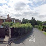
The source of the mighty river Thames is marked by an engraved stone and the signpost for the Thames Path. Apart from that there isn’t much to see for a few fields, especially in the summer. You may want to wet the infant river’s head at the Thames Head Inn, to gird your loins for the long walk ahead (or to celebrate making it to the end, if you started at the other end). The river eventually makes it shy debut and is glitteringly clear and lush with wavering vegetation. This section passes through some charming Cotswold villages, photogenic in their honey-coloured stone in love with sunlight. The Path pushes on to pass through the Cotswold Water Park, with its 140 lakes created through (mostly) gravel extraction – important havens for a wide spectrum of wildlife, of the winged, webbed, scaled, furred, and Goretexed variety. Keep your eyes peeled as you pass the North Meadow national nature reserve (home of the rare snakeshead fritillary flower), before arriving at the Saxon town of Cricklade, head of navigation for the river.

2. Cricklade to Lechlade - 11 miles (17.5 km)
From here the Thames Path starts to follow what starts to look like a river, albeit a youthful one, wending its way among the peaceful fields, a million miles it seems to the heart of the capital. A recommended refuelling opportunity can be found at Castle Eaton, in The Red Lion, a popular village pub (booking essential in the busy summer months). The 12th Century church is also worth checking out. From here the path now continues to follow the river thanks to a recent reroute (previously you had to negotiate a busy A road). Just stay on this all the way to Lechlade. You’ll start to see you first boats on the Thames. At Inglesham do check out the ancient church of St John the Baptist, restored by the 19th century poet and craftsman, William Morris. We’ll be meeting him again downstream. Here, also the River Coln joins the Thames, and the Thames and Severn Canal leaves it (last used by Stroud-bound coal-barges in 1927, although plans are well under way to restore it).
[The Round House here was the unusual quarters of the lock-keeper - horses were stabled on the ground floor with people living above.]
Finally, you’ll reach the wool-town of Lechlade, crossing at the picturesque Ha’penny Bridge (now toll free since bolshy residents protested in 1839). The Riverside Inn is a good place to recharge your batteries, or the tea-rooms opposite.

3. Lechlade to Newbridge - 16.4 miles (26.2 km)
The longest, most peaceful and remote section of the Thames Path, this follows the maturing river as it wends its way through the flood plain of the Thames Valley. At St John’s Lock (the first on the river) you’ll find Old Father Thames himself (relocated from the source after vandalism). Worth making a libation (eg a pint) before pushing on through mixed farmlands. After Tadpole Bridge the Thames Path runs through Chimney Meadows National Nature Reserve, a large area of wildlife rich meadows managed by the local Wildlife Trust. At Radcot you pass the oldest bridge on the Thames, and can idle the miles away with bridge-spotting (Old Man’s bridge; Tenfoot bridge; and the 13th Century ‘Newbridge’). Of the 45 locks on the non-tidal Thames, 6 can be ‘bagged’ along this stretch. You won’t encounter many villages on this section, but fear not, intrepid riparist, for the odd tavern awaits at the occasional road-crossing; and at Newbridge – you’re spoilt for choice.
4. Newbridge to Oxford - 14 miles (22.4 km)
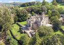
By Newbridge the Thames is all grown up and supports a flotilla of boats. Even as it approaches the heart of Oxford it remains delightfully rural and ‘far from the madding crowd’. The Path leaves the river for a couple of miles at Bablock Hythe, a former ferry crossing (until a footbridge will be constructed to allow walkers to continue on the old towpath on the opposite bank). Further downstream, Swinford Bridge (1770) is one of only two remaining toll bridges on the Thames – free to pedestrians wanting to visit Eynsham. From The Trout at Godstow, opposite the ruins of the Abbey, you enter a truly lovely stretch that runs by the wide expanse of Port Meadow along banks saturated in history and literature: Fair Rosamund, mistress of Henry II...Alice in Wonderland...Binsey Poplar...and most recently, Philip Pullman’s La Belle Sauvage (see my ‘Dreaming Spires and Rabbit Holes’ walk, Cotswold Life July 2017). The delights of Oxford await!
5. Oxford to Abingdon - 9.9 miles (15.8 km)
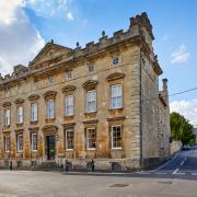
This shorter stretch enables a half day exploring Oxford. Leaving south of the city, the Thames Path heads towards Abingdon along a lush, green riverscape. A few pleasant miles downriver, at Sandford, the lock there has the greatest fall of water on the Thames with its weir, known as the Sandford Lasher – who sounds like a rogueish villain from a romantic novel! Crossing the Thames at Abingdon Lock you arrive at the southern end of Abingdon Bridge with the town to the north, one of the most important on the Thames, boasting a magnificent town hall and abbey (founded 675AD).
6. Abingdon to Wallingford - 13.5 miles (21.6 km)
This section passes the distinctive landmark known as Wittenham Clumps, aka the Sinodun Hills, aka The Bubs, aka (my favourite) Mother Dunch’s Buttocks. I offer my version of the local folktale, The Raven of Sinodun Hill, in Oxfordshire Folk Tales. The hills were immortalized by Paul Nash, who painted them obsessively after falling in love with the ‘beautiful, legendary country’ of South Oxfordshire. The river takes a sharp bend south of Abingdon, between Culham and Wittenham, adding an extra 5 miles, just for the fun of it. The day is book-ended by two handsome abbeys – at Abingdon and Dorchester, the latter built around 1140. Here, at Dorchester-on-Thame, the river Thame joins the main river, and strictly speaking, becomes the Thames in earnest. The Upper Thames is traditionally known as the Isis – many maps still mention it – but I could hardly call this walk ‘taking the Isis Way’ as folk might get the wrong idea these days! Still, it is interesting to note that the old Celtic name for the river was Tamesa or Tamesis (either ‘darkly flowing one’, or ‘wide, flowing’), the Romans recorded this as Thamesis, and the Saxons, Temes or Temese. Whatever name we call it, the river flows on. For those with the stamina, another 100-odd miles await, all the way to the sea!
The essentials:
Distance: 184 miles (294km) with minor variations depending on route options.
Level: Easy walking – mainly level. Can be muddy or flooded.
Maps: Harvey XT40; or Cicerone Thames Path Map Booklet.
Dog-friendly: yes
Pubs: Take your pick!
Transport links: Nearest train-station to starting point: Kemble; or bus-links to Cirencester. Various bus services along the way connecting to nearest towns or cities (Swindon; Reading; London).
Highlights:
1. Idyllic backwaters: peaceful scenes and sleepy villages. [Snake’s Head Fritillary]
2. Charming towns: the little gems of the Thames Path [see Day 2:Lechlade].
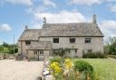
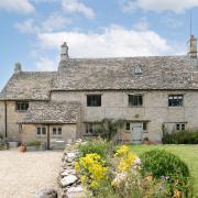
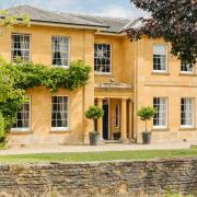
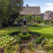
3. Kelmscott: 17th Century Grade 1 listed manor house; former home of William; Pre-Raphaelite Collection; tea-rooms and gardens.
4. St John’s Lock: Old Father Thames [drawing]
5. Runnymede: History in the Making (the Magna Carta was signed here in 1215)
6. Windsor Great Park: Royal-spotting, Herne’s Oak, and Merry Wives.
7. Hampton Court Palace: Courtly splendour and gorgeous gardens.
8. Blake’s London: ‘where the chartered Thames does flow...’
9. Tower Bridge: the throbbing heart of the capital.
10. Thames Barrier: engineering marvels and estuarine delights.