
Simone Stanbrook-Byrne discovers wildlife-rich waters, an old railway line and Victorian splendour at the foot of the Mendips

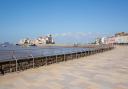
The first time I saw Cheddar Reservoir was from the top of Cheddar Gorge. To the west was a startlingly circular lake looking very man-made. Which, of course, it is.
Opened in 1937, its water supply comes from the river that runs through Cheddar Gorge, but despite its concrete sides it is a magnet for birdlife. During the raw months of the year coots, great crested grebes, tufted ducks and pochards may all be spotted. Little owls are resident all year round.
The reservoir has an area of about 260 acres and its peripheral path makes for easy walking. Add in a stroll up to the woods of a Somerset Wildlife Trust nature reserve and you have the makings of an enjoyable amble. Don’t forget binoculars!
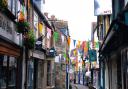
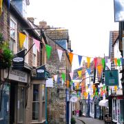
It’s also worth noting that Axbridge Farmers’ Market takes place on the first Saturday of every month – a good time to visit.
1. From the long car park beneath the reservoir embankment, return to the gateway that gives access up to the reservoir. Turn away from this and walk along the tree-flanked approach drive that you have just driven down; there are views ahead up to the tree-clad slopes of Cheddar Wood.
At the end of the drive cross straight over (watch for traffic) and take the signed footpath opposite, along Wood Lane. In 100m you reach a busy road, cross this with even more caution and then continue ahead up the yellow-arrowed rising track signed for Shipham.
Keep going through a gateway and after this look out for arresting views to the right, towards St Michael’s, a magnificent residential home for physically disabled adults. This remarkable Victorian Gothic house was built in 1878 as a private sanatorium, founded by Matilda Gibbs who built it in memory of her husband, William, and three of their seven children who died of tuberculosis. Something architecturally beautiful and philanthropic arising from tragedy.
Keep going, the sound of the road diminishes and the path passes a small ruined building on the left.
2. Just over 200m from the road the track passes through another gate and swings left. To the right here are yew trees in an enclosed area and ‘cemetery’ is marked on the map. In the late 19th century this area was set aside as a burial site for deceased patients at St Michael’s. Men were buried on the south side, women on the north; the headstones were moved to the side of the cemetery in early 21st century.
Follow the track as it goes left, still following yellow arrows. In about 50m cross a stile and turn right, following the track uphill beneath trees. To your right, beyond the trees, is an open field. Depending on the time of day and year, this woodland may be full of birdsong.
3. Follow the track for 250m and just after the field over to the right ends, look for a wooden footpath gate on the right. Go through this, now walking along the top of the same field but fenced from it, with good views towards the reservoir on the right through rather splendid trees. Another field slopes up to the left. Depending on the time of year this path can be lush with wildflowers; in spring the wild garlic is fragrant and bright with white flowers.
The path passes a corrugated iron hut. Keep going, this is delightful woodland walking. Pass through an arrowed wooden kissing gate by another corrugated iron building and stay with the broad track as it now starts to descend more quickly.
The track passes an access gate on the left into Cheddar Wood Edge Nature Reserve, one of the Somerset Wildlife Trust sites. If you wish to explore you can, but come back to this point and continue downhill.
The track drops to the road, passing the back of The Parsonage, formerly a ‘grace-and-favour’ house for St Michael’s resident chaplain but now in private ownership.
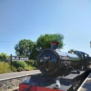
4. At the main road turn right, following the pavement and crossing over when it is safe to do so. In less than 200m, near the road junction, an obvious fingerpost directs left along the Strawberry Line. Take this; as well as a footpath it is also part of the National Cycle Network, Sustrans Route 26 – watch out for bikes!
The Strawberry Line is a great stretch of walking. Originally part of the railway between Yatton and Axbridge, the line was dismantled and in 1978 the Cheddar Valley Railway Walk Society (now the Strawberry Line Society) persuaded North Somerset Council to buy much of the dismantled line and to then lease it to the society as a footpath and nature reserve.
Follow the gently descending path, there are views across the reservoir to the right and picnic benches are abundant. Keep going, the back of the yacht club comes into view on the right; wood-clad hillsides of the Mendips are way over to the left. As you continue, far to the left, you may spot the cleft of Cheddar Gorge. When we did this walk in the summer, towards the end of this section there was evidence of earthworks to the left of the path as a new water main was under construction.
5. Just over 1km along the Strawberry Line look out for an information board stating ‘You Are Here’ at Holwell Lane. (If you reach the entrance to Sharpham Road Playing Fields you’ve gone too far, go back 20 paces!) At this point the Strawberry Line ahead has been temporarily diverted, but even if it has reopened this walk turns right here (in the opposite direction to the signed village centre).
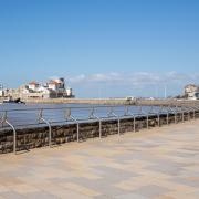
Follow the stony track, a public footpath, ignoring the narrower footpath going right within 100m. Keep straight ahead to reach the ramp leading up to the reservoir. Turn right along the surfaced path, water to your left, a pleasant and easy end to the walk and a chance to watch boats and birds. Despite the clear signs forbidding any unauthorised swimming we found a crow enjoying a delicious wash-and-brush-up.
As the path approaches the yacht club admire the views to the right towards the Mendips. There are good views all around.
Keep going beyond the yacht club for 450m, at which point you reach a broad surfaced track heading right, down to gates. Go down here and you are back at the car park.
Simone Stanbrook-Byrne is the author, with James Clancy, of ‘A Dozen Dramatic Walks in Somerset’ and other walking guides for the West Country.
Compass points:
Start point and parking: Cheddar Reservoir is on the edge of Axbridge, on the A371. This walk starts from the parking area at the north side of the reservoir, accessed off Cheddar Road in Axbridge where a small road sign directs to the reservoir. Nearby postcode: BS26 2DL. Grid ref: ST439543
Public transport: Buses run between Axbridge and Cheddar, see travelinesw.com
Map: OS Explorer 141 Cheddar Gorge and Mendip Hills West 1:25 000
Terrain: Tracks and woodland paths; the Strawberry Line plus the peripheral path around reservoir. Note – there are busy roads to cross
Distance: 2.5 miles/4km. This can be increased by exploring the nature reserve and walking more of the reservoir’s peripheral path
Dog friendliness: Yes, but animals grazing and busy roads to cross
Exertion: Moderate, expect some incline during the first half of the walk
Facilities and refreshments: None en route but plenty of picnic benches along the Strawberry Line. Many options in nearby Axbridge and Cheddar