

Dating from around 2,500 years ago, in the Iron Age, cliff castles and hill forts occupy some of the most dramatic spots in the county, writes photographer David Chapman.

What are hill forts?
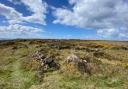
There are a surprising number of hill forts in Cornwall, probably more than 80. Since they have their origins in the Iron Age there is little left for us to see except a circle of substantial stones or a series of banks and ditches. Some of them were built around quoits and barrows showing that they had a spiritual significance to the people as far back as the Bronze Age. Over time these locations were ‘fortified’ with ditches, ramparts and maybe wooden palisades and inside would have been round houses for people to live in. Although we refer to them as ‘forts’ the ramparts would likely have signified ownership of a property. Who knows if they were ever put to test in a combative sense.

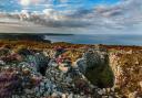
In the Iron Age promontory forts served essentially the same purpose as hill forts but their construction would have been easier since they required only a relatively short straight rampart and ditch to traverse the narrow neck of a headland. The main difference seems to be that promontory forts were less frequently occupied. This might be because they were in quite exposed spots so were not particularly well suited to habitation, though there is evidence to suggest that our climate during that period was more benign.

Whether or not they were good for habitation, promontory forts were built in very dramatic places which has led to historians wondering whether they had religious significance. It is quite likely that many such historic places were built on previously existing sites and it seems conceivable that those were spiritual. There is also a consensus that promontory forts, being easily defendable, would have been used for trading valuable commodities such as tin and copper.

Hill forts continued to be occupied into and even after the Roman era but promontory forts ceased to be of real significance, simply falling into disrepair. Maybe the changing climate made promontory forts less attractive, it would be hard to imagine maintaining a property for doing any sort of business on a Cornish headland in our current climate.

Where to find them
Promontory forts can be found at a huge number of locations around the coast of Cornwall and the Isles of Scilly. Any headland with a narrow neck is a suitable candidate. It’s great fun to find your own and become an archaeological detective. When out for a walk along the coast path just look for a straight bank across the narrowest part of a headland.

Hill forts tend to be slightly more difficult to find because many are on private land and their embankments have been more impacted by our use of the land in more recent times.

As detectives we should use Ordnance Survey maps which show embankments with a line or circle of small wedge-shaped marks. On any maps or even when out and about we should be looking for clues in the names of places. The obvious terms ‘castle’, ‘castell’ or ‘fort’ which are sometimes found in italics on maps are a give-away. But also look for the words ‘dinas’ (Cornish for castle); ‘car’ or ‘caer’ (often used for circular fortresses in Cornish) and ‘burh’ or ‘bury’ (a term for a fortified place) all of which can be found in many place names. So, it is safe to assume that Cardinham, Caerloggas and Caerhayes had ancient forts as well as the more obvious Castle-an-Dinas of which we have at least two.

Some of the best from around the county are:
Hill forts: Caer Bran (near Sancreed); Chûn Castle (near Morvah); Trencrom Hill (near Carbis Bay); Castle-an-Dinas (near St Columb Major); Cadson Bury (near Callington); Warbstow Bury (north of Bodmin Moor near Camelford).
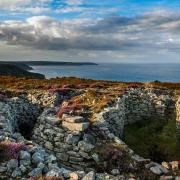
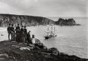
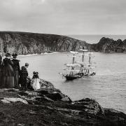
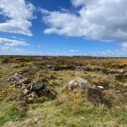
 and to the left, Maen Castle an Iron Age promontory fort")
Promontory forts:
Maen Castle (on the coast path between Land’s End and Sennen); Treryn Dinas (Logan Rock, near Porthcurno); Gurnard’s Head, also named Trereen Dinas (near Zennor); Lankidden and Chynhalls headlands (near Coverack); Roundwood Fort (near Trelissick is an interesting one because it is on a creek); Trevelgue (at Porth Island, near Newquay); The Rumps (near Polzeath); Rame Head.

On the Isles of Scilly we have a couple of great promontory forts: Giant’s Castle on the coast of St Mary’s near the airfield and Shipman Head at the north end of Bryher.

David’s photography tips
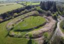
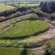
Hill forts are difficult to photograph because they are on the summits of hills. It is usually only possible to show a section of their embankment and ditch system from ground level. It is vital to take photos when the sun is low in the sky, this shows the contours with light and shade. I also recommend getting the camera as high as possible, so I sometimes hoist it above my head on top of a fully extended tripod or monopod. A drone would be ideal.

Promontory forts are a little easier because they occur in extremely photogenic locations. My best photos tend to focus primarily on the scenery showing the remains of the forts as part of a distant landscape. Alternatively, it is sometimes possible to stand close to the embankments and use them as foreground in the scenery, in which case a very wide-angle lens is usually required. As with hill forts it is best to take photos early or late in the day when the sun is low in the sky.

To see more of David’s photography visit his website at www.davidchapman.org.uk or look out for his book Photographing Cornwall available in all local bookshops.