
Explore a stretch of the new Tamara Coast to Coast Way in the lush Tamar Valley
Rising on Woolley Moor near Bude, the River Tamar forms the historic boundary between all but three miles of Devon and Cornwall, flowing 61 miles from source to sea at Plymouth. It’s a beautiful part of the Duchy – lush and tranquil, far from the madding crowds of the honeypot destinations.
It’s also good walking country, although not everyone knows it. This could be about to change with the recent launch of the Tamar Coast to Coast Way, a new 87-mile walking route stretching between north and south. Designed to be completed in seven days, it begins at Cremyll, overlooking Plymouth Sound, and finishes at Marsland Mouth, the little cove near Morwenstow that marks the start of the border.

In between are the unspoilt valley landscapes that have earned this area prestigious designations - the Tamar Valley Area of Outstanding Natural Beauty (AONB) and the Cornwall and West Devon Mining Landscape World Heritage Site (Unesco) – as well as centuries-old churches, quaint cottages and traditional inns aplenty.
Linking the two coasts has also achieved the long-held ambition of creating a circular walking route linking both ends of the South West Coast Path in Cornwall in a 387-mile loop. Its name: Kylgh Kernow, Cornish for Circuit of Cornwall.
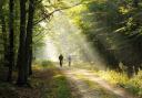
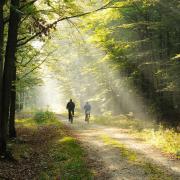
Many shorter walks have developed along the route, and we opted for one of these. Gunnislake and Calstock are both on the stunning Tamar Valley branch line, which starts in Plymouth and is particularly breathtaking as it passes under the Tamar Bridges and follows the sweep of the river at its widest point. The walk between the two stations is the perfect length to make the train at Calstock, and even have a cake and a cuppa before you board.

You’ll get a flavour of both sides of the Tamar Valley here. The first Tamar road crossing after Saltash, Gunnislake New Bridge isn’t as new as its name suggests – it was the site of a 17th century battle during the English Civil War. Today, Gunnislake still has the air of a hardworking settlement, the kind that would once have studded the area in its industrial heyday. Over 7,000 people were employed in the Tamar Valley mines in 1862, while market gardening thrived thanks to the mild and early climate and advances in transport.
In contrast, Calstock is as pretty a village as they come in Cornwall, with galleries, tea shops and a jaw-dropping railway viaduct, and I chose to end rather than start the walk here to enjoy the views of this fabulous feat of engineering.
In fact, the walk was very easy to follow (even backwards), as the route is clearly signed with green arrows on a blue background, either as Tamara: Coast to Coast or Tamar Valley Discovery Trail. It’s a bit of a sandwich, starting and ending on the riverbank with country lanes in between.

The land closest to Calstock was recently returned to wetland, and the Tamar Community Trust is working in collaboration with the Environment Agency on a £2.2million flood defence scheme, including timber boardwalks across the most vulnerable stretches of riverbank. Next spring, a two-year trial is planned to resume the passenger ferry from Calstock pontoon to Ferry Farm on the Devon side.
When you alight at Gunnislake station, consider diverting left up the hill to the Tamar Valley Centre (open Tuesdays and Thursdays - please call ahead on 01822 835030). There, you can buy a guidebook, seek advice from the friendly team and learn how painter JMW Turner immortalised the landscapes you’re about to see.
Alternatively, for more information about the Tamara Coast to Coast Way, Kylgh Kernow and shorter walks, and to purchase a guidebook, visit tamarvalley.org.uk

The walk
1. Turn right out of Gunnislake station onto the main road, and immediately right into Wellpark Road, then left down tree-lined Stony Lane.
2. At the bottom of the hill, turn left at the T-junction. Pass the Rising Sun Inn on your left, then turn right down Kingswood Road and again right down Bealswood Road.
3. Upon reaching King George’s playing field, pass through the gate, walk down the right-hand edge of the field, and turn left along the far edge, keeping your eyes peeled for the steps on your right that will take you down to the riverbank. Turn right to begin the walk. (Alternatively, turn left and walk for 10 minutes to see Gunnislake New Bridge, then retrace your steps).
4. Follow the riverbank. Here, the Tamar is gorge-like, overlooked by the huge rocky outcrops on the Devon side. At Gunnislake Weir, originally built by the abbots of Tavistock as a fish weir, keep straight on.
5. When you reach the end of Bealswood Road, turn left past a row of cottages to pick up the river path again.
6. Upon reaching a sign informing you that the footpath ahead is a no-through-way, turn right and climb to reach a lane. Turn left and keep straight on this lane, ignoring all crossroads.
7. Upon reaching a T junction, turn left – in the direction of Calstock church. Pass under the railway bridge, then turn left again towards the church, which has benches and a toilet. This elevated position was once the site of a Roman fort large enough for 500 soldiers – there’s a most informative board opposite the church.
8. Keeping the church on your left, follow the road sharply downhill and cross the railway line.
9. Turn left, and at a group of houses turn right through a gate into Okeltor Wildlife Reserve. Okel Tor Mine once employed 200 people in the extraction of copper, arsenic and tin: it’s now a scheduled monument.
10. Exit the wildlife reserve at Okel Tor boathouse and turn left down a footpath which turns into a good riverside track. Enjoy the calls and splash of landing birds as the viaduct hoves into view.
11. Upon reaching Calstock, climb Commercial Road, looking out for a signed footpath on your right leading to the railway station.

Compass points
Distance: 4.5 miles
Time: 2 hours
Terrain: Easy underfoot, a couple of climbs
Map: OS Landranger 201 Plymouth & Launceston
Start: Gunnislake railway station
Finish: Calstock railway station
Public toilets: Tamar Valley Centre, Gunnislake (Tuesday/Thursday, by prior arrangement); Calstock Church, Calstock village.
Refreshments: Pubs and cafes at Calstock