A habitat rarer than rainforest is the setting for this 6k nature reserve ramble

In the heart of East Devon lies an oasis rarer than rainforest. The southern lowland heath of adjacent Aylesbeare and Harpford Commons has developed over millennia, with associated wildlife adapting to thrive on it.
It covers more than 200 hectares and is part of the East Devon Pebblebeds Heath SSSI – a special place indeed as it is Europe’s largest and oldest pebblebed heath and more than 200 million years old.
For those seeking wildlife it is heavenly, rich with dragonflies and damselflies, butterflies and birds – the rare Dartford Warbler may be found here. Ponies and cattle occasionally conservation-graze the habitat. For those seeking solitude, this open access land is crisscrossed with paths that can be explored ad libitum.

The walk follows waymarked public paths, and is a good base route from which to further explore.
Start point & parking: Car park for Aylesbeare Common Nature Reserve: Grid ref SY057897; no postcode, Directions to start: The car park is just off the A3052, a shade over ½ mile south east of the Halfway Inn (EX5 2JP), marked clearly on OS map. Turn right (south) off the A3052 and there is an awkward left turn into car park. Public transport: Buses run along the main road (see travelinesw.com) Map: OS Explorers 115 Exmouth & Sidmouth 1:25 000

Terrain: Heathland and woodland tracks and paths, some surfaced; the walk crosses the busy A3052, so care needed there
Distance: 3.75 miles (6km)
Dog friendliness: Take a lead as lots of wildlife and the possibility of grazing animals, so dogs will need to be kept under control. The walk briefly touches the busy A3052

Exertion: Easy
Refreshment: None en route but nearby is the Halfway Inn, EX5 2JP (01395 232273). Also various options in Newton Poppleford

Route:
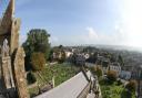
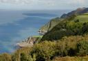
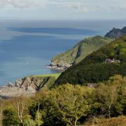
1 From the car park, walk back to the junction with the A3052, crossing with care and bearing diagonally left to join the surfaced access track onto Aylesbeare Common. A fingerpost shows this is the East Devon Way (EDW) towards Sidbury, denoted throughout by fetching pink foxgloves and arrows. It is also the drive to Woolcombes Farm. The track passes an information board and drops gently downhill. Expansive views are all around; away to the right is the Sidmouth Gap and further right you may glimpse sunlight glinting off the distant sea.
The track passes a gas pipeline marker and bends right about 200m from the start. There are frequent, un-waymarked paths leading off the main walk route; if you explore you will need to navigate back to the path. (Off to the left of this main path is an area of ponds, good for dragonflies.)
2 In another 500m the way reaches a yellow-arrowed post. You can leave the tarmac here, turning right along a track used by horses that runs parallel to the surfaced path, which is still visible through the scrub to the left. Stay on the obvious track until it veers left in under 200m (where a narrower path continues ahead), and rejoin the tarmac path by a cattle grid. Cross this and continue along the tree-flanked tarmac, still following the EDW.
In just over 100m, where the surfaced track swings left, the EDW continues ahead through a gate. Stay with the EDW, following the track beyond the gate; Woolcombes Farm is visible to the left. The rough track descends through woodland and bends about, reaching a stream in about 250m where a footbridge carries you drily across. Bear left after it and rejoin the EDW, still in the same direction and now climbing.
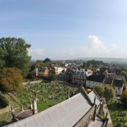
Look out for occasional ‘popples’ underfoot. These pleasingly rounded stones have their origins in the aforementioned pebblebeds, ancient layers of pebbles, lying below the heathland, that were formed during the Triassic era. The pebbles came from a desert region through which a mighty river flowed, carrying the stones along. This tumbling, and subsequent weathering, moulded the popples into their smooth shapeliness, and from them Newton Poppleford derives its name.
When the woodland on the left ends, pastoral farmland appears through the trees. Keep going on this appealing path round the margins of the common until you reach a wooden gate with a fingerpost beyond.
3 Pass through the gate and turn right along the broad track, still the EDW. Just past a house on the left you are confronted by large wooden gates. Swing right here and follow the path out onto the more open common. Follow the most obvious broad track as it goes ahead then bears left. Over to the left is a wooden garden fence.
The track passes some metal livestock paraphernalia over on the left, then bends right and just after this is a diminutive arrowed post at a fork in the path. Keep right here, along the broad, stony EDW, soon passing another arrowed and foxgloved post to the right of the path. Glowing gorse lights the way. “When gorse is out of flower, kissing is out of season,” goes the old adage, but wherever you find gorse you will find some in flower, so take lip balm. I met an elderly man along here, clearly relishing the moment and his walk.“It’s a beautiful morning and it’s lovely being here!” he said.
Read more: A healthy, happy walk at Silverton.
4 The EDW continues with more open heath to either side. It widens into a clearing about 400m from the earlier fork, then continues ahead, ducking beneath trees. Keep ahead, a pink arrow directs and some lovely old trees preside over the path. Birdsong cascades through the woodland. Within 200m you reach another fingerpost. Turn right, leaving the EDW and joining a yellow-arrowed footpath. This reaches another fingerpost within 50m; turn right again, cross a cattle grid and follow the path along the lower edge of Harpford Common. Burrow and Newton Popp are visible to the left. The way becomes more wooded with glimpses into fields and paddocks on the left, and you pass the entrance to Outer Hanger. Enticing, un-waymarked paths head right onto the common; as before, if you explore, come back. The path follows the periphery of the common, keeping its southern boundary to the left. The path descends and bends, dropping to another footbridge over a stream. Keep going after this and in about 120m you reach an arrowed fence corner on the left.
5 Go left round the corner as directed by the arrow, then veer very slightly right to join a path that runs parallel to the left-hand fence, about 10m away from it and slightly higher. This path reaches a fingerpost in less than 100m. At the post turn right, climbing up through woodland, over tree-root steps, to reach a grassy path. Follow this, with scrubby heathland to the right and trees to the left with fields beyond them. Keep going as the way narrows between brambly scrub. The path is obvious, well-trodden and continues through trees. Pass a yellow-arrowed post and continue. This is one of life’s pleasing paths: autumn colour can be lovely, depending on the prevailing conditions of the year, and in spring the woodland is deeply bluebelled. Meander through the trees: Harpford Hill begins to rise to the right and the perimeter fence stays with you a little way over to the left.
6 The path climbs and a stream appears down to the left as you walk, briefly, deeper through the wood. After a short, steepish rise to a stretch of wooden fence with a small chasm on the left, bear left with the path to cross a footbridge. Follow the well-trodden path beyond to a low, arrowed post within 100m and from here head left to the arrowed gate a few metres away. Go through and head down the track beneath majestic beeches to reach the A3052 near a bend.
7 CARE here please! Cross the road and turn right for 50m, keeping as close to the verge as you can, it may be busy. At the fingerpost go left through a gate and find a multiple-arrowed post beside a crossing track. Ignore paths to left and right and join the footpath that leads ahead, away from the road. Follow this clear path as it winds about with occasional yellow arrows to reassure. Ignore any unsigned paths off. The path bends sharp right in 180m, followed by a left. After this, at an arrowed post, ignore a left fork and stay on the climbing path, crossing an unmarked track and arriving at a junction with a blue-arrowed bridleway in 100m.
8 Turn right, following the rising bridleway. Keep ahead at a crossing path, and also when another track joins from the right. In 50m the path forks – the choice is yours as both paths converge a little further on. Keep going and you arrive at an information board just outside the car park from which you started.
Ordnance Survey maps are available from all good booksellers and outdoor stores or from the online shop .
Simone Stanbrook-Byrne, with James Clancy, has produced a selection of West Country guides including: Favourite Walks in Devon, Circular Walks in the South Hams, Circular Walks in East Devon, Circular Walks in Central Devon, Circular Walks in North Devon/Exmoor, A Dozen Dramatic Walks in Devon, Town Walks in Devon.