A surprise discovery has led to a rare opportunity to step back into 17th century Barnstaple, writes Catherine Courtenay
Three hundred and fifty years ago Richard Newcourt walked the streets of Barnstaple, carefully measuring his paces, surveying every road, every building he passed.
A map was drawn, but it was never engraved or published. However, it did survive, attained by a collector and later given to the Bodleian Library in Oxford in 1809 where it remained safe, but largely forgotten – especially by the people of Barnstaple.
In 2017 its existence came to the attention of Devon historian Dr Todd Gray following an unconnected conversation with a curator at the Bodleian.
Todd was astounded when he first saw Newcourt’s map. ‘It was a complete eye-opener,’ he says. ‘It was Devon’s best map and yet, no-one knew about it.’
Then came the emotional response, because as he studied its fine detail, this original work – it's not a copy - was so clearly recognisable as the Barnstaple of today.
Newcourt’s map of Barnstaple, dated to between 1640 to 1670 is extraordinary. It’s the most detailed surviving map of its time for any part of Devon, and little of any comparable quality exists elsewhere in Britain.
Once he’d seen the map, Todd knew ‘it had to come home’, to be seen in Barnstaple.
It was not easy, loaning maps of this kind is very rare, and expensive, but Todd had the full backing of Alison Mills, manager of the Museum of Barnstaple and North Devon. Instead of immediate red tape and logistics worries, he says, Alison’s immediate response was, ‘Let’s make this work.’
At the same time, Todd began to compile a book, one which would be launched in time for the exhibition.
He spoke to a number of historians and experts from Devon and across the country, and they all came back, willing to write their contributions for free. But they were all sworn to secrecy – Todd wanted the map revelation to be a surprise.
Work went ahead to raise the thousands of pounds needed to bring the map to North Devon, and publish the book – patrons, namely local businesses, organisations and individuals stepped forward to help fund the project.
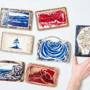
The map duly arrived at the museum in November and is on show along with a larger scale version which covers the floor of an exhibition room so people can ‘walk’ along the streets it depicts.
The map details buildings, trees, even ships at the quayside, it includes several recognisable buildings, including St Peter’s Church, the Almshouses, St Anne’s Chapel, and the castle mound and also one that very little was known about, the Barnstaple Priory.
‘I’d never seen any depiction of those priory buildings, it was the only depiction we had.’ says Todd.
Wendy Clarke, one of the contributors to the book, had already been researching the priory. ‘As the first known original representation of the priory buildings, Newcourt’s plan literally and metaphorically puts the institution back on the map,’ she writes.
The book includes chapters on buildings in Barnstaple at the time of the map, and it provides a detailed look at the town and its people and industries in the 17th century.
‘I’m happy the book is a lasting legacy but it is the map that people will remember,’ says Todd.
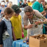
The response to the map from the public, seeing how locals react to it and listening to their comments, is what has moved him the most.
‘The exhibition is filled with everyday people, people who love Barnstaple. I overheard a couple of farmers who’d come in to see it. The joy, the absolute sheer joy in seeing Barnstaple, their town – boom! That was it for me!
‘Out of everything I’ve done over 40 years this has got the most immediate satisfaction. It’s just the sheer pleasure for people.’
He encourages people to visit the museum to see the exhibition. ‘It’s taken five years to bring the map home. I don’t think it will come back to Barnstaple again in my lifetime.’
Richard Newcourt’s map is on view in the Mapping Our Town exhibition at the Museum of Barnstaple and North Devon until February 18.
Barnstaple, 1640-1670: Richard Newcourt's Map, edited by Todd Gray is available through stevensbooks.co.uk and bookshops. £20.
A window on the town
‘The map has been a vehicle to understanding Barnstaple that we never had before and it’s provoked a whole new interest in exploring the town’s history,’ says Todd.
Looking back at the town at the time of Newcourt’s map, says Todd, ‘We tend to think of Barnstaple as being a bit removed, but it was at the height of it.’
Barnstaple was a wealthy and influential town. It was noted for its beautiful plasterwork in various domestic buildings, belonging to Elizabethan and Jacobean merchants. Much of this ancient plasterwork was subsequently destroyed or removed and sold or lost over the years - a fate brought about because the town was prosperous. ‘It had money and so wanted to modernise.’
One ornate ceiling at 62 Boutport Street, now The Bank restaurant, still exists. ‘It’s a treasure of Devon’, says Todd. ‘Every visit to the town I go to see that ceiling.’
The map has allowed Todd and his colleagues to look at the town afresh. One less welcome discovery is that one of the town’s treasures, the beautifully ornate 17th century Dodderidge fireplace (which originally came from 10 Cross Street and is now housed in the current Guildhall), is infact a Victorian reproduction. ‘It is a copy, the original was probably sold in America,’ says Todd – who's now on the trail of trying to find the original.
Devon connections
Richard Newcourt became one of the country’s most highly regarded surveyors. He was one of five men to produce rebuilding schemes for London following the Great Fire in September 1666. His Survey of London, a map published in 1685 was his greatest achievement.
The second son of Philip Newcourt of Tiverton he is most associated with Somerset and his estate at Somerton, but he did have Barnstaple connections, with a family seat at Pickwell Manor near Georgeham.
Travellers’ comments
The book includes several delightful first person descriptions by visitors to the town. One of whom, John Ray who visited in 1662, claimed the streets were so clean ‘as to allow walking in slippers in wintertime’. Infact Barnstaple’s well paved, cobbled and clean streets were a source of admiration until the late 18th and 19th centuries when they appear not to have kept up with modern standards. In 1800 one person remarked that, ‘the little oval pebbles with which its streets are studded, being not only extremely unfavourable to the shoes, but what is much worse, very injurous to the feet.’
A royal descendant?
In 1645 it is believed that a building at 103 High Street, or possibly 62 Boutport Street, was occupied by the Prince of Wales, the future Charles II, as a guest of Grace Beaple, the widow of wealthy merchant, Richard Beaple. The 15-year-old prince was said to have sired a child. ‘This could be the first of his 23 illegitimate children,’ says Todd. The rumour, which has passed down through the generations, cannot be proved for certain but, Todd says, ‘We know enough to sit there and think – this is a possibility’. He adds, ‘Their descendants could still be walking around Barnstaple - and that’ a nice thought!’