Woodlands are wonderful. For so many reasons, trees are vital for the planet – in the process of growing they remove huge amounts of carbon from the atmosphere and their photosynthesis provides the oxygen we breathe. They are also supremely good for biodiversity, hosting myriad wildlife when alive and, when dead, continuing to support many forms of life as they start the long, slow process of subsiding into the rich soil from which they came.
And they are good for the human soul: dappled light, cascading birdsong, the smell of damp earth, the softness of fallen leaves underfoot – all are a treat to our senses. Walking in green spaces has been shown to reduce stress and improve wellbeing.
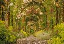
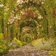
So here we go on a hilly walk for all seasons that visits different kinds of woodland in all their sylvan lushness. In spring, the new beech ‘pennies’ in fresh green hang above our heads; if you’re walking in summer you’ll have dappled shade, in autumn vibrant colour, and in winter the beautiful tracery of naked branches against the sky. Festoons of lichen bear testimony to the clean air. Although within the Dartmoor National Park there is no moorland walking, but Dartmoor reminds you of its presence with frequent chunks of muscular, ancient granite.
Important note: Stage 6, below, is an addendum, and I would recommend that you don’t investigate this marked path. It is only for the ultra-sure-footed and well-balanced – and I only detail it here so that anyone following the map or app who is tempted to explore this marked side-path knows what they are letting themselves in for. It is precipitously downhill, bouncing from tree to tree, and if you stumble you’ll keep going down a vertiginous slope – not even the fittest amongst us can defy gravity and this path drops by 100m over the distance of 120m - scary. It is a public footpath, but it’s a very hazardous one – and once you’re part-way down it, believe me, you won’t want to crawl back up it again. The return to the village is along the road for either option, so you’re not reducing road-walking by risking this stage. Remember, it’s been a good day’s walking when everyone gets back in one piece.

The walk:
1. Start in Bridford’s lovely parish church with its impressive rood screen. Notice the medieval paintings on the panels beyond the screen and the more-recent parish map, created in 1995 and depicting the parish in needlepoint, across a series of nine kneelers.
From the main porch of the church walk down the path and descend the flight of steps. Turn right at the bottom, passing a red post box in a cottage wall, and in just a few metres bear left, downhill, with the road. You swiftly reach the junction with the lane through the village; turn right, passing the entrance to the inn on your right, and walking along a no through road. Notice the three hares on the inn sign, reflecting the roof boss carving in the church.
The lane becomes rough underfoot and soon passes The Old Rectory. In another 150m you pass Rectory Cottage and soon the babbling of Rookery Brook is heard. The track enters a verdant, leafy area and as it swings left to cross the brook don’t go left but keep ahead to a gate that sports a sign about the footpath, conservation area, dogs vehicles etc.

2. Follow the clear path beyond the gate, which soon rises beneath trees and goes through a yellow-arrowed gate. The path continues gently upwards through Hedgemoor Plantation, soft underfoot with years of accumulated leaf litter. Rookery Brook tumbles along down to your right, its mini cascades sparkling over the rocks. Enjoy looking up into some splendid trees.
At a ‘private’ gate a two-way fingerpost directs left, uphill. Follow this fenced path as it climbs and bends about, soon walking alongside the mound of an old boundary on the left, which ends beneath a beech tree that shows signs of once having been pollarded: younger regenerative growth sprouts from the ‘stool’ of the tree’s thick and ancient trunk, which also supports a variety of fungi.

Keep going along the path, though another arrowed gate, and at the next turn right, still on the clear path with a good smattering of ‘keep out’ signs to make sure you don’t stray – there is a whiff of territorialism. The path eventually leads out to a wider track, keep straight ahead until you reach the road.

3. Turn left, and keep straight on at the junction in 70m, towards ‘Reservoirs and Hennock’. In another 400m ignore a forestry track going left into the plantation and continue. The road starts to descend through the aromatic pine woodland of Laployd Plantation, and in another 350m you reach another track on the left, this one with a bridleway sign off the road. Follow this, keeping ahead on the obvious path.

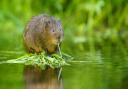
Soon the reflective waters of Kennick Reservoir are glimpsed through the trees on the right. The view along it varies depending on the height of the vegetation. Here we spotted little grebe swimming about – an endearing small bird who always seems to be smiling. Only anglers are allowed on the banks of this lake as the paths are narrow and there is some concern that walkers might get caught in anglers’ back-casts. Hmph.

4. Just over a quarter-mile from the road the path reaches a three-way fingerpost. Turn left here, signed as Laployd Ride, and follow the path uphill, soon entering amongst the elegant loftiness of the conifers. Pause as you climb, to glance back. The reservoir glints beautifully through the tree trunks. Listen to the soughing of the wind in the canopy, the slightest breeze stirs them to voice. After an uphill third-of-a-mile the path arrives at a crossing track by a fingerpost. Turn right, on the South Laployd path, and follow this as it descends and bends about, with further occasional glimpses of the reservoir.
In about 300m, after a sharp left bend, the path passes a mighty granite outcrop: the ‘backside’ of Hollowpark Rock. This tor straddles the parish boundaries of Bridford and Christow but disappeared from the OS map after 1963. Thanks to a campaign by tor-bagger Max Piper, it was reinstated on the maps in 2022.
Continue along the path with farmland to the right. Just over 400m from Hollowpark Rock our path is joined by another bridleway coming down from the left – keep straight ahead for another 200m to the next three-way fingerpost.

5. Here turn left on the bridleway signed to Bridford, soon passing through a granite-posted gateway. Follow the bridleway between hedgerows. In the lushness of summer the ferns can be very abundant along here, but at other times of the year they die down.
The track descends for a third-of-a-mile, then passes through a gateway beside a fingerpost. Turn right here, towards Middle Hole. Please respect their privacy as the path passes near the house, with a substantial glass house over to the left. Follow their drive out to the lane and turn left, soon passing a stone barn conversion and roundhouse.
In 150m you reach a footpath going right. This is the point mentioned in the introduction, where I recommend staying with the lane for the half-mile back to Bridford. The lane is hilly, but safer, and the Bridford Inn awaits – and this easier option shortens the walk by less than a quarter-of-a-mile.

6. Having done it once, I wouldn’t attempt this footpath again – it’s madly precipitous, almost 1:1 by my reckoning, and the stiles aren’t dog-friendly. But for those who don’t wish to heed my serious warning, and so that you know what you’re letting yourself in for, there is a footpath going right off the lane. It runs beside the right-hand boundary until it ducks beneath trees and reaches a stile. Beyond this, the footpath runs along the left-hand field boundary without passing through any gaps on the left, until it reaches another fingerpost. It continues under trees, with an old boundary on the left.
About 300m from the last fingerpost the left-hound boundary bends away, but the path keeps on in the same direction, beginning to descend quite roughly. At this point, I suggest you go back! It gets worse. If you’re doing this, use companions and trees for support and be VERY careful – there’s always the option of sitting down and slithering.
If you’re still capable of reading these directions by the time you hit the footbridge at the bottom, walk (or limp) out to the road. Turn left and follow the hilly lane all the way back to Bridford.

COMPASS POINTS
Start point: Bridford village; nearby postcode: EX6 7HT; grid ref: SX815863
Parking: On-road in Bridford
Map: OS Explorer OL 44 (used to be OL 31) Torquay & Dawlish, 1:25,000 (this scale shows greater detail than the map printed here)
Distance: 5 miles
Terrain: Woodland tracks, paths and very quiet roads. Expect mud
Exertion: Moderate, but strenuously and vertiginously downhill if you include the ‘extra’ section at Point 6 (not recommended)
Dog data: Animals grazing; some stiles on Point 6 have no canine provision but adjacent fences may be negotiable; quiet roads
Refreshments: The Bridford Inn, EX6 7HT (01647 252250). There are also pleasing benches for a picnic in the village gardens, next to the old Methodist Chapel, and in the Woodland Park
Toilets: Compost loo in Bridford’s Woodland Park
Public transport: A bus service calls at the village