
From bluebells and black sheep to beyond-iconic views, enjoy the best of Sussex on these five spring walks that take you over Seaford Head in the east of the county to Chidham Peninsula in the west.

Seaford Head
At the eastern end of the Seaford seafront, where the chalk cliffs begin, is the site of one of the last kittiwake colonies in the south east. Here at Splash Point these gulls return every year in February, building their nests on the narrow ledges of the sheer cliff face. Once the breeding season is over, the gulls leave again in August to spend the rest of the year out in the Atlantic. ‘Kittee-waake, kittee-waake, kittee-waake!’: there’s no mistaking the insistent cry of these onomatopoeically named gulls that fills the air. For the best view, walk right to the very eastern end of the promenade, below the cliffs, before starting the climb up to Seaford Head.
Once on the cliff-top, continue along the coastal path, which initially runs beside the golf course, further on descending to Hope Gap. This is part of the new King Charles III England Coast Path, as well as the Vanguard Way. The former, when complete, will go all the way round the coast of England, a distance of 2,700 miles. The latter, a well-established long-distance path, albeit a much more modest 66 miles, runs from the south London suburbs to the sea at Newhaven. Look out for lambs in the fields beyond the golf course.
From Hope Gap the coast path heads back uphill and along to the Coastguard Cottages and the classic view of the Seven Sisters beyond Cuckmere Haven. There’s plenty of birdlife at Cuckmere Haven, too. Follow the track/access road from the Cottages up to South Hill Barn car park and bear left to continue along the concrete track to the golf course. Turn left along its eastern edge back to the cliff top and retrace steps back to the start.
Note: you can park all along the Seaford seafront. The Martello Tower, which is near the eastern end, houses the Seaford Museum, and is worth a visit when open (11am – 4pm at weekends and bank holidays, as well as 2pm – 4pm on Wednesdays).
Distance: 4½ miles/7km
Start/parking: Martello Tower along seafront, BN25 1JH, grid ref TV485985

Ditchling Common
Located to the east of Burgess Hill, Ditchling Common Country Park, is a popular area of common land, is at its loveliest in the spring when carpeted in bluebells with the blackthorn and hawthorn blossom out, too. There’s a waymarked nature trail round it, which takes in the various habitats and if you’re after even more bluebells., as well as wood anemones, you can see plenty in nearby Blackbrook Wood, which this route takes you through, before heading towards the South Downs.
Beyond the wood you’ll pass the vineyard of the award-winning Artelium Wine Estate. The tasting room and terrace (situated just off the path) are open from Thursday to Sunday for wine by the glass and small plates. At Hayleigh Farm the walk heads west to the charming village of Ditchling (home to the late Dame Vera Lynn) to join the Sussex Border Path back to Ditchling Common.
Distance: 6¼ miles/9.9km
Start/parking Folders Lane East car park, BN6 8SQ, grid ref TQ335181

Pulborough
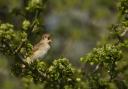
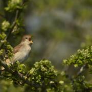
Situated in the beautiful Arun valley, the RSPB Pulborough Brooks Nature Reserve is well worth a visit with a wide variety of birds, including the nightingale, as well as other wildlife, to be seen. There are two trails at the reserve, the two-mile Wetland one, which takes in a number of hides, as well as viewpoints, and the 1½-mile Heathland Trail. The reserve is ideal for families, with a children’s play area, plus activities and events, such as birdsong masterclasses, throughout the year.
The walk starts from Pulborough, a couple of miles to the north, and follows the waymarked WildArt Trail from the station across the Arun Valley to the reserve, with the South Downs forming a stunning backdrop in the distance. Not far from the Visitor Centre you’ll pass the lovely old church at Wiggonholt. Follow the footpaths along the east side of Pulborough Brooks for the return. If coming by car, the section to/from the station can be omitted by starting from the village car park, which shortens the distance by 1½ miles.
Distance: 5¼ miles/8.5km (shorter option 3¾ miles/6km)
Start/parking Pulborough station, RH20 1AH, grid ref TQ043186 or Lower Street car park, Pulborough, RH20 2BQ, grid ref TQ053185. Alternative parking at RSPB Pulborough Brooks.

Bramber
Once an important river port, Bramber lies on the west side of the River Adur a few miles inland from the coast, near Steyning. There is lot of historic interest to see here - the picturesque castle ruins, the Norman church of St Nicholas and a magnificent medieval house, St Mary’s – and some lovely riverside walking, with information panels along the way describing the wildlife and plants to be seen during the different seasons. Birds to look out for in spring include yellowhammer, stonechat, linnet and wheatear.
The castle, which is in the care of English Heritage (free entry), sits on a knoll above the village, with views over the Adur valley. A deep defensive ditch surrounds it and there is a mound (motte) at its centre. The ruins include an imposing stone tower. As well as the adjacent church, this walk also takes in two other ancient churches, St Peter’s at Upper Beeding, the former church to Sele Priory, and St Botolph’s, a Saxon church in the care of the Churches Conservation Trust charity.
Distance: 4¾ miles/7.6km
Start/parking: Bramber village car park, BN44 3WE, grid ref TQ188106. If full, use Bramber Castle car park (entrance drive at A283 roundabout)

Chidham Peninsula
Situated in Chichester Harbour, the Chidham Peninsula faces Thorney Island to the west and Bosham to the east. A circuit of the peninsula makes an ideal short walk. Chichester Harbour is the smallest Area of Outstanding Natural Beauty - or National Landscape, to use the new name - in the south-east and a unique blend of sea and land. Footpaths run along the shoreline of the harbour, which comprises a series of tidal inlets with a narrow mouth to the sea and wonderful views across the water.
This clockwise circuit starts from the car park just south of the village, and heads east to join the coast path, before turning right to follow it down to and round Cobnor Point. Just beyond here, a section along the foreshore floods at high tide and there is no alternative route – so do check tide times beforehand to avoid high tide. Along the foreshore you’ll pass the Cobnor Bird Hide – which is well worth a stop for the views and to learn more about the birds that can be seen.
Just beyond Chidham Point, the walk heads back inland to return to the start with the option of calling in at the local pub, The Old House at Home, on the way.
Distance: 5 miles/8km
Start/parking: Cobnor Farm Amenity Car Park, Chidham Lane, near Chidmere Pond, PO18 8TD, grid ref SU793035